
Garrywhin


Chambered Cairn (Neolithic)
Site Name Garrywhin
Classification Chambered Cairn (Neolithic)
Alternative Name(s) Cairn Of Get
Canmore ID 9046
Site Number ND34SW 4
NGR ND 31327 41124
Datum OSGB36 - NGR
Permalink http://canmore.org.uk/site/9046


- Council Highland
- Parish Wick
- Former Region Highland
- Former District Caithness
- Former County Caithness
ND34SW 4 31327 41124.
(ND 3133 4112) Cairn of Get (NAT)
Chambered Cairn (NR)
OS 1:10,000 map, (1976)
'Cairn of Get': A short horned cairn of Orkney-Cromarty type. Though much dilapidated, this cairn, excavated by Anderson in 1866 (Anderson 1869), is still 8 ft high and is covered with turf and heather. Much of the chamber is visible, the E wall of the inner chamber standing some 5 ft above the debris. The finds, now lost, included ashes, bones (both burnt and unburnt), flint (including leaf-shaped arrowheads) and Western Neolithic pottery.
J Anderson 1869; A S Henshall 1963; R W Feachem 1963.
Cairn of Get, as described and planned above.
Resurveyed at 1:2500.
Visited by OS (N K B) 21 April 1967.
This short horned cairn appears to have originated as a round chambered cairn about 25 ft in diameter.
A S Henshall 1972.
This chambered cairn lies towards the N end of an undulating terrace in heather moorland; it commands extensive views to the N and E, while to the S and W it is overlooked by higher ground. The cairn measures 18m in diameter and 2.25m in height and has pairs of horns projecting on the N and S respectively to form two forecourts. The entrance passage into the chamber, which is 0.5m broad and opens from the S forecourt, is flanked by two portal stones, the tallest on the W standing 0.6m high. The passage is 3.3m long and lined with rubble walls standing up to 0.9m in height in five courses. It appears to be slightly bowed, with both sides curving in to meet the portal stones of the ante-chamber. These stones are much taller that those at the entrance, that on the E being claw-shaped and standing 1.3m high, and that on the W 1m high. The ante-chamber is square on plan, measuring 1.7m from N to S by 1.7m transversely, and is defined by rubble walls up to 1.1m in height in seven courses. On its N side, two large portal stones frame the entrance into the main beehive-shaped burial-chamber, and these stones are taller still; that on the E stands 1.75m high, that on the W 1.5m high. Inside the chamber, the coursed rubble walls incorporate three large slabs on the N, E and W. The chamber measures 3.3m from E to W by 2.8m transversely and its walls still stand up to seventeen courses high. The corbelling for the roof begins to oversail about nine courses above the floor, or a height of 1m.
(YARROWS04 60)
Visited by RCAHMS (ARG, ATW) 16 June 2004
Publication Account (1995)
There is a remarkable series of prehistoric and later monuments 111 the area, including several chambered cairns and an iron-age fort. The path to the Cairn of Get is marked by black and white poles; from the cairn one can walk to other monuments.
The Cairn of Get lies just over the first low ridge. It is a short horned chambered cairn excavated in 1866, when the bones of seven or more people were found in the antechamber, and a deposit of wood ash, burnt and unburnt human and animal bone, flint arrowheads and fragments of pottery in the main chamber. The chamber, which is divided by upright stones, has lost its roof and lies open to view. The two leaning slabs at the back of the chamber were set that way deliberately; above them heavy corbel stones project over the chamber as the start of the roof. The walls facing the sides of the horns can be seen in places.
Some 30m back from the Cairn of Get, in the heather on the inside of a bend in the path approaching it, is a small cairn some 10m in diameter with a cist grave exposed in it. It is uncertain if this is a bronze-age cairn, or nore unusually a Pictish grave of the 1st millennium AD. Beyond the Cairn of Get is a fine stone dam, retaining a now silted loch. This was probably built in the 19th century as part of the works to provide a head of water for Whaligoe Mill (see no. 14). The dam points conveniently to the Fort of Garrywhin (NO 312413) immediately to the north and occupying the top of a broad flat hill some 150m long, with steep sides. A single stone rampart, now much tumbled, runs right round the hill with an entrance at each end. At the north end the rampart was doubled in width and faced with very large upright slabs, of which three survive and give an idea of the original height of the rampart. The interior is now covered with peat and heather, but near the south end are the remains of a stone structure, possibly a later hut circle, while further north is the remains of a small stone cairn, perhaps bronze age.
On the slopes south of the fort, between it and the loch, are a line of three rather dilapidated hut circles, best distinguished by the bracken growing on them. About 150m east from the south end of the fort, and across a fence, is a denuded early bronze-age cairn on a small knoll; it was excavated in 1865, and a burial with beaker pottery found in a central cist. Radiating down the slope from it to the south are 7 or 8 lines of small grey stones, with at least 11 stones in the most complete row. Only 30 stones remain today, but originally there must have been around 80. Some other very ruinous stone rows exist nearby, one gtoUp 220m ESE of the Cairn of Get, and another 200m SSW, the latter also aligned on a cairn, but both hard to see now. On a ridge some 400m east of the Cairn of Get, looking down on Loch Watenan, are the grassgrown remains of a broch within an outer defensive work (NO 317411) and there is another broch further north on the same ridge (ND 318414). Cairn Hanach, or Kenny's Cairn (NO 310408) is built on the edge of higher moorland and shows up on the skyline from Cairn of Get, from which it lies some 450 m southwest. Traces of crofting settlements can be found on the low ground between Cairn Hanach and Groat's Loch.
Information from ‘Exploring Scotland’s Heritage: The Highlands’, (1995).
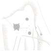
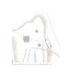
Measured Survey (10 August 2004)
RCAHMS surveyed the chambered cairn at Cairn o'Get (ND34SW 4) on 10 August 2004 with plane table and self-reducing alidade producing a site plan of the cairn and surrounding features, including cists and cairns (ND34SW16) and a limekiln and quarries (ND34SW 397), at a scale of 1:500. The plan was later redrawn in vector graphics software, with illustrations produced at scales of 1:500 and 1:1000.
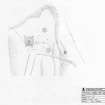
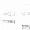
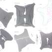
Measured Survey (28 July 2004)
RCAHMS surveyed the Cairn ‘O’ Get chambered cairn on 28 July 2004 with plane table, producing a plan and elevations of the chamber at a scale of 1:50.

