
Forse House


Cairn (Period Unassigned)(Possible)
Site Name Forse House
Classification Cairn (Period Unassigned)(Possible)
Canmore ID 8610
Site Number ND23NW 11
NGR ND 2032 3518
Datum OSGB36 - NGR
Permalink http://canmore.org.uk/site/8610


- Council Highland
- Parish Latheron
- Former Region Highland
- Former District Caithness
- Former County Caithness
ND23NW 11 2032 3518.
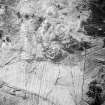
There is a turf-covered robbed cairn, 11.5m in diameter and 0.6m high, at ND 2032 3518, on a false crest at about 400ft OD.
Several stone slabs around the perimeter may indicate a kerb and two upright slabs in the centre set at right angles to each other, 0.2m high, may possibly be the remains of a cist.
Surveyed at 1:2500.
Visited by OS (N K B) 12 May 1967.
(ND 2032 3518) Cairn (NR)
OS 1:10,000 map, (1976)
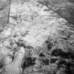
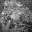
A stony mound generally as described by the previous field investigator. It cannot be classified with certainty as a robbed cairn, as the two slabs, allegedly of a cist, occur some 2.0m from the perimeter, and may be the inner face of a wall, ie. of a hut circle.
Visited by OS (N K B) 22 March 1983.
Scheduled with ND23NW 12, ND23NW 13, ND23NW 37 and ND23SW 6, ND23SW 9, ND23SW 21, ND23SW 22, ND23SW 24, ND23SW 25 as 'Forse House, settlement, field system, burnt mounds and cairns... an extensive area of remains, including those of deserted farmsteads ... together with associated cultivation remains of various dates, small cairns and burnt mounds.'
Information from Historic Scotland, scheduling document dated 30 January 2003.

