
Crosskirk, St Mary's Chapel


Cemetery (Period Unassigned), Chapel (12th Century)
Site Name Crosskirk, St Mary's Chapel
Classification Cemetery (Period Unassigned), Chapel (12th Century)
Alternative Name(s) Chapel Pool
Canmore ID 8005
Site Number ND07SW 1
NGR ND 0249 7008
Datum OSGB36 - NGR
Permalink http://canmore.org.uk/site/8005


First 100 images shown. See the Collections panel (below) for a link to all digital images.
- Council Highland
- Parish Reay
- Former Region Highland
- Former District Caithness
- Former County Caithness
ND07SW 1 0249 7008
(ND 0249 7008) St Mary's Chapel [NR]
(rems of) [NAT]
OS 1:10,000 map, 1975.
See also ND06NW 17.
The remains of a possibly 12th century chapel said in 1726 to be dedicated to St Peter (W Macfarlane 1906) but which writers from Pennant in 1769 (T Pennant 1774) onwards have assigned to St Mary, an assignation supported by the fact that a holy and healing spring well, 15 chains to the S and associated with the chapel, bears that dedication. There is no local traditional dedication.
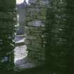
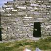
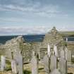
Much the oldest surviving ecclesiastical structure in Caithness, the chapel consists of nave and reconstructed chancel, an anachronistically early feature occurring in the form of sloping door jambs more suited to an Irish-type chapel than to an orthodox medieval structure. Both nave and chancel are roofless, the latter having been rebuilt on the old foundation in 1871 to serve as a burial place for the Gunn family. It measures 11 ft 3 ins E-W by 10 ft 9 ins N-S with walls 2 ft 6 ins thick. Separated from the chancel by a solid wall pierced by a doorway, the nave measures 17 ft 10 ins E-W by 10 ft 11 ins N-S within 4 ft thick drystone walls of irregularly coursed local whinstone. The N wall is 8 ft high, about its original height; the S wall is damaged but still stands 6 to 7 ft high; the W wall is badly damaged, especially externally, and stands to a height of 11 ft 8 ins and the E wall stands 15 ft high. Enough survives of each wall to establish that there has been no window. In the W wall there is an entrance, now closed up, 2 ft 3 ins wide at ground level, 1 ft 9 ins wide at the top, and 3 ft 11 ins high. The entrance to the chancel is of similar height, 2 ft 9 ins wide at ground level and 2 ft 1 in wide at the top. The chapel is surrounded by a graveyard, still in use in 1872, enclosed by stone walls.
T Pennant 1774; Name Book 1872; J Anderson 1873; W Macfarlane 1906; RCAHMS 1911, visited 1910.
Information from H Dryden (MS and plans in the National Museum of Antiquities of Scotland [NMAS] library, SAS Mss Nos. 22 & 190).
Generally as described, the chapel contains seven recumbent grave slabs on which the earliest discernible date is 1692. The graveyard is still in use.
Resurveyed at 1:2500.
Visited by OS (N K B) 28 October 1964.
This was possibly an early religious site since a Pictish symbol stone and evidence of occupation as late as the 8th century were found in the nearby broch (ND07SW 4).
E W MacKie 1975.
St Mary's Chapel, Crosskirk (Information from DoE name plate) is as described by the previous authorities.
Visited by OS (N K B) 13 August 1981.
St Mary's Well is now dry and in a dilapidated condition.
Visited by OS (J B) 28 August 1981.
A grass-covered wall, 31 m long and 0.5 m high, runs NE from the NE corner of the chapel, which is probably superimposed on it.
R J Mercer 1982.
Scheduled with adjacent broch (ND07SW 4).
Information from Historic Scotland, scheduling document dated 30 June 1995.
Antiquarian Observation (August 1871)
Drawings of the chapel of St Mary's, Lybster, Crosskirk, Caithness by Sir Henry Dryden 1871 with notes.
Graveyard Survey (May 1985)
Over the course of 1985, Kirkdale Archaeology carried out a number of graveyard surveys in the northeast of Scotland. The graveyard of St Mary's Chapel was recorded as a part of this project.
Sponsor: Historic Buildings and Monuments
Kirkdale Archaeology
Publication Account (1995)
This simple chapel on the cliff near the sea is one of the oldest ecclesiastical buildings in Caithness and was probably built in the 12th century. It is now roofless, but the rubble-built walls stand almost complete. There is a short nave and a small square ended chancel which may be a later reconstruction on early foundations. The gable ends of the nave show it had a pitched roof, probably thatched. The present entrance in the south wall is modern; the two original doors are in the west and east walls, the latter connecting the nave with the chancel. The sides of the doorways converge towards the top where they are crossed by a flat lintel; such inclined jambs are also found in early Irish churches. There are now no windows, but the new entrance may have destroyed one in the south wall.
The footings of an early chapel of similar plan have been excavated at The Clow, near Watten, (ND 233524), and there is a similar chapel at Skinnet (ND 130620). These small chancelled churches are unlike others in the Highlands at that time, but are familiar in the Northern Isles, and their design was probably derived from Orkney, then ruled by the Norse Earls who also controlled Caithness.
Information from ‘Exploring Scotland’s Heritage: The Highlands’, (1995).

