
Helmsdale, Shore Street, Harbour


Harbour (19th Century)
Site Name Helmsdale, Shore Street, Harbour
Classification Harbour (19th Century)
Alternative Name(s) River Helmsdale; Helmsdale River; Helmsdale Harbour
Canmore ID 7480
Site Number ND01NW 61
NGR ND 03002 15154
NGR Description Centred ND 03002 15154
Datum OSGB36 - NGR
Permalink http://canmore.org.uk/site/7480


- Council Highland
- Parish Kildonan
- Former Region Highland
- Former District Sutherland
- Former County Sutherland
ND01NW 61.00 centred 03002 15154
Harbour [NAT]
OS (GIS) AIB, July 2006.
ND01NW 61.01 ND c. 02863 15182 Pilot Beacon
ND01NW 61.02 ND c. 02964 15122 Foghorn
ND01NW 61.03 ND 03068 15175 Slipway
ND01NW 61.04 ND 03002 15113 to ND c. 02856 15181 West Pier
ND01NW 61.05 ND 03008 15073 to ND c. 03083 15170 East Pier
Location formerly entered as ND 0300 1515.
For (predecessor) Helmsdale, Old Harbour (ND 0272 1529), see ND01NW 62.
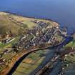
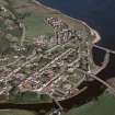
(Location cited as ND 030 151). Helmsdale Harbour, built 1818, engineer John Rennie, extended 1839-41 for the Duke of Sutherland, and rebuilt 1890 for the Helmsdale Harbour Trustees. The older part (ND01NW 62) consists of a quay and pier upstream from the [then] new bridge (ND01NW 58), forming a rectangular basin, and the 1890 part consists of two piers enclosing a roughly triangular basin. On the W side of the Helmsdale River are the ruins of an old breakwater. Designed mainly as a fishing port. Round both harbours are fisher cottages and fish-curing houses (mostly ruined).
J R Hume 1977.
The mouth of the Helmsdale River was one of those listed in a Macfarlane document of the early 17th century as good harbours for ships trading in local produce. Further evidence that it possessed a certain importance before improvement became general is given by the fact of its inclusion on Collins's chart (1776) and earlier on Bishop Leslie's map of the 1570's. The earliest harbour works came only in 1818 with a pier and breastwork which were later enlarged and extended. Shipping from all parts of Britain and Ireland was now (1841) making use of the port. An important fishing station was organised with further construction in 1840, and what Groome describes as a new harbour was built in 1892.
A map of 1833 from Dunrobin Castle marks another pier to the north, between East Helmsdale and Navidale, near a distillery.
The present harbour is outside and immediately to the E of the mouth of the Helmsdale River.
A Graham and J Gordon 1988.
Harbour. Begun in 1818; then consisted of a quay on the N bank of the River Helmsdale indented with a small rectangular basin. In c. 1820 John Rennie proposed the building of breakwaters to shelter the mouth of the river but nothing appears to have been done. The harbour was extended by Alexander in 1823, and in 1841 McDonald and Leslie embanked the river's S shore. Finally, in 1892 James Barron made a roughly triangular basin, built a breakwater (now in ruins) to the S.
J Gifford 1992.

