
Ach An Fhionnfhuraidh


Broch (Iron Age)(Possible)
Site Name Ach An Fhionnfhuraidh
Classification Broch (Iron Age)(Possible)
Alternative Name(s) Suisgill Lodge
Canmore ID 7170
Site Number NC92SW 13
NGR NC 9020 2396
Datum OSGB36 - NGR
Permalink http://canmore.org.uk/site/7170


- Council Highland
- Parish Kildonan
- Former Region Highland
- Former District Sutherland
- Former County Sutherland
NC92SW 13 9020 2396.
(NC 9020 2396) Dun (NR)
OS 6"map, (1963)
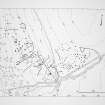
The remains of a dun-like structure discovered during field investigation on a gentle W-facing slope in open moorland. It is oval on plan and measures 13.0m N-S by 8.4m within a flat-topped bank of earth and stone about 5.2m broad and 1.7m high. There is an entrance 1.5m wide in the NW leading to a causeway across an external ditch, 5.0m wide, on the outer lip of which is a rampart, 6.3m broad on the N and 1.5m high above the base of the ditch. On the W, the wall of the 'dun' widens to 11.5m and contains a hollow some 8m by 7m, possibly representing the site of a hut.
Visited by OS (W D J) 2 June 1961
This has been re-assessed as a possible homestead comprising a primary hut circle, with a contiguous possible second hut at a slightly lower level, both on a natural 'platform' formed by an enclosing ditch with an outer bank. The site is overgrown with peat and heather.
The primary hut circle is set into the sloping top of the platform, the interior being 1.3m below its wall on the E side. It measures 10.5m NW-SE by 9.5 m transversely within a wall measuring about 3.0 - 3.5m in the NE, widening to 4.0-4.5m at the entrance in the NW; but this wall becomes very indistinct on the S and W where it levels with the platform.
The second possible hut circle, also set into the slope to a depth of 1.2m, survives as a crescentic hollow about 6.0m in diameter. There are three or four upright stones around the N arc indicating an inner face. The entrance cannot be positively identified, but there is a slight lowering of the wall where it abuts the primary hut, which could indicate that the two were interconnected; alternatively, it could just be a mutilation.
The surrounding dry ditch, some 5.0m broad, is 1.5m maximum depth in the NE, and is shallower and silted on the lower W side. The outer bank is of variable height and thickness (generally about 1.5m above the ditch and 6.0m broad). There is a well-defined causeway across the ditch, and a break in the outer bank, corresponding with the primary hut circle entrance. An early-modern field wall, now ruinous, overlies the outer bank on the S side. Further hut circles and associated cultivation occur to the N and SE (see NC92SW 7, NC92SW 14, NC92SW 35, NC92SW 37 ).
This site has some affinity with two in Strathnaver, viz NC64SE 30 and NC75NW 14.
Visited by OS (N K B) 9 October 1981
Field Visit (5 June 1991)
What may be the wasted remains of a broch and its outworks are situated on gently-sloping ground above the E bank of the River Helmsdale. The broch measures 8.7m in diameter within a wall about 4m in thickness and 1.5m in height. An intermittent band of hollows in the centre of the wall may indicate the presence of intra-mural cells or chambers. On the W a large scoop has been excavated in the core of the wall and an enclosure measuring 6.3m by 4.2m has been built into the scoop and over the ditch. Surrounding the broch, there is a broad, flat-bottomed ditch accompanied by an external bank interrupted on the SSW by a causeway. A secondary, somewhat shallower ditch, with an external bank, has been cut on the W to take account of the enclosure and maintain a complete circuit of bank and ditch. On the SSE a field-bank of relatively recent date crosses the ditch from NNE to SSW.
(KILD91 372)
Visited by RCAHMS (DCC) 5 June 1991.
Publication Account (2007)
NC92 1 ACH an FHIONNFHURAIDH (‘Suisgill Lodge’)
NC/9020 2396
The wasted remains of this possible broch in Kildonan were found during Ordnance Survey field investigations in 1963 [1], standing on a gentle, west-facing slope on open moorland. The building measures about 18.3m in diameter and the wall is about 4m thick and 1.5m in height. A broad-bottomed ditch surrounds the structure, which has also been diagnosed as a homestead [1].
Sources: 1. NMRS site NC 92 SW 13: 2. Swanson (ms) 1985, 795-96 and plan: 3. RCAHMS 1993.
E W MacKie 2007

