
The Ord South


Clearance Cairn(S) (Period Unassigned), Hut Circle (Prehistoric)
Site Name The Ord South
Classification Clearance Cairn(S) (Period Unassigned), Hut Circle (Prehistoric)
Alternative Name(s) The Ord
Canmore ID 5028
Site Number NC50NE 56
NGR NC 5745 0518
Datum OSGB36 - NGR
Permalink http://canmore.org.uk/site/5028


- Council Highland
- Parish Lairg
- Former Region Highland
- Former District Sutherland
- Former County Sutherland
NC50NE 56 5745 0518.
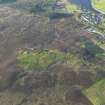
(NC 5745 0518) One hut circle shown as part of settlement.
OS 1:10,000 map, (1970)
On a slight knoll is a hut circle of ordinary form measuring 45ft by 36ft internally. Some 30ft to the N is a 'rectangular construction' measuring internally 6ft 8ins NE-SW by 3ft 10ins transversely, formed of sharp flat-edged boulders set on end around three sides, the end towards a cup-shaped hollow adjacent to the NE being open. There is no appearance of a well, and a considerable number of small stones lie about the interior to a height of 8ins. There are several mounds in the vicinity.
Visited by OS (W D J) 4 July 1963.
RCAHMS 1911.
On a low isolated rise surrounded by marshy ground is a solitary stone-walled hut within a minor field system. It is oval measuring internally 13.5m NW-SE by 10.5m transversely within a wall spread to 2.0m all round. (This is unusually narrow for the size of hut). A portal stone flanks the W side of the simple entrance in the SE arc. The "rectangular construction" is as described by RCAHMS. Its purpose is unknown; the "cup-shaped hollow" adjacent may be a quarry for its construction.
The minor field system comprises a number of stone clearance heaps to the north and south-east of the hut (the 'mounds' noted by RCAHMS) but no cultivation plots are discernible.
Re-surveyed at 1:10,000.
Visited by OS (N K B) 27 July 1976.
Scheduled with NC50NE 13-14, 16, 17, 19, 22, 38-9, 46, 54-5 and 81-2 as The Ord, chambered cairns, cairns, settlements and field systems.
Information from Historic Scotland, scheduling document dated 14 February 2002.
Ground Survey (22 February 2010 - 18 March 2010)
NC 575 050 A topographic survey of the scheduled area and a 100m buffer zone around the The Ord was carried out 22 February–18 March 2010. The area contains a high density of archaeological monuments, including Neolithic funerary monuments and remains of Bronze Age settlements and agriculture. Although the distribution of the major features was known, this survey added detail and increased the accuracy of information obtained in previous surveys. The survey also identified several previously unrecorded features. In total over 450 individual archaeological features were recorded including a burnt mound, c35 hut circles, 14 rectangular buildings and over 300 clearance cairns.
Archive: RCAHMS
Funder: The Forestry Commission Scotland

