
Ferry House


Milestone (19th Century)
Site Name Ferry House
Classification Milestone (19th Century)
Canmore ID 297968
Site Number NC36NE 106
NGR NC 3702 6603
Datum OSGB36 - NGR
Permalink http://canmore.org.uk/site/297968


- Council Highland
- Parish Durness
- Former Region Highland
- Former District Sutherland
- Former County Sutherland
Field Visit (2008)
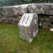
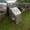
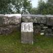
This milestone, which is situated immediately above the slipway (NC 3708 6603) at Ferry House, stands on the eastern verge of the public road (NC36NE 101) that links the slipway to the lighthouse (NC27SE 3.00) at Cape Wrath.
The granite block measures 0.3m square in section by 0.48m in maximum height. The top of the front face comprises a large square facet, which has been painted white, on which there is an incised number eleven (painted black), denoting the distance in miles to the lighthouse. The top of the stone comprises a flat surface some 0.12m in width and the rear of the stone, which is set close to the face of a low stone wall, is vertical.
The exact date of erection of the milestone is unknown, but it was probably soon after the road was adopted as a public highway in 1833 and it was certainly in place by 1874, when it was surveyed for the 1st edition of the OS 6-inch map (Sutherland 1878, sheet V). A local tradition that the milestones along the 11 mile length of the road were fabricated by lighthouse keepers cannot be substantiated, but it would provide an explanation why there is a variation in their respective designs and dimensions.
Visited by RCAHMS (JRS) 11 August 2008.
Field Visit (2008)
NC36NE 106 3702 6603
This milestone, which is situated immediately above the slipway (NC 3708 6603) at Ferry House, stands on the eastern verge of the public road (NC36NE 101) that links the slipway to the lighthouse (NC27SE 3.00) at Cape Wrath.
The granite block measures 0.3m square in section by 0.48m in maximum height. The top of the front face comprises a large square facet, which has been painted white, on which there is an incised number eleven (painted black), denoting the distance in miles to the lighthouse. The top of the stone comprises a flat surface some 0.12m in width and the rear of the stone, which is set close to the face of a low stone wall, is vertical.
The exact date of erection of the milestone is unknown, but it was probably soon after the road was adopted as a public highway in 1833 and it was certainly in place by 1874, when it was surveyed for the 1st edition of the OS 6-inch map (Sutherland 1878, sheet V). A local tradition that the milestones along the 11 mile length of the road were fabricated by lighthouse keepers cannot be substantiated, but it would provide an explanation why there is a variation in their respective designs and dimensions.
Visited by RCAHMS (JRS) 11 August 2008.

