
Dun Canna


Fort (Prehistoric)
Site Name Dun Canna
Classification Fort (Prehistoric)
Canmore ID 4530
Site Number NC10SW 1
NGR NC 1116 0080
Datum OSGB36 - NGR
Permalink http://canmore.org.uk/site/4530


- Council Highland
- Parish Lochbroom
- Former Region Highland
- Former District Ross And Cromarty
- Former County Ross And Cromarty
NC10SW 1 1116 0080
(NC 116 0080) Dun Canna (NAT)
Fort (NR)
OS 1:10,000 map, (1971)
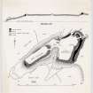
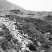
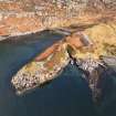
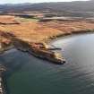
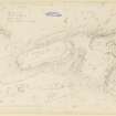
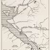
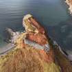
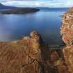
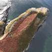
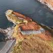
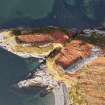
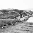
The fort of Dun Canna is situated on a promontory, the cliffs along the sides rising to 40' above high water mark. The promontory is connected to the mainland, on which there is an annexe, by a neck of land 37' wide.
The fort is roughly rectangular and measures 140' x 30' within a single massive dry-stone wall of which the debris varies from 10 to 18' thick. The NW side has almost completely disappeared and the entrance was presumably at a gap 6'6" wide in the NE end. There are no signs of any structures in the interior.
The annexe, of irregular shape, measures c. 140' x 95', within a single massive dry-stone wall that in part at least was 12' - 14' thick. In this area the debris of the wall is 40' thick and rises to a height of 12' above the interior. A narrow gap in the NE corner, opposite the foundations of a late cottage, is obviously intrusive, and the original entrance is situated in a re-entrant angle of the wall in the N side at the head of an easy approach. In the exposed wall face, on the S side of the entrance, there is a rebate resembling the check of a door. There may have been a wall between the annexe and the neck of land, with a narrow gap for entrance, but the N side of the neck was defended by a wall while the S side may have been similarly defended. The interior of the annexe is featureless.
C Calder and K Steer 1951.
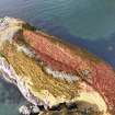
'Dun Canna' - A fort generally as described and planned by Calder and Steer (C Calder and K Steer 1951). The westerly enclosure measures 43.0m by 13.0m within a partly overgrown wall reduced by quarrying and slip on the NW to a thin scatter of debris. Elsewhere, although no facing stones are visible, the spread of rubble would suggest a wall thickness of between 3.0m and 5.0m. The entrance planned by Calder and Steer (C Calder and K Steer 1951) is suspect. Here the tumbled wall is overgrown by a band of turf and there is no hollow through it as one might expect. The entrance, however, is not evident elsewhere.
The annexe wall also has almost been destroyed by slip and quarrying on the NW. Elsewhere the massive band of rubble (up to 10.0m wide) suggests a wall of greater proportions than that of the westerly enclosure, but, although it may have been higher, it seems to have been of the same thickness. The outer and inner faces are frequently visible in the rubble (the inner face to a height of 1.2m) giving a wall thickness in the NE of 2.8m, increasing to 4.3m half-way along the E side and then decreasing again to 3.5m at the SE corner. This increase in thickness is due to the wall crossing a hollow where its extra height would demand a more solid base. There is no trace of the rebate in the S side of the entrance seen by Calder and Steer (C Calder and K Steer 1951).
The better state of preservation of the annexe wall compared to the wall of the W enclosure suggests it may be later.
Revised at 1:10,000.
Visited by OS (J M), 10 July 1974.
C Calder and K Steer 1951.
Measured Survey (October 1947)
Following the report of an unrecorded vitrified fort at Dun Lagaidh, Ullapool, in October 1947 Kenneth Steer and Charles Calder, RCAHMS, surveyed the site, together with a number of monuments in the vicinity.
Source: C S T Calder and K A Steer 1951
Publication Account (1995)
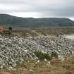
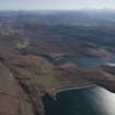
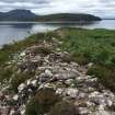
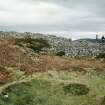
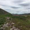
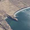
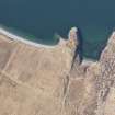
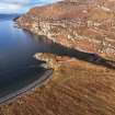
This stone-walled fort is built on a promontory projecting into the sea at the north end of a long sandy beach, and the walls for the most part follow the high rocky cliffs of the promontory. There are two enclosures, both defended by thick stone walls now badly collapsed. The inner enclosure at the end of the promontory is long and narrow, and the outer enclosure is larger and has a thicker wall. Parts of the original wall-faces may be distinguished amid the mass of tumble.
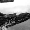
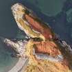
The modern path across the outer wall passes the ruin of a recent stone house built into the fallen wall. This is not the line of the original entrance,which was on the steep northeast side of the promontory where the ends of the wall overlapped to form a short entrance passage, now overgrown with heather. This would have been provided with wooden gates. The approach to the entrance was thus along the side of the hill, where it would have been more difficult to rush the gate. The position of the entrance to the inner enclosure is unknown.
Back near Blughasary, on the south side of the River Runie and some 100m west of the bridge is a small mill of the 18th or 19th century AD, with the two millsrones still lying in the ruins.
Information from ‘Exploring Scotland’s Heritage: The Highlands’, (1995).
Note (3 February 2015 - 18 May 2016)
Dun Canna is situated on a precipitous and rocky coastal promontory at the N end of the beach in Camas Mor. Its defences comprises two elements: an inner enclosure on the crest of the seaward end, from which the ground slopes down to a sheer cliff everywhere except the NE, where gullies cutting in to either side have created a relatively narrow neck; and an outer enclosure taking in a larger and less precipitous area of the promontory on the landward side of the neck. The inner enclosure is roughly sub-rectangular on plan and measures about 43m from NE to SW by a maximum 13m transversely (0.05ha) within a wall reduced to a band of rubble spread between 3m and 5.5m in thickness; a run of outer face is visible at the SW end. A gap in the wall at the NE end was proposed by Charles Calder and Kenneth Steer as the position of the entrance (1949), but in 1974 John Macrae of the OS could not detect any hollow through the band of rubble here. The wall of the outer enclosure has been more massive, in places spread no less than 12m thick, though the wall itself ranges between 2.8m and 4.3m in thickness; the lines of both faces can be identified, the inner standing up to 1.2m high. A gap beside the ruin of a cottage set into the rubble on the NE is the result of later disturbance, probably to give access to the plots of lazy-beds that have been cultivated across the interior, but there is an original entrance in a re-entrant above the cliff-edge forming the NW margin of the promontory. Here the terminals of the walls overlap in such a way as to expose the left-hand side of the visitor approaching from the exterior; Calder and Steer found a check three courses high exposed in its S side. The outer wall encloses an additional 0.13ha, returning along the cliff-edge on the NW towards the inner enclosure, but petering out on the SE on the landward side of the gully forming the neck. While the configuration of the defences was construed as a citadel and annexe by Calder and Steer, there is no reason that the outer was not a fort of about 0.22ha in its own right.
Information from An Atlas of Hillforts of Great Britain and Ireland – 18 May 2016. Atlas of Hillforts SC2778

