
Lewis, Stornoway, Seaplane Base


Seaplane Base (20th Century)
Site Name Lewis, Stornoway, Seaplane Base
Classification Seaplane Base (20th Century)
Canmore ID 106121
Site Number NB43SW 30
NGR NB 4192 3281
Datum OSGB36 - NGR
Permalink http://canmore.org.uk/site/106121


- Council Western Isles
- Parish Stornoway
- Former Region Western Isles Islands Area
- Former District Western Isles
- Former County Ross And Cromarty
NB43SW 30 4192 3281
See also NB43SW 55.01
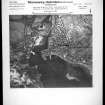
A slipway for seaplanes is visible on a Luftwaffe aerial photograph taken in 1940. Two flying-boats are visible in the water.
Information from RCAHMS (KM) 14 August 1996.
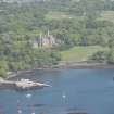
The harbour and Lews Castle were utilised by the Fleet Air Arm during WW II. Lews Castle was used for accommodation and Walrus Flying boats used the harbour. In addition, the harbour was used by convoy escort frigates and corvettes as a working up base. The area also housed the RAF air-sea rescue units who operated from Stornoway Harbour and used the Castle (NB43SW 55.01) for accommodation. No identifiable remains could be found on the date of visit.
J Guy 2002; NMRS MS 810/12, 50

