
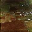
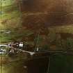
Lewis, Ballantrushal


Township (Period Unassigned)
Site Name Lewis, Ballantrushal
Classification Township (Period Unassigned)
Canmore ID 131361
Site Number NB35SE 43.05
NGR NB 3820 5360
NGR Description Centred NB 3820 5360
Datum OSGB36 - NGR
Permalink http://canmore.org.uk/site/131361


- Council Western Isles
- Parish Barvas
- Former Region Western Isles Islands Area
- Former District Western Isles
- Former County Ross And Cromarty
Note
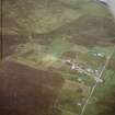
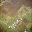
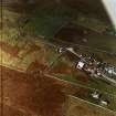
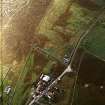
A crofting township, comprising seventeen roofed and two unroofed buildings is depicted on the 1st edition of the OS 6-inch map (Isle of Lewis Ross-shire 1853, sheet 5). Twenty-one roofed and six unroofed buildings, some enclosures and a field-system which overlays a former township (See NB35SE 43.01) are shown on the current edition of the OS 1:10000 map (1974).
Information from RCAHMS (AKK) 10 January 1997.

