
Lewis, Tolsta Chaolais


Township (Period Unassigned)
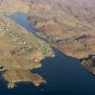
Site Name Lewis, Tolsta Chaolais
Classification Township (Period Unassigned)
Canmore ID 137134
Site Number NB13NE 32.02
NGR NB 1940 3770
NGR Description Centred NB 1940 3770
Datum OSGB36 - NGR
Permalink http://canmore.org.uk/site/137134

- Council Western Isles
- Parish Uig
- Former Region Western Isles Islands Area
- Former District Western Isles
- Former County Ross And Cromarty
NB13NE 32.02 centred on NB 1940 3770
A township, comprising four unroofed buildings and two enclosures is depicted on the 1st edition of the OS 6-inch map (Island of Lewis, Ross-shire 1854, sheet 18). It is not shown on the current edition of the OS 1:10000 map (1974).
Information from RCAHMS (AKK) 24 September 1997.

