
St Kilda, Hirta, Gleann Mor, Structure E


Cellular Building, Gathering Fold (Post Medieval), Shieling Hut (Medieval)(Possible)
Site Name St Kilda, Hirta, Gleann Mor, Structure E
Classification Cellular Building, Gathering Fold (Post Medieval), Shieling Hut (Medieval)(Possible)
Canmore ID 294883
Site Number NA00SE 16
NGR NA 08779 00020
Datum OSGB36 - NGR
Permalink http://canmore.org.uk/site/294883


- Council Western Isles
- Parish Harris
- Former Region Western Isles Islands Area
- Former District Western Isles
- Former County Inverness-shire
Field Visit (3 September 2009)
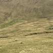
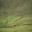
This gathering fold stands at the foot of the long, grass and boulder strewn slope that descends from Mullach Mor. Immediately to the N, there are the heavily robbed remains of a possible cellular structure.
Visited by RCAHMS (ARG, SPH) 3 September 2009
Measured Survey (5 September 2009 - 9 September 2009)
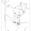
RCAHMS surveyed Gleann Mor, Hirta, St Kilda between 5-9 September 2008, using GPS data and ground observation, to produce a site plan at a scale of 1:500 across five survey sheets. These survey drawings were later used as the basis for a site plan redrawn in vector graphics software for publication at a scale of 1:2500 (Gannon and Geddes 2015,84)
Condition Survey (December 2012)
A monitoring survey of twenty structures in Gleann Mor was undertaken in 2012.
NTS 2012

