
North Ronaldsay, Senness


Settlement (Period Unknown)
Site Name North Ronaldsay, Senness
Classification Settlement (Period Unknown)
Canmore ID 3632
Site Number HY75NE 12
NGR HY 7751 5553
NGR Description Centred at HY 7751 5553
Datum OSGB36 - NGR
Permalink http://canmore.org.uk/site/3632


- Council Orkney Islands
- Parish Cross And Burness
- Former Region Orkney Islands Area
- Former District Orkney
- Former County Orkney
Field Visit (July 1979)
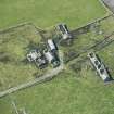
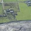
Deserted buildings on W side of track are on a very
noticeable irregular rise 1.5m high, could be just a dune.
NoSAS index NRO 23, J Hedges Sept 77.
Farmstead on a typical tell mound.
Information from Orkney SMR (RGL) Jul 79.
Note (1980)
Sennes, North Ronaldsay HY 7750 5550 HY75NE
Derelict buildings occupy summit of a tell 1.5m high.
RCAHMS 1989
(OR 210)
Field Visit (1999)
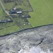
The abandoned farmstead at Eastings is built over a substantial artificial mound which stands up to 1.5m high. It is located some 50m from the coast edge. On the coast, shell midden, comprising solely of limpet, is exposed in the eroding section. The section extends for 4m and is up to 0.5m deep. Ref.: RCAHMS (1980), #111).
Moore & Wilson 1999.
Coastal Zone Assessment Survey, 1999

