
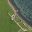
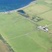
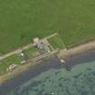
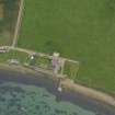
Carrick House, Pier


Pier (Period Unassigned)
Site Name Carrick House, Pier
Classification Pier (Period Unassigned)
Alternative Name(s) Bay Of Carrick
Canmore ID 298157
Site Number HY53NE 4.02
NGR HY 56679 38530
Datum OSGB36 - NGR
Permalink http://canmore.org.uk/site/298157


- Council Orkney Islands
- Parish Eday
- Former Region Orkney Islands Area
- Former District Orkney
- Former County Orkney
HY53NE 4.02 56679 38530
The stone built pier is situated about 35m N of Carrick House (HY53NE 4.00).
It is depicted on the 1st Edition of the OS 25-inch map (Orkney and Shetland, 1881, sheet lxxx) with a flagstaff at the SW (shore) end.
Information from RCAHMS (DE), March 2009

