
Eday, Fold Of Setter


Enclosure (Period Unassigned)
Site Name Eday, Fold Of Setter
Classification Enclosure (Period Unassigned)
Alternative Name(s) Stone Of Setter; Carrick
Canmore ID 3147
Site Number HY53NE 14
NGR HY 5642 3750
Datum OSGB36 - NGR
Permalink http://canmore.org.uk/site/3147


- Council Orkney Islands
- Parish Eday
- Former Region Orkney Islands Area
- Former District Orkney
- Former County Orkney
HY53NE 14 5642 3750.
(HY 5642 3750) Fold of Setter (NR).
OS 6" map, Orkney, 2nd ed.,(1900).
A large circular enclosure of unknown date or purpose, situated on low-lying ground, and measuring 94 yds. in diameter within a peat and heather covered wall which is 7' thick at base. (Information from Mr R J Hebden, Eday). Broken fragments of masonry show through the covering. The interior is rough and heather-covered.
The name comes from the supposition that it was an ancient Picts cattle-fold. (Name Book 1879).
J Farrer 1859; Name Book 1879; G Petrie 1927; RCAHMS 1946.
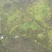
A roughly circular enclosure, still known as Fold of Setter, occupying a NE-facing slope. Its W arc is partially destroyed, and the N arc partially lost in boggy ground. There is no definite entrance visible. Near the centre is a heather-covered mound of stones, c.2.0m in diameter and 0.2m high. Unable to classify.
Re-surveyed at 1/2500.
Visited by OS (AA) 3 August 1970.
300m N of the Stone of Setter (HY53NE 6), the enclosure-wall of the Fold of Setter is traceable with some difficulty in rank grass and heather. The roughly circular area is some 85m across and the wall-footing was about 2m wide; no en trance can be identified, but there are considerable segments of the circuit where the wall cannot be seen.
RCAHMS 1984, visited September 1983.
Field Visit (8 May 2013)
This enclosure is situated on a gentle NE-facing slope immediately ENE of the Old School. It measures about 83m in diameter within a spread grass-, heather- and moss-grown bank 4.5m in thickness and to 0.5m in height. Its perimeter is well-defined except on the NNW to E arc where the rough pasture gives way to waterlogged, peaty ground beyond a post-and-wire fence that crosses the site. The boundary of a rhomboidal enclosure immediately NNW of and associated with the school partly overlies its W arc. There is no clear trace of an entrance and the mound at its centre appears to be natural. An open drain crosses the site from SE to NW. There are extensive traces of lazy bedding to the S and W of the enclosure and there are faint indications that this may extend into its interior.
Visited by RCAHMS (ATW) 8 May 2013.

