
Hatston Airfield


Aircraft Hangar(S) (20th Century)
Site Name Hatston Airfield
Classification Aircraft Hangar(S) (20th Century)
Canmore ID 269623
Site Number HY41SW 135.04
NGR HY 43473 12911
NGR Description HY 43576 12966, HY 43473 12911 and HY 43316 12992
Datum OSGB36 - NGR
Permalink http://canmore.org.uk/site/269623


- Council Orkney Islands
- Parish Kirkwall And St Ola
- Former Region Orkney Islands Area
- Former District Orkney
- Former County Orkney
HY41SW 135.04 43576 12966, 43473 12911 and 43316 12992
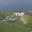
Three concrete bases for aircraft hangar bays with low earth bomb blast banks are situated at the NW end of the airfield. The blast protection on the SE side of the centrally located of the three remaining bays is not an earth bank, but a concrete wall, which would appear to be an original construction as it is visible on RAF vertical air photographs (CPE/Scot/UK 188, 4176-4177, flown 10 October 1946).
The three bays once formed part of a group of of five Mainhill or 'S' type hangars all visible within earth banked protection on the 1946 images (ibid). However, this group was not part of the original construction phase as they do not appear on the WW II images (NLA 16, 617-618, flown 22 June 1941), which shows that this area was a grass dispersal area with a possible light anti-aircraft emplacement.
Visited by RCAHMS (DE, SW), August 2000
Watching Brief (25 August 2014 - 17 February 2015)
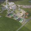
A watching brief and topographic survey was undertaken by Orkney Research Centre for Archaeology (ORCA) on the site of Hatston Enterprise Area, Kirkwall, Orkney.
Following consultation with the Local Authority Planning Archaeologist, ground-breaking works associated with the creation of roads and the installation of services were monitored between 25/08/2014 and 17/02/15.
The results of the watching brief show that some remains associated with the WWII airfield at Hatston are present on site. A tarmac track-way which lead to five aircraft hangars and appears on contemporary WWII aerial photographs was observed partially beneath the topsoil. The blast bank of one of these aircraft hangars was partially removed revealing its composition and exposing the structure of the base of the hangar. This feature was recorded by topographic survey prior to its removal.
Other features of anthropogenic origin observed during the watching brief were numerous post-medieval and modern field drains together with modern disturbance associated with levelling or drainage and the construction of the adjacent road.
Infromation from Orkney Research Centre for Archaeology (ORCA).
Watching Brief (8 January 2018 - 15 January 2018)
A watching brief undertaken by Orkney Research Centre for Archaeology in advance of the development of a lay-down area off Galt's View, Hatston, Kirkwall. Following consultation with the Local Authority Archaeologist all ground breaking works associated with the project were monitored. This consisted of the removal of the remains of an aircraft hangar which was part of the airfield at Hatston, part of the
wartime defences of Scapa Flow The watching brief recorded further information regarding the construction of the aircraft hangar but no further features or material of archaeological significance were identified. Since the entire development has been monitored, no further work was recommended.
Information from Orkney Research Centre for Archaeology (ORCA).

