
Netlater, Manse Of Harray


Broch (Iron Age)
Site Name Netlater, Manse Of Harray
Classification Broch (Iron Age)
Alternative Name(s) Nettletar; Burn Of Nettleton; Harray Manse
Canmore ID 2030
Site Number HY31NW 38
NGR HY 3232 1741
Datum OSGB36 - NGR
Permalink http://canmore.org.uk/site/2030


- Council Orkney Islands
- Parish Birsay And Harray
- Former Region Orkney Islands Area
- Former District Orkney
- Former County Orkney
HY31NW 38 3232 1741.
(HY 3232 1741) Brough (NR)
OS 6" map, Orkney, 2nd ed., (1903).
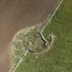
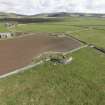
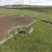
The remains of a broch, situated on low ground about 200yds S. of Harray Manse, which were investigated by the minister, the Rev. Dr Trail, many years before 1929. (G Petrie). It measured from 33ft to 33ft 6 ins internal diameter, with walls 12ft thick and 6ft 6 ins high, at the west arc. The entrance, now obliterated, was in the east, and there were three mural cells, of which only one remains, in the west. Within the broch is a rock-cut well, choked with debris, and fragments of walling, probably of a later occupation.
A rough stone wall, 3ft thick, surrounded the broch at a distance of 3ft: another wall and a number of small cells occurred outside the broch on the east side. Finds include a human skull within the broch and two large rude fire-baked clay urns with triangular stone covers found outside the south wall of the broch.
RCAHMS 1946.
The remains of a broch, generally as described by the Commission. Only the west arc of the broch-walling, containing part of a mural cell at its south end, and the choked well remain: all trace of the walling in the centre, the wall surrounding the broch, and the outworks on the east side, have disappeared. The present whereabouts of the finds cannot be ascertained.
Resurveyed at 1/2500.
Visited by OS (NKB) 15 June 1966.
Scheduled as Nettletar, broch.
Information from Historic Scotland, scheduling document dated 2 December 1999.
Antiquarian Observation (1860 - 1870)
Loose drawings of sites in Orkney and Shetland in the Society of Antiquaries Collection (SAS 487), mainly by George Petrie.
Antiquarian Observation (1862 - 1870)
Drawings by George Petrie of sites in Orkney and Shetland in sketchbook MS 28/487/7 in the Society of Antiquaries of Scotland Collection.
Publication Account (2002)
HY31 14 NETLATER ('Manse of Harray') HY/32321741
This probable solid-based broch in Harray stands on flat ground and was dug into by the Rev. Wm. Traill of Harray in about 1860; the results were described by Petrie [3] (visited 19/7/1963). The features Petrie describes were not all seen by him [6, 72].
The building is now badly ruined and, though the circuit was complete when Petrie planned it, only half now remains; it has been utilised as part of a field wall. On first exposure the circular wall was found to be 3.7 m (12 ft.) thick and the entrance -- now destroyed -- was on the E. The latter was 0.84 m (2.75 ft.) wide at the exterior and retained this width for the first 1.8 m (6 ft.), as far as the door-frame; these were formed of slabs on set on edge and projecting from the walls at right angles. Thereafter the passage was 1.2 m (4 ft.) wide. There were no guard cells. The doorway to the mural stair was at 8.30 o'clock with a large cell leading off to its left and there were then 19 steps rising inside the wall on the right. A little of the stair-foot guard cell can still be seen at the SE end of the surviving wall. There were two more oval mural cells, one at 11 o'clock and the other at 3 o'clock. When the Commission visited the site in 1929 the wall was 1.98 m (6.5 ft.) high on the W.
In the interior there were various slabs of stone set on edge into the floor including two in line with the sides of the entrance passage which in effect projected these into the central court; presumably these features are secondary. One of the slabs had a hole in it, perhaps for tethering an animal [3. fig. 7]. A deep well had been cut into the rock inside the broch and had steps leading down into it [3, figs. 8 and 9]; it was 2.7 m (9 ft.) deep and had water in it when found.
Traces of outbuildings were found around the broch and there was a second well outside the entrance (probably inside Chamber I on Petrie’s plan); this was supposed to have been connected to a nearby burn by a drain. Around the broch was a surrounding wall about 90 cm (3 ft.) thick and the same distance from it; Petrie was informed that it was "only faced on the side next to the broch". One might hazard a guess that this concentric and ill-made "wall" was the debris of the upper walls of the broch which had been piled around the base in a manner encountered elsewhere. Other features had been destroyed before Petrie could see them.
Dimensions. External diameter 17.4 m (57 ft.), internal diameter 10.1 - 10.2 m (33 - 33.5 ft.): walls proportion 42.1%. Petrie gave the interior diameter as 10.1 m (33 ft.) and the wall thickness as 3.6 m (12 ft.).
Finds. None are mentioned in Petrie's published account except for two large pottery urns found set in the ground outside the broch and with carefully cut triangular stone covers. They contained calcined bones. Laing illustrates a decorated bronze penannular fibula of Medieval date which was then in the possession of Dr. Traill who said he had found it in the Netlater broch ([2], 70, fig. 4).
More finds are recorded in Petrie's notebook and have been listed [6, 75]. They include a bone long-handled comb, a decorated bone socketed handle, and objects of whalebone. Metal objects included a second Medieval penannular brooch and a probable bronze bracelet. Stone items included a possible perforated loom-weight, “vessels”, a handled lamp and “querns”.
Sources: 1. OS card HY 31 NW 38: 2. Laing 1868: 3. Petrie 1890, 78-81: 4. Fraser 1923, 31-8: 5. RCAHMS 1946, 2, no. 13, 13-15 and fig. 77; 6. Hedges et al. 1987, 73-5 and pls. 3.4 and 3.5 (ms plan and elevations by Dryden).
E W MacKie 2002

