
Twatt Airfield, Control Tower


Control Tower (20th Century)
Site Name Twatt Airfield, Control Tower
Classification Control Tower (20th Century)
Canmore ID 104535
Site Number HY22SE 58.03
NGR HY 26223 22942
Datum OSGB36 - NGR
Permalink http://canmore.org.uk/site/104535


- Council Orkney Islands
- Parish Birsay And Harray
- Former Region Orkney Islands Area
- Former District Orkney
- Former County Orkney
HY22SE 58.03 26223 22942
Control tower with operations/communications block underneath.
Visited by RCAHMS (DE) May 1996.
The control tower built 1941-42, is unusual in that it is also built on top of the operations block. The whole structure was made ready for demolition and holes were drilled in the structure for explosives. In the event demolition was averted at the last minute, though the drilled holes can still be seen in the walls of the building.
Visited by RCAHMS (DE
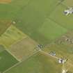
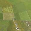
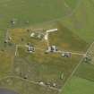
Combined Royal Naval Air Service (RNAS) control tower and operations block, set in open landscape now comprising principal building of Twatt Airfield (former HMS Tern). Rendered brick. 3-storey, rectangular-plan control room and watch office adjoining single-storey operations block to form T-plan.
Part of a B Group at Twatt Airfield including: Combined Control Tower and Operations Block; 5 Air-Raid Shelters; 2 Pillboxes (see separate listings). The Royal Naval Air Service combined control tower and operations building at Twatt Airfield is an important survival of a Second World War airfield building in Orkney.
The building is an early example of this integrated design, similar to early watch offices with attached operations rooms found on RAF satellite bomber airfields in the English midlands. The blast walls and earthwork embankments surrounding the operations block to roof level indicate the perceived level of threat and the importance of maintaining airfield operations in Orkney. The internal plan also differs from standardised RNAS control tower design with a suite of rooms surrounding a central operation room at the core providing additional protection from potential bomb and gas attack. There is an internal hatch rising through the floors to the watch room. Most of the outer rooms have a window for light and ventilation. The structure occupies a prominent position on open ground within the surrounding low-lying landscape.
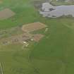
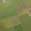
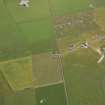
The strategic contribution of Orkney during World War II was nationally significant. Air defences in Orkney were a significant contributor to national security with strikes from airfields in Orkney helping to counter U-boat, surface vessel and air threats over the North Sea and at Scapa Flow. The airfield at Twatt was begun in 1940 and commissioned as HMS Tern in 1941 as a satellite of Hatston airfield for the Royal Marine engineers and remained in service until 1949. The hub of the Royal Navy's sea base operations were located at Lyness at the entrance to Scapa Flow including the Wee Fea Naval Communications and Operational Centre (see separate listings). Royal Naval Air Stations were separate from the Air Ministry and therefore developed their own distinct airfield architecture and layout. Most satellite airfields had smaller watch offices although throughout the war many were adapted as needs changed. The RNAS airfield layout tended to have 4 intersecting runways rather than the 'A' plan layout favoured by the Air Ministry (RAF). The interest of the control tower is increased by the survival of various associated WWII structures.
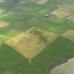
Of the four main military airfields in Orkney, Twatt has the greatest level of surviving WWII infrastructure with little remaining at Hatston, Skeabrae and Grimstter (Kirkwall). The surviving elements include 5 concrete air-raid shelters and 2 octagonal concrete pill boxes (see separate listings). None of the aircraft hangers remain. Other remains include the brick shells of the vehicle and parachute stores, sick bay/decontamination unit and generator house and the projection room section of the former cinema. The airfield covered 440 acres of land in 1941, extended to a total of 564 acres in 1943. There are three abandoned 19th century farmsteads within the perimeter. (Historic Scotland)

