
Sullom Voe, Seaplane Base


Seaplane Base (20th Century)
Site Name Sullom Voe, Seaplane Base
Classification Seaplane Base (20th Century)
Alternative Name(s) Garths Voe; Voe Of Scatsta
Canmore ID 277819
Site Number HU47SW 45
NGR HU 4015 7339
NGR Description Centred HU 4015 7339
Datum OSGB36 - NGR
Permalink http://canmore.org.uk/site/277819


- Council Shetland Islands
- Parish Delting
- Former Region Shetland Islands Area
- Former District Shetland
- Former County Shetland
HU47SW 45 centred 4015 7339
Incoporates information from cancelled site no. HU37NE 8
(Site also falls on sheet HU37SE).
HU 390 740. Now engulfed by the oil terminal, there is little trace of the RAF's most northerly wartime station in the British Isles, apart from some Nissen huts. It was set up in 1939 to cover the gap between Norway and Iceland.
Satallite moorings at Lerwick were used early in the war and other aircraft were dispersed around Garth's Voe and Voxter Voe.
The station and its supporting landplane base at nearby Scatsa (HU37NE 15) reverted to Care and Maintainance in 1946.
D J Smith 1983
The hulk of a Catalina flying boat is said to be still lying where it was run aground on the nearby shore.
B Quarrie 1987.
At HU 4020 7350 (HU47SW) are further remains of the base where a slipway and pier remain, all other buildings have been demolished or moved. One of the hangars was removed to Lerwick Harbour and is now being used as the Lowestoft Herring Drifters building at Alexander wharf.
J Guy; NMRS MS 810/4, 40-5
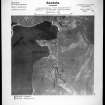
Sullom Voe seaplane Base is visible on Luftwaffe vertical air photographs dated 1940 and 1941, which show the base at an early stage of development. The image from 1940 annotates the area as 'flak' whilst that from 1941 shows that by this date the slipway, pier and several buildings/huts were in place.
A vertical air photograph taken after 1945 (RS: CPE/Scot/UK 285, 4432, flown 28 August 1947), shows the base at it's full extent. Three aircraft hangars are visible on the 1947 air photographs at c.HU 4015 7339, two are close together and a larger one is immediately to the N. Concrete tracks have been installed since the Luftwaffe image of 1941 along with hardstandings, huts and a second pier at the most northely point of Sella Ness. The two hangars close together have the appearance of being of the Bellman type.
The hangars have been removed as have all the huts and buildings and only the slipway and original pier survive. The pier visible at the northern tip of Sella Ness on the 1947 air photograph has also been removed.
Information from RCAHMS (DE), December 2005

