
Lerwick, Charlotte Street, Fort Charlotte


Artillery Fortification (17th Century), Drill Hall (20th Century)
Site Name Lerwick, Charlotte Street, Fort Charlotte
Classification Artillery Fortification (17th Century), Drill Hall (20th Century)
Alternative Name(s) Commercial Road; Harbour Street; Market Street; Territorial Army Headquarters
Canmore ID 1062
Site Number HU44SE 3
NGR HU 47552 41516
Datum OSGB36 - NGR
Permalink http://canmore.org.uk/site/1062


First 100 images shown. See the Collections panel (below) for a link to all digital images.
- Council Shetland Islands
- Parish Lerwick
- Former Region Shetland Islands Area
- Former District Shetland
- Former County Shetland
HU44SE 3 47552 41516
HU44SE 3.01 HU 47563 41556 North Barracks
HU44SE 3.02 HU 47566 41484 South Block
EXTERNALREFERENCE:
The Port is under the charge of the Commissioners of H.M.Works.
The National Library of Scotland hold a series of Military Maps and
Drawings (many coloured) of the Board of Ordnance, relating to the 18th
Century. Reference 'MSS. 1645-1652'.
Included in Case, or Volume, No 1649, are the following drawings of Fort Charlotte:-
Number. Year.
Z.3/48 1781 'Plan of Fort Charlotte, March 1781', and profiles.
Scale 100 feet to 2 inches. Signed Edinr, Jany 1783 by
A. Fraser. (2 copies)
Z.3/42 1783 'Plan of Fort Charlotte at Lerwick in Shetland Jany 1783'
With explanation. Scale 100 feet to 2 inches. Signed
Edinburgh January 1783 A. Frazer. 1 copy
Z.3/55 1783 'Plans, Section and Elevations, Barracks and Store Rooms,
Fort Charlotte, Shetland'. Scale 15 feet to 1 inch. Signed
Edinr Jany 1783 A. Frazer.
Z.3/44 1786 'Plans and Elevations of the Barracks at Fort Charlotte,
Scale, 15 feet to 1 inch. Docketted as'Brought by Major
Frazer Jany 1786'. (2 copies)
Z.3/44 1786 'Plans of buildings at Fort Charlotte, Shetland' Scale 10
feet to 1 inch. Docketted as 'Brought by Major Frazer '86'.
Note: Photostat copies of plans held in NMRS - 3 sheets
(Undated) information in NMRS.
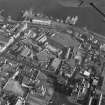
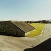
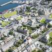
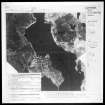
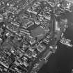
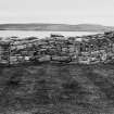
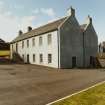
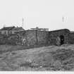
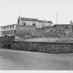
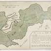
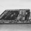
(HU 4755 4152) A. Fort Charlotte. A fort roughly pentagonal in shape with bastions projecting from each corner.
It is recorded that the fort was begun in 1665 to protect the Sound of Bressay against the Dutch. In 1673 it was burned with the town of Lerwick by the Dutch, but in 1781 it was repaired.
The north and south-west bastions have the appearance of early 17th century work and suggest the existence of a fort previous to that recorded.
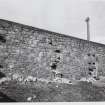
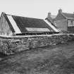
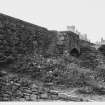
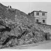
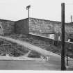
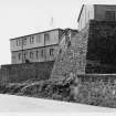
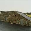
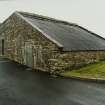
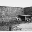
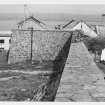
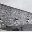
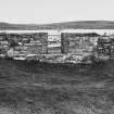
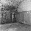
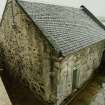
Although in the W and NW bastions there is evidence of rough course with pinnings, Fort Charlotte, which was built to house 300 men,appears to be an outstanding example of 18th century military architecture and still maintains its original pentagonal shape. All the bastions apart from the W and NW, already mentioned, have been repaired at various times. Of the original 25 gunports only 5 remain along the east bastion wall facing Bressa Sound. In addition to the three entrances shown on the plan of 1783 there is a small entrance in the NW wall. The fort was supplied with water from a 30ft deep timber framed well, still intact, though now unused.
Visible on GPs: A0/64/ 211-7-8 and GP: AO/64/202/2 and 3.
Visited by OS (RD) 7 September 1964.
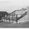
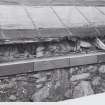
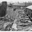
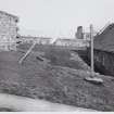
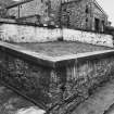
Due to the need for restoration of both rampart and gun platforms of the 18th-century fort along its seaward (eastern) defences, a limited programme of survey and excavation was completed in May 1993. In all, four gun platforms were completely excavated and a further two were partially revealed. It was found that the extensive remains of the platforms as well as the associated rampart, overlaid and were cut against an extensive earthwork, possibly part of the 17th-century fort, which was rebuilt in 1781.
In addition, a late 18th-century latrine channel was excavated but was found to contain exclusively modern debris over a modern wastepipe.
Sponsor: Historic Scotland.
G Ewart 1993k.
A second season of excavation and survey was completed along the seaward [eastern] battery of the fort. The sites of five gun platforms from the fort as laid out in the 1780s, were exposed and in general they confirmed the findings of the 1993 season. The extent of surviving 18th-century masonry and associated features varied considerably over the five sites, with those lying immediately to the SE of the Magazine being heavily disturbed. It is likely that a late 19th-century gun platform was constructed in this area, removing much of the 18th-century work, and this in turn was disturbed by a 20th-century building.
As in 1993, some evidence was found of a slumped earthwork against which the 1780s masonry was cut, and which appears to date from the earliest fort, built in the 1650s. Further evidence was also found to show that the 18th-century gun platforms were in fact of wood over a slightly raked mortared masonry base.
Sponsor: Historic Scotland.
G Ewart 1994e.
HU 476 415 Kirkdale Archaeology was contracted by Historic Scotland to expand two of their trenches in the NE corner of the battery from the 1994 season of excavation.The brief was to:
(a) extend trench 14 to the E by up to 2m to expose the footings of the masonry surrounding embrasure 1 and obtain a section through the remnants of the turf revetment and possible firing step to the E of the embrasure.
(b) extend trench 13 to the N by 1m to obtain a section through the remnants of the turf revetment and ?firing step to the N of embrasure 2 and to allow the ground level to be lowered in that area to a level consistent with the timber gun platform.
The excavations revealed that this NE corner of Fort Charlotte had been hugely disturbed by late Victorian and 20th-century activity. The remnants of the earlier turf revetments, although badly damaged by the use of this area, lay below the levels of the surfaces of the gun platforms and those required for the installation of new platforms, therefore remaining securely undisturbed by the current work on the battery. The revelation of the full extent of the embrasure in plan showed the possibility of slight variations in construction, a fact which was also reflected in the shapes and sizes of the gun platforms, with one example having sides more parallel than the usual wedge shape. It may be that the peculiarities in shape of this N facing platform and embrasure reflect some sort of structural necessity required in order to fit into this corner behind the magazine enclosure.
Sponsor: Historic Scotland
G Ewart and P Sharman 1996.
HU 476 415 A probe survey and investigative excavation down to bedrock were carried out during September 2006 in advance of consolidation work to secure the foundations of the curtain wall in response to concerns over structural integrity. A probe survey was carried out across the site to ascertain the depth of the bedrock. Four main trenches were opened, three against the E curtain wall and one against the W. A further six smaller trenches were opened to investigate the extent of deposits within the fort. Excavations revealed the earliest phase of construction - a 17th-century earth rampart as well as the earliest 17th- to early 18th-century curtain wall and subsequent phases of construction and demolition.
Archive to be deposited in NMRS.
Sponsor: Historic Scotland.
A Radley 2006.
Field Visit (18 March 1935)
Fort Charlotte, Lerwick. This fort, standing on a cliff beneath which the town of Lerwick has now extended, was ‘begun to be built in the time of the Dutch War, Anno 1665’ to protect Bressay Sound, ‘for then there was no town here’ (1). The ‘architector’ was ‘one Mr. Milne’ (2), i.e. John Mylne, the King's Master Mason. It was ‘burnt with the town of Lerwick by the Hollanders, August 13th, 1673’ (3), but in 1781 ‘it was repaired under the direction of Captain Fraser, Chief Engineer for Scotland, and called Fort Charlotte’ (4), after the then Queen.
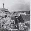
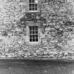
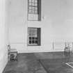
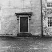
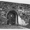
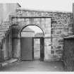
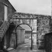
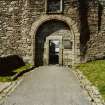
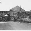
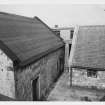
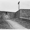
What has survived is an enclosure on Vaubanesque lines, over 2 acres in area and roughly pentagonal in shape, with bastions projecting from each corner. The wall is high and massive, and contains gun-ports looking seawards. There is an entrance on each side except the S.E., where the cliff is vertical. That on the N. has an unmoulded semi-circular arch, behind which there may originally have been a vaulted transe with a gatehouse above. The S. entrance, which projects slightly from the enclosing wall, is a lofty semi-circular archway, roll-moulded, once 9 ft. in width but subsequently reduced by the insertion of a doorway 2 ft. 6t in. wide; above it is the moulded border of an empty panel space. It opens into a transe vaulted with brick, over which there has been a ‘look-out’. The entrances on the W. and S.W. are small semi-circular archways, which may not be original.
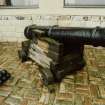
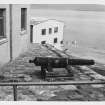
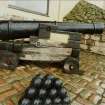
Two old guns from Fetlar, traditionally said to be relics of the Spanish Armada, are preserved inside. They are about 4 ft. 9 in. in length and have a bore of 2 ½ in.
RCAHMS 1946, visited 18 March 1935.
O.S.6"map, Shetland, 2nd ed.,(1902).
(1) Brand, Brief Description of Orkney, Zetland, &c. (1701), p. 88. (2) Gifford, Hist. Description of the Zetland Islands, p. 6. (3) Sibbald, Description, p. 5. According to Brand, as cited above, there was ‘within the walls a House of Guard, which hath been two Stories high, burnt by the Dutch, after that our Soldiers had left the Fort’. (4) Stat. Acct., iii, p. 420.
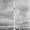
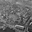
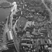
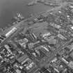
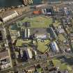
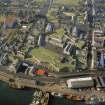
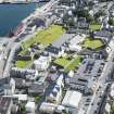
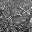
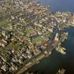
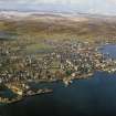
Aerial Photography (1971)
Oblique aerial photographs of Fort Charlotte, Lerwick, taken by Mr John Dewar in 1971.
Excavation (5 July 1993 - 11 July 1993)
HU 476 415 Due to the need for restoration of both rampart and
gun platform of the 18th-century fort, along its seaward (eastern)
defences, a limited programme of survey and excavation was
completed in May 1993. In all, four gun platforms were completely
excavated and a further two were partially revealed. It was found
that the extensive remains of the platforms as well as the associated rampart, overlaid and were cut against, an extensive earthwork,
possibly part of the 17th-century fort, which was rebuilt in 1781,
In addition, a late 18th-century latrine channel was excavated but
was found to contain exclusively modem debris over a modern
wastepipe.
G Ewart 1993
Sponsor: Historic Scotland
Kirkdale Archaeology
Excavation (5 June 1994 - 1 July 1994)
A second season of excavation and survey was completed along the seaward [eastern] battery of the fort. The sites of five gun platforms from the fort as laid out in the 1780s, were exposed and in general they confirmed the findings of the 1993 season. The extent of surviving 18th-century masonry and associated features varied considerably over the five sites, with those lying immediately to the SE of the Magazine being heavily disturbed. It is likely that a late 19th-century gun platform was constructed in this area, removing much of the 18th-century work, and this in turn was disturbed by a 20th-century building.
As in 1993, some evidence was found of a slumped earthwork against which the 1780s masonry was cut, and which appears to date from the earliest fort, built in the 1650s. Further evidence was also found to show that the 18th-century gun platforms were in fact of wood over a slightly raked mortared masonry base.
G Ewart 1994
Sponsor: Historic Scotland
Kirkdale Archaeology
Kirkdale Archaeology
Excavation (June 1996)
HU 476 415 Kirkdale Archaeology was contracted by Historic Scotland to expand two of their trenches in the NE corner of the battery from the 1994 season of excavation.The brief was to:
(a) extend trench 14 to the E by up to 2m to expose the footings of the masonry surrounding embrasure 1 and obtain a section through the remnants of the turf revetment and possible firing step to the E of the embrasure.
(b) extend trench 13 to the N by 1m to obtain a section through the remnants of the turf revetment and ?firing step to the N of embrasure 2 and to allow the ground level to be lowered in that area to a level consistent with the timber gun platform.
The excavations revealed that this NE corner of Fort Charlotte had been hugely disturbed by late Victorian and 20th-century activity. The remnants of the earlier turf revetments, although badly damaged by the use of this area, lay below the levels of the surfaces of the gun platforms and those required for the installation of new platforms, therefore remaining securely undisturbed by the current work on the battery. The revelation of the full extent of the embrasure in plan showed the possibility of slight variations in construction, a fact which was also reflected in the shapes and sizes of the gun platforms, with one example having sides more parallel than the usual wedge shape. It may be that the peculiarities in shape of this N facing platform and embrasure reflect some sort of structural necessity required in order to fit into this corner behind the magazine enclosure.
G Ewart and P Sharman 1996
Sponsor: Historic Scotland
Kirkdale Archaeology
Publication Account (1997)
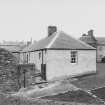
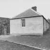
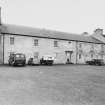
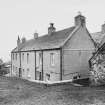
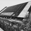
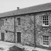
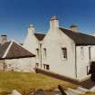
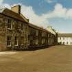
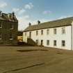
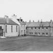
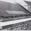
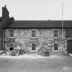
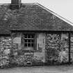
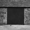
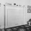
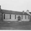
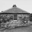
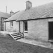
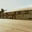
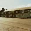
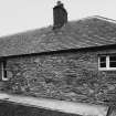
The substantial remains of this impressive fort have been surrounded by modern Lerwick, but, when it was built in the 17th century, it stood isolated and forbidding on a cliff to the north of the village, with its gun-ports looming over Bressay Sound. Because its fire-power had to be concentrated along its east side, the plan of the fort is less regularly geometric on plan than was normal; it is roughly pentagonal, with a massive seaward wall which is angled rather than straight in order to increase the range of the nine gun-ports massed along it. Each of the five bastions set at the angles of the rest of the fort-wall was also provided with gun-ports, up to a maximum of five in the west bastion. Although the building of the fort began in 1665 (designed by no less a man than John Mylne, Master Mason to King Charles I1), it was burnt by the Dutch in 1673 and lay in disrepair for more than a century until 1782 when it was renovated by the Chief Engineer for North Britain and renamed Fort Charlotte in honour of the Queen. The 18th-century fort had three gates, with the main gate between the west and south-west bastions, and a gun-track led from the north gate out to the Knab headland, the first formal road to be built in Shetland. Within the fort, on three sides of a central parade-ground, were built accommodation blocks. The main west block provided barracks for the garrison, with officers' quarters in the projecting bays at either end, the north block consisted of ground-level kitchen and stores and first-floor accommodation for the Commanding Officer, and the south block held guard-rooms and artillery stores.
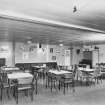
For a time in the mid 19th century, Lerwick's prison was within the fort buildings. Between 1881 and 1910, Fort Charlotte acted as a training centre for the Royal Naval Reserve, providing a reserve body of seamen trained in gunnery. The fort was 'rearmed' in 1995, when Historic Scotland installed four replica 18-pounder cannons of 18th-century type on the original gun-platforms. The Shetland Field Studies Trust is now housed in the old fort, with a small display of natural history.
Information from ‘Exploring Scotland’s Heritage: Shetland' (1997).
Excavation (11 September 2006 - 29 September 2006)
HU 476 415 A probe survey and investigative excavation down to bedrock were carried out during September 2006 in advance of consolidation work to secure the foundations of the curtain wall in response to concerns over structural integrity. A probe survey was carried out across the site to ascertain the depth of the bedrock. Four main trenches were opened, three against the E curtain wall and one against the W. A further six smaller trenches were opened to investigate the extent of deposits within the fort. Excavations revealed the earliest phase of construction - a 17th-century earth rampart as well as the earliest 17th- to early 18th-century curtain wall and subsequent phases of construction and demolition.
A Radley 2006
Sponsor: Historic Scotland
Kirkdale Archaeology
Excavation (4 December 2007 - 15 February 2008)
HU 476 415 A programme of excavation and monitoring was undertaken from 4 December 2007–15 February 2008, in advance of and during intrusive works near and under the E battery wall. This was the latest phase in a series of works started in 1992. Earlier visits had located and recorded the remains of 18th-century gun platforms hidden below the current turf level and it was necessary to carry out further minor excavation, both to locate the previously excavated platforms and to reveal the northern limit of one partially revealed platform. This was followed by more substantial excavation to allow the insertion of reinforced concrete piles and underpinning under the E battery wall. Since much of the area had been examined in some detail during previous excavations, this latest work did not add a great deal to the interpretation of the sequence of construction in this part of Fort Charlotte. The deliberate avoidance of the more significant structures (gun platforms) also made any new archaeological discoveries less likely. There was no new evidence of the earliest phases.
Archive: RCAHMS (intended)
Funder: Historic Scotland
Gordon Ewart (Kirkdale Archaeology), 2008
Excavation (18 June 2007 - 23 June 2007)
Along the E rampart of the fort, a series of trial trenches were excavated between 18 June–23 June 2007 in order to confirm the locations of eight of the 18th-century gun platforms serving the E Battery. In addition, the archaeological potential of a range of other structures along the E rampart based on historic plan evidence , was checked. These included 18th-century earthworks and 20th-century huts. A total of eight trenches were excavated which successfully confirmed the sites of the gun platforms and some evidence , in terms of levelling and clearance activity of the hut sites. No upstanding evidence was found of the 18th-century
earthworks which once separated the gun platforms.
Archive to be deposited with RCAHMS.
Funder: Historic Scotland.
OASIS ID: kirkdale1-31069
Watching Brief (28 February 2009 - 1 March 2009)
HU 475 415 A watching brief was carried out 28 February to 1 March 2009 on the excavation of a series of trenches at Fort Charlotte. Seven small trenches were opened during a search to locate and seal a burst water pipe. Modern paving slabs and recently disturbed deposits were noted but no finds or features of archaeological significance were recorded.
Archive: RCAHMS (intended)
Funder: Historic Scotland
Information from Andrew Hollinrake (Kirkdale Archaeology) 8 April 2010 . OASIS ID - kirkdale1-249674
Watching Brief (15 August 2011 - 27 August 2011)
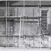
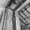
HU 4751 4151 Two test trenches were excavated 15–27 August 2011 in the W bastion of Fort Charlotte. Structural cracks and voids had been noted within the N and W walls of the bastion and the two trenches were manually excavated to examine the composition of the wall and underlying ground, and to ascertain the cause of the problem. This work formed part of an on-going programme of investigation and repair at the fort, which has seen the examination and resolution of problem areas in the other bastions, mainly those to the N and E.
Previous excavations in the E bastion showed that shrinkage of the 17th-century earthwork and the resultant void between it and the 18th-century masonry walls had caused structural instability, severe cracking and partial collapse of the wall. This work in the W bastion showed that although a partial, but largely negligible, void existed in places between the masonry wall and the earthwork, the present structural issues originated in the later addition of poorly bonded masonry.
Archive: RCAHMS (intended)
Funder: Historic Scotland
Kirkdale Archaeology, 2011
Excavation (21 November 2011 - 24 April 2012)
HU 4752 4152 Following test trenching in 2011 (DES 2011, 172), to examine structural cracks and voids that had been noted within the N and W walls of the bastion, a further programme of test trenches and standing building recording was completed over four main stages from November 2011 to April 2012 while consolidation of the walls was completed.
Previous excavations in the E bastion showed that shrinkage of the 17th-century earthwork and the resultant void between it and the 18th-century masonry walls had caused structural instability, severe cracking and partial collapse of the wall. The test trenches in the W bastion showed that although a partial, but largely negligible, void existed in places between the masonry wall and the earthwork, the present structural issues originated in the later addition of poorly bonded masonry. While the W bastion is being compressed, due to the failure of parts of the masonry structure, the buried earthwork seems to provide it with a reasonably solid structural backing.
The problems of structural cracking at the fort stem from two main sources. Firstly, the creation of a thickened cope-topped cap around the fort walls, which may have been added for safety or perhaps to improve the security of the fort. Evidence in the W bastion indicates that this process started from the S and moved N. To the S, the added face bonds into the battered rear face of the scarp wall and is seated on bedrock. Secondly, the bedrock falls away rapidly to the N, leading to a decision to simply dig into the peat bank and apply a foundation, onto which the added wall face could sit, rather than take the added wall face down to bedrock. Whether it was a question of speed, cost, time or availability of materials, it resulted in the thickened wall top being carried on a wall which was voided to the rear and was in turn carried by a bonded foundation based on a truncated peat bank. The slippage of the foundations and the lack of a bond to the existing battered rear wall led to the structural failures.
Archive: RCAHMS (intended)
Funder: Historic Scotland
Paul Fox, Kirkdale Archaeology 2012
OASIS Id: kirkdale1-310855

