
Kebister


Mound (Period Unassigned), Settlement (Period Unassigned)(Possible)
Site Name Kebister
Classification Mound (Period Unassigned), Settlement (Period Unassigned)(Possible)
Canmore ID 1022
Site Number HU44NE 9
NGR HU 4561 4539
Datum OSGB36 - NGR
Permalink http://canmore.org.uk/site/1022


- Council Shetland Islands
- Parish Tingwall
- Former Region Shetland Islands Area
- Former District Shetland
- Former County Shetland
HU44NE 9 456 454
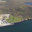
Situated 120m SW of Kebister settlement (HU44NE 5) is a mound with protruding orthostats, probably a prehistoric house.
O Owen and C Lowe 1987.
The structure (Structure 19 in the published report) lies some 25m from the shore, in an enclosed post-medieval field (see HU44NE 10). It is visible as a roughly circular, grass-covered mound, 10-12m across and standing 1m high on the W. Its upper surface is relatively level and defined to the S by three large orthostats, together with a low ridge. The E side has been damaged by later cultivation. Three test pits were excavated in its top. In Trench 1, a deposit of cultivated soil, 0.45m thick, overlay the archaeological deposits, including traces of burning. In Trench 2 a wall-face of roughly dressed stone slabs was exposed. No archaeological depostits were encountered on the E side of the mound (Trench 3). The structure is interpreted as a prehistoric house similar in form and size to the Iron Age oval stone house excavated in the main trench at HU44NE 5.
O Owen and C Lowe 1999.
The excavation archive from Kebister has been catalogued. The archive consists of manuscripts, photographic material and drawings. Digital and audio archive is available and consists of drafts of the Kebister 1999 monograph, the stone catalogues, the key for the soil maps, mini data cartridges containing 'Kebister modified files' and a recorded conversation with Mr and Mrs Anderson.
Historic Scotland Archive Project (SW) 2001

