
Southvoe


Broch (Iron Age)(Possible), Settlement (Iron Age)(Possible)
Site Name Southvoe
Classification Broch (Iron Age)(Possible), Settlement (Iron Age)(Possible)
Canmore ID 916
Site Number HU41SW 2
NGR HU 40029 14724
Datum OSGB36 - NGR
Permalink http://canmore.org.uk/site/916


- Council Shetland Islands
- Parish Dunrossness
- Former Region Shetland Islands Area
- Former District Shetland
- Former County Shetland
HU41SW 2 4003 1472.
(HU 4001 1473) Brough (OE) (Site of)
OS 6" map, Shetland, 2nd ed., (1903).
The grass-covered remains of a broch. Only very fragmentary traces of the main building can now be identified, but these indicate that it was entered from the SW through a passage, three lintel stones of which still remain in position. The internal diameter is about 27' and the wall is about 15' thick at the entrance. Excavation would probably reveal at least 6 or 7' of structure still standing on the seaward side, where the mound is highest. To the westward side the remains are low and merge into the sloping hillside, while beyond them are traces of numerous out-buildings. The remains of a wall are visible all along the edge of the cliff. A good harbour for small craft, easily accessible from the broch, is found by a narrow lane of water almost immediately in front of the broch.
RCAHMS 1946, visited 1930.
As described by the RCAHMS.
Surveyed at 1/2500.
Visited by OS (NKB) 18 May 1968.
Field Visit (2 September 1930)
Broch, Southvoe. Not far from the edge of the cliffs at Bu Taing, near Southvoe, are the grass-covered remains of a broch. Only very fragmentary traces of the main building can now be identified, but these indicate that it was entered from the S.W. through a passage, three lintel stones of which still remain in position. The internal diameter is about 27 ft, and the wall is about 15 ft thick at the entrance. On the N. segment of the inner face, two stones, set upright at a distance of 2 ft. 8 ins. apart, may possibly indicate an opening in the wall at some height above the floor. No other features of interest are exposed, but excavation would probably reveal at least 6 or 7 ft. of structure still standing on the seaward side, where the mound is highest. To the western or landward side the remains are low and merge into the sloping hillside, while beyond them are numerous traces of ‘out-buildings’. The remains of a wall are visible all along the edge of the cliff. It is worth adding that almost immediately in front, a long, high ridge of rock runs parallel to the shore, leaving a narrow lane of water, which would form a good natural harbour for small craft and would be easily accessible from the broch. Such an association is somewhat unusual, although it occurs elsewhere, e.g. at Clevigarth (HU41SW 3).
RCAHMS 1946, visited 2 September 1930.
OS 6" map, Shetland, 2nd ed., (1903).
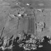
Aerial Photography (October 1973)
Oblique aerial photographs of Southvoe broch, Shetland, photographed by John Dewar in 1973.
Publication Account (2002)
HU41 6 SOUTHVOE
HU/400147
A probable broch in Dunrossness, standing near the edge of cliffs and in a dilapidated condition. Few of the structural features can be made out. The entrance passage is on the SW and has three lintel stones in position. The internal diameter is about 27 ft. and the wall about 15 ft. thick: thus the wall proportion may be about 52.6%. There is a possible opening in the inner wall face in the inner wall face in the north segment. There are numerous traces of outbuildings and a good natural harbour is close by.
Sources: 1. OS card HU 41 SW 2: 2. RCAHMS 1946, vol. 3, no. 1142, 23-4.
Field Visit
The broch stands on a broad platform or raised area, surrounded by the remains of at least six other buildings. These structures are not clearly defined and are largely visible as shallow depressions. They have been described individually below, but it is probable that some may originally have been conjoined. There are indications that the settlement was surrounded by a curvilinear enclosure bank. (i) The grassy broch mound is located on the coast edge. It is about 15m in diameter and survives to a height of about 2.5m. Some stonework is visible in a series of small exposures which are located towards the base of the broch on the NW side. (ii) To the SE side of the broch, an oval structure is eroding from the coast edge. Visible as a slight depression with portions of coursed walling exposed, it measures 3m in width and survives to a length of 6m. (iii) To the SW side of the broch, a second structure has a subrectangular or oval form. It measures 5m by 6m and is defined by a slight earthen bank with occasional stones protruding. (iv) A poorly defined circular structure, 6m in diameter, is located to the W side of the broch. (v) A circular structure lying between structures (iii) and (iv) is visible as a shallow depression 6m in diameter. Remnants of an internal stone facing survive. (vi) To the NNW side of the area, a circular structure visible as a shallow depression measures 6m in diameter. (vii) An oval structure lies to the N side of the area. It measures 6m in length by 3m in width and is visible as a shallow depression.
Visited by Scotland's Coastal Heritage at Risk (SCHARP)

