
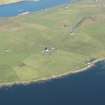
Sand, St Mary's Chapel And Churchyard


Chapel (Medieval), Churchyard (Medieval) - (Post Medieval)
Site Name Sand, St Mary's Chapel And Churchyard
Classification Chapel (Medieval), Churchyard (Medieval) - (Post Medieval)
Canmore ID 703
Site Number HU34NW 3
NGR HU 34673 47213
Datum OSGB36 - NGR
Permalink http://canmore.org.uk/site/703


- Council Shetland Islands
- Parish Sandsting
- Former Region Shetland Islands Area
- Former District Shetland
- Former County Shetland
Field Visit (26 June 1931)
St. Mary's Chapel, Sand.
All that is left of this chapel is the semi-circular chancel arch which finishes in a gable and may be of late 16th-century date. It is built of rubble with mortar, has triangular keystones, and is 2 ft. 10 in. in thickness, the outer returns between nave and chancel having apparently been buttressed at a later time. It measures 8 ft. 4 in. in width, 7 ft. 2 in. in height to the springers, and 10 ft. 2 in. from the present ground-level to the soffit of the crown. The lengths of nave and chancel are unobtainable, but the nave has been 12 ft. wide and the chancel presumably of the same width as the arch. A raggle on the E. side of the arch gable indicates that the chancel has had a lower roof than the nave.
Without giving any authority for his statement, Hibbert (1822) describes the building as "the ruins of a very neat chapel erected by the Spaniards during the time they were detained in Shetland; it was originally dedicated by them to St. Mary, as a tribute of gratitude to the Virgin for their preservation on the hospitable shore of Thule” (1). T. S. Muir, on the other hand, held that “there cannot be a doubt of its being older by some hundreds of years than the end of the sixteenth century” (2).
RCAHMS 1946, visited 26 June 1931.
(1) Description, p. 454.
(2) Ecclesiological Notes on Some of the Islands of Scotland, p. 172.
OS 6" map, Shetland, 2nd ed. (1903)
Field Visit (6 June 1968)
HU34NW 3 34672 47217
(HU 3466 4722) St. Mary's Chapel (LB) (In Ruins)
OS 6" map, Shetland, 2nd ed. (1903)
As described.
Published Survey (25") correct.
Visited by OS (RL), 6 June 1968.

