
Hamnavoe, The Giant's Stones


Standing Stone(S) (Prehistoric)
Site Name Hamnavoe, The Giant's Stones
Classification Standing Stone(S) (Prehistoric)
Alternative Name(s) Grind Hill
Canmore ID 508
Site Number HU28SW 3
NGR HU 24301 80551
NGR Description HU 24301 80551 and HU 24322 80556
Datum OSGB36 - NGR
Permalink http://canmore.org.uk/site/508


- Council Shetland Islands
- Parish Northmavine
- Former Region Shetland Islands Area
- Former District Shetland
- Former County Shetland
Field Visit (4 August 1931)
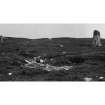
"The Giants' Stones," Grind Hill, Hamnavoe.
These two standing stones (Fig. 593) rise amid bleak moorland surroundings on the S side of Grind Hill about 650 yds E of the township of Hamnavoe. They have been erected at an elevation of roughly 100 ft. above sea-level, on a line lying almost due E and W, and are 67 ft. apart. The more easterly, which is set with its major axis WNW and ESE, has a pointed top, with a maximum height of 5 ft 7 in, and is rectangular at the base, where it measures 5 ft. by 1 ft. 5 in. Its companion, which stands with its major axis SW and NE, is higher, the top being 7 ft. 7 in. above the ground. It measures 4 ft. 2 in. by 21 in. at the base, but tapers gradually upwards. According to Low (1) there was formerly a third stone.
RCAHMS 1946, visited 4 August 1931.
OS 6" map, Shetland, 2nd ed., (1900)
(1) Tour, p. 137.
Field Visit (23 April 1969)
HU28SW 3 2430 8055 and 2431 8055.
(HU 2432 8055 ) The Giants' Stones (O.E.).
OS 6" map, Shetland, 2nd ed., (1900)
The Giants' Stones, as described by RCAHMS.
Divorced Survey at 1/10,000.
Visited by OS (R L) 23 April 1969
Note (September 1972)
A S Henshall. has inferred that stumps of other stones exist - to suggest a Stone Circle.
Information from A S Henshall to OS, September 1972.
Publication Account (1997)
These two stones are set 20m apart in an east-west line, but a third stone was recorded in 1774 and its relationship to the two surviving stones is not known. These are impressive stones at 1.8m and 204m tall, but there is no obvious reason for their location on this hillside. Their rest ricted visibility from the voe below means that they are unlikely to have been used as sea-marks.
Information from ‘Exploring Scotland’s Heritage: Shetland’, (1997).

