
Papa Stour, Meal Road, Mill Knowe To Setter


Road (Period Unassigned)
Site Name Papa Stour, Meal Road, Mill Knowe To Setter
Classification Road (Period Unassigned)
Canmore ID 113873
Site Number HU16SE 48
NGR HU 1634 6061
NGR Description HU 1634 6061 to HU 1711 6038
Datum OSGB36 - NGR
Permalink http://canmore.org.uk/site/113873

- Council Shetland Islands
- Parish Walls And Sandness
- Former Region Shetland Islands Area
- Former District Shetland
- Former County Shetland
HU16SE 48 1634 6061 to 1711 6038
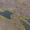
The monument consists of a stretch of 'meal' road, a track built as part of a 19th-century famine relief scheme. Flour or 'meal' was given as payment for the construction of these roads, which were often not strictly necessary, to avoid the stigma of charity.
There were many stretches of road and track built in various famine relief schemes throughout the Highlands and Islands in the mid to late 19th Century, but very few survive in good condition without modern resurfacing. The survival of the Papa Stour examples (HU16SE 47 and HU16SE 48 ) can probably be attributed to their narrow gauge (designed for small carts and pack ponies rather than larger waggons) which prevented their being easily made up to motor roads, and simply the scarcity of motor transport on the small island into recent years.
This stretch is one of the two best-preserved. It runs for almost 850m, and gave improved access from Hamnavoe and the mills at Dutch Loch to Setter and the main settlement area of the island. It is formed of small stones carefully laid between two edging kerbs of larger blocks, and is flanked where necessary with shallow surface drainage ditches. It crosses a number of small water courses, two of which are bridged by culverts formed by large lintel stones. The width of the track is approximately 3m, but is slightly variable.
Information from Historic Scotland, scheduling document dated 17 September 1996.

