
Unst, North-house


Farmstead (Period Unassigned)
Site Name Unst, North-house
Classification Farmstead (Period Unassigned)
Canmore ID 188662
Site Number HP60SW 46
NGR HP 61654 03052
Datum OSGB36 - NGR
Permalink http://canmore.org.uk/site/188662


- Council Shetland Islands
- Parish Unst
- Former Region Shetland Islands Area
- Former District Shetland
- Former County Shetland
HP60SW 46 6163 0304
A farmstead comprising one unroofed L-shaped building, one unroofed structure and two enclosures, and a head-dyke are depicted on the 1st edition of the OS 6-inch map (Orkney and Shetland (Shetland) 1881, sheet viii) and on the current edition of the OS 1:10000 map (1973).
Information from RCAHMS (SAH) 6 February 2001
Field Visit (January 1970 - December 1991)
A survey of deserted settlements in Unst by June Owers. The survey includes photographs, sketches and historical information.
Field Visit (24 April 2010)
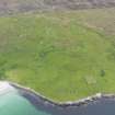
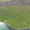
This farmstead stands in semi-improved pasture 300m E of the Wick of Smirgirt. It comprises four buildings and a number of linked enclosures extending ENE and S. The best preserved building is a range (HP 61636 03048) which measures about 10.5m from NNW to SSE by 4.5m transversely over roughly coursed rubble walls that still stand to wall-head height. There is a blocked window and a central entrance in the ENE side and a fireplace in the SSE gable. In addition, there is an outshot at the NNW end, which was used as a byre, and another attached to the ENE side. Two further buildings are situated within the trapezoidal enclosure which forms the most northerly of the cluster. Both are reduced to their footings and occupy its SE corner, but the more northerly (HP 61667 03058) measures about 16m from ENE to WSW and 5m transversely, while its neighbour (HP 61670 03053) measures about 15m from ENE to WSW and 5m. This contains two compartments of different sizes and its SSE wall underlies that of the later enclosure. A fourth building (HP 61654 03052) is situated just to the S of the SSE corner of the enclosure. It measures about 15m from ENE to WSW by 4m over grass-grown footings and there is an entrance in its SSE side.
The E range is shown roofed on the 1st edition of the OS 6-inch map, but unroofed on the 2nd edition of the map (Shetland 1882 and 1902, Sheet VIII). The other buildings are not shown on either map.
Visited by RCAHMS (DCC) 24 April 2010
Srp Note (27 September 2011)
A plan of North-House was sketched by June Owers in her survey of abandoned settlements on Unst (1984).
Information from RCAHMS (BRW) 27 September 2011

