
Unst, Underhoull


Cist(S) (Period Unassigned), Dyke (Period Unassigned)
Site Name Unst, Underhoull
Classification Cist(S) (Period Unassigned), Dyke (Period Unassigned)
Canmore ID 32
Site Number HP50SE 13
NGR HP 575 045
Datum OSGB36 - NGR
Permalink http://canmore.org.uk/site/32


- Council Shetland Islands
- Parish Unst
- Former Region Shetland Islands Area
- Former District Shetland
- Former County Shetland
HP50SE 13 575 045.
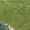
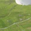
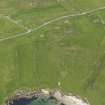
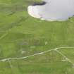
(Area: HP 575 045) There is a place in Unst, near the broch of Underhoul, where what appears to be the outer dyke of an old town can be traced.... a short time ago while a party of workmen were engaged in the construction of a road inside this old dyke, a burial place was discovered, in which were found three graves, each enclosed by four rough stone slabs. No human remains were found, but each cist contained a mortar and a lamp, both of stone. The mortar was smaller than the old "knockin' stane," and by its shape and wear seemed adapted for holding between the knees of the operator when being used. The inside hollow was capable of holding two pounds of meal. The "lamp", was a bit of stone hollowed out like a saucer - just a stone "collie". It looks as if it had been saturated with oil, and bore traces of the action of fire (Spence 1899).
RCAHMS 1946; J Spence 1899.
It seems possible that the dyke referred to may be that which is shown on the OS 6" map as running SE then NNW from the defences of the broch of Underhoull (HP50SE 12).
OS(ES) 28 November 1968.
No further information. Numerous old field dykes in the area.
Visited by OS(NKB) 5 May 1969

