
Yell, Burgi Geos


Promontory Fort (Prehistoric)
Site Name Yell, Burgi Geos
Classification Promontory Fort (Prehistoric)
Canmore ID 4
Site Number HP40SE 1
NGR HP 4781 0338
Datum OSGB36 - NGR
Permalink http://canmore.org.uk/site/4


- Council Shetland Islands
- Parish Yell
- Former Region Shetland Islands Area
- Former District Shetland
- Former County Shetland
HP40SE 1 4781 0338
(HP 4779 0344) Brough (NR).
OS 6" map, Shetland, 2nd ed., (1909).
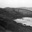
The outer is a wall of large, independent, set stones which from afar give the impression of a rather coarse 'chevaux de frise'. Behind this the tail of the promontory is defended by the 'block-house' wall, 35' long and 13' thick. The entrance passage appears to have been at the southern extremity of this wall. A fragment of a rough retaining wall which has apparently been carried round the top of the cliffs is still identifiable.
RCAHMS 1946
A 'block-house' fort on a precipitous promontory, across the neck of which two lines of defence have been drawn.
R W Feacham 1963
As described.
Visited by OS (RL) 11 May 1969.
Scheduled as Burgi Geos, promontory fort... a promontory fort of later prehistoric, perhaps Iron Age, date.
Information from Historic Scotland, scheduling document dated 13 May 2006.
Note (26 February 2016 - 16 November 2016)
This fort stands on a precipitous promontory on the NW coast of the island of Yell, in what is today one of the most remote spots in the British Isles. Approached from the E, the entrance way leading onto the narrow isthmus is lined for a distance of about 8m on the N by a row of slabs, perhaps the revetment of a wall that has slipped over the cliff, while on the S it is flanked by a mound studded with upright stones, apparently forming a chevaux de frise rather than the remains of any structure. From there the path descends to a narrow rocky neck, before climbing to confront the inner defences, comprising a rectangular blockhouse set slightly to one side, with a walled enclosure to its rear. The blockhouse measures 6.7m in length by 4.25m in breadth, and the enclosure to its rear, which is only some 12m across overall, is apparently butted on at the NE and SW corners respectively. No entrance is visible into the blockhouse, which is positioned to allow access between its S end and the cliff-edge to the seaward end of the promontory. There, at the edge of its S side, Raymond Lamb recovered two sherds of pottery from the cliff section and evidence of occupation in the bottom of a shallow hollow which he interpreted as the remains of a round building; he also observed traces of several other similar hollows, though these do not appear on his plan. The summit of the promontory has evidently been reduced by erosion and the irregular area to the rear of the blockhouse barely measures 22m from E to W by 10m transversely (0.02ha).
Information from An Atlas of Hillforts of Great Britain and Ireland – 16 November 2016. Atlas of Hillforts SC4169

