
Pattiston, Millthird, Lochliboside Hills


Anti Aircraft Battery (20th Century)
Site Name Pattiston, Millthird, Lochliboside Hills
Classification Anti Aircraft Battery (20th Century)
Alternative Name(s) S14; Clyde Aa Defences; Pattiston; Ailsa View Caravan Site
Canmore ID 98904
Site Number NS45NE 39
NGR NS 4523 5719
Datum OSGB36 - NGR
Permalink http://canmore.org.uk/site/98904


- Council East Renfrewshire
- Parish Neilston (Renfrew)
- Former Region Strathclyde
- Former District Renfrew
- Former County Renfrewshire
NS45NE 39 4523 5719
An anti-aircraft battery is depicted on the latest edition of the OS map (OS 1:10000 map, 1985) within the Ailsa View Caravan Site.
Information from RCAHMS (DE) 23 April 1996
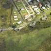
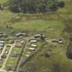
This battery is located on the N side of the A736 public road. The battery as originally built, housed four 3.7/4.5-inch guns with the 5.25-inch battery being built to the SW. The gun emplacements and their command post have now been demolished to make plots for caravans, the only structure found of this battery was the Gun Laying radar platform.
Information from Mr J Guy August 1996
Recorded as part of Mr J Guys Strathclyde Survey.
J Guy 2001; NMRS MS 810/11, Part 2, 173-4
Vertical air photographs taken in 1946 (106G/Scot/UK 84, 3325-3327, flown 10 May 1946), show the World War Two date heavy anti-aircraft battery at this location. Four gun-emplacements with the command position, an arc of huts to the NE and a line of hut bases on the S side of the road and the radar unit, GL-mat to the N.
A series of vertical air photographs taken almost eight years later (F22/RAF/932, 0460-0462, flown 31 May 1954) show the postwar four emplacement anti-aircraft battery (NS45NE 40), has been built immediately to the SW of the four WW II emplacements and does not overlie them. The cable trenches from the postwar battery have encroached over the area formerly taken by the GL-mat.
No additional accommodation for the postwar battery is visible on the later series of air photographs.
Information from RCAHMS (DE), June 2006.
The concrete gun laying radar platform (radar ramp) has been identified from oblique aerial photographs taken in September 2007 (RCAHMS 2007) on the N side of the site at NS 45181 57242.
Information from RCAHMS (DE), December 2007.
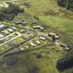
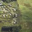
On the date of visit no evidence of the World War II anti-aircraft battery was found in an area now occupied by a static caravan park. However, the postwar four emplacement anti-aircraft battery (NS45NE 40) is extant.
Visited by RCAHMS (AGCH) 5 June 2007.
Field Visit (5 June 2007)
On the date of visit no evidence of the World War II anti-aircraft battery was found in an area now occupied by a static caravan park. However, the postwar four emplacement anti-aircraft battery (NS45NE 40) is extant.
Visited by RCAHMS (AGCH) 5 June 2007.
Field Visit (6 July 2017)
This heavy anti-aircraft battery is situated on the summit of a hill within the Heather Bank Park residential estate, but only the gun laying radar platform and the concrete floor of one of the camp buildings survive. In addition, there is a length of a roadway that is not visible on the RAF vertical aerial photographs (106G/Scot/UK 84, 3325-3327) flown on 10 May 1946, and must therefore have been built later. It was one of at least 43 such batteries that were constructed to protect the industries in the centre of Glasgow and along the banks of the River Clyde from aerial attack by the Luftwaffe during WWII.
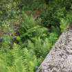
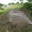
The gun laying radar (NS 45181 57242), which was once located at the centre of a GL mat, now lies in dense vegetation about 50m ENE of the most northerly of the four Cold War gun-pits (NS45NE 40). The wire mesh is missing, but the cement-washed, brick walls of the ramp running up to the concrete-capped platform are extant. Unusually, this platform is raised over a hollow compartment which was accessed by a door on the NE.
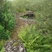
The concrete base of one camp building (NS 045395 57192) is situated immediately NW of the triangular plantation that lay SE of the battery, on the verge of a road providing access to a crescent of bungalows. It is rectangular on plan and measures 9.35m from NE to SW by 2.2m transversely. A ramp at the SW end hints at the location of an entrance, while a large dump of broken concrete to the SE is all that is left of the building’s neighbours.
The road, which is of concrete with narrow moulded kerbs to each side, runs from NE to SW (NS 45332 57232 to NS 45305 57209) for about 35m and now serves some of the bungalows on the hill top. Its character and orientation suggest that it may have been constructed to afford access to the four gun-pits and the command post.
Visited by HES, Survey and Recording (ATW, ARG) 6 July 2017

