
Tournaig Farm


Anti Aircraft Battery (20th Century), Military Camp (20th Century)
Site Name Tournaig Farm
Classification Anti Aircraft Battery (20th Century), Military Camp (20th Century)
Alternative Name(s) E3; Loch Ewe Defences
Canmore ID 98096
Site Number NG88SE 26
NGR NG 87527 83797
Datum OSGB36 - NGR
Permalink http://canmore.org.uk/site/98096


- Council Highland
- Parish Gairloch
- Former Region Highland
- Former District Ross And Cromarty
- Former County Ross And Cromarty
NG88SE 26.00 87527 83797
NG88SE 26.01 c.NG 8751 8355 Radar site
An anti-aircraft battery which is depicted on the OS 1:10560 map (1969) 150m NW of Tournaig Farm.
Information from RCAHMS (DE) 16 April 1996
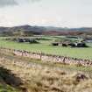
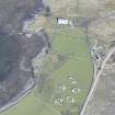
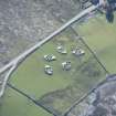
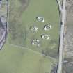
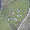
This heavy anti-aircraft battery is situated in a field between the B832 road and the shore some 200m NE of Tournaig farmsteading. All four gun-emplacements and the command post are extant. Examination of the brick and concrete gun emplacements reveals that all show evidence of having been modified to take another type of weapon. The battery was armed in World War II with 4 x 3.7-inch guns.
J Guy 2000; NMRS MS 810/10, Vol.1, 47, Vol.3, 26-7
The heavy anti-aircraft battery lies to the W of the A832 road N of Tournaig farmsteading. The four gun-emplacements and the command post are all extant. All four emplacements have a brick built platform within the ring of ready-use ammunition lockers. They are about 1m high and slope towards the entrance. In the top of one of the platforms are traces of four circular depressions, whilst the top of the other platforms show similar indentations.
The RAF vertical air photographs (CPE/Scot/UK182, 4334-4335, flown 8 October 1946) do not clearly show the platforms or what they may have been built for.
The accommodation camp was situated immediately S (c. NG 8756 8360) of Tournaig cottage. The hut bases and three huts still extant are visible on the air photographs. The radar ramp (c. NG 8751 8355) is also visible on the air photographs, in a field just to the N of the Allt Thuirnaig and it is not known whether anything survives of this structure.
Records held in the Public Record Office show that the battery was unarmed by June 1943 (WO 166/11169) and was provided with a GL Mk II radar set (WO 166/7309).
Visited by RCAHMS (DE, GS, SW, JG), August 2000

