
Barra, Eoligarry, Cille-bharra


Burial Ground (Medieval), Chapel(S) (Medieval), Church (Medieval), Grave Slab(S) (Medieval)
Site Name Barra, Eoligarry, Cille-bharra
Classification Burial Ground (Medieval), Chapel(S) (Medieval), Church (Medieval), Grave Slab(S) (Medieval)
Alternative Name(s) Kilbharr Church; St Mary's Chapel; Cille Bharra; Kilbarr
Canmore ID 9767
Site Number NF70NW 3
NGR NF 7051 0738
Datum OSGB36 - NGR
Permalink http://canmore.org.uk/site/9767


First 100 images shown. See the Collections panel (below) for a link to all digital images.
- Council Western Isles
- Parish Barra
- Former Region Western Isles Islands Area
- Former District Western Isles
- Former County Inverness-shire
Wing-like promontory bounded by shell sands, site of the MacNeil's 18th-century seat, and an important religious settlement dedicated to St. Barr. Cille Bharra (Kilbarr or St. Barr's), founded 7th century The ruins of three medieval buildings (probably 12 th century and later) within a rubblewalled burial ground, similar to the group at Howmore in South Uist. A fourth chapel (the parish church) stood near the road, but was demolished c.1830. Main chapel (roofless by 1625 and now missing its gable ends), a lime-mortared oblong of coursed boulders, the floor originally about 2 ft lower. Various round-arched openings are strengthened on the inner face by inward sloping jambs arranged almost as crude, pointed arches. Burial chapel to north, probably post-Reformation (16th century), built by the MacNeil chiefs and reroofed in the 1970s. It houses the cast of Clach Chille Bharra, an important late 10th or early 11 th-century cross-slab discovered here in 1865 and now in the National Museum of Scotland. It also houses four late medieval graveslabs, probably of MacNeil chiefs, carved with swords and foliage, one bearing animals and a galley in relief. At least one of these can be attributed to the Iona School, and another to the Oronsay School of carvers. Above the altar is a modern figure of St. Barr, whose image was traditionally kept here and held in great veneration. Local customs associated with this saint testify to an entwining of pagan and Christian beliefs, the melding of superstition and religion that has endured for many centuries in the Isles. To the south, the scant remains of a second burial chapel, with surviving round-headed window.
Taken from "Western Seaboard: An Illustrated Architectural Guide", by Mary Miers, 2008. Published by the Rutland Press http://www.rias.org.uk

Field Visit (8 August 1924)
Cille-bharra, Church and Chapels.
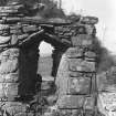
Under the eastern shoulder of Ben Eoligarry Mor, at the north end of the island, are the remains of a church and two detached chapels, grouped with the church to the west and the chapels lying eastward and to either side. Each building is oblong and is built of rubble, pinned up with shells and built in lime mortar .The church, which was dedicated to St Barr, measures 38 feet by 13 ¼ feet within walls averaging 2½ feet thick. The gables are reduced almost to ground level, but the side walls stand to a height of 7 or 8 feet; the western part of the south wall seems to have been rebuilt.
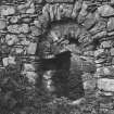
The entrance (Fig. 178) lies to the north, and is built with slightly tapering jambs, being 2¼ feet wide at the bottom and 1¾ feet at the head, which is a false arch formed by two inclined lintels within a relieving arch ; internally the jambs are in two orders beneath a second arch. The door appears to have been only 2 feet 11 inches in height from ground level to the springing of the false arch, and may be compared with the entrance of the southern chapel at Howmore, which is 3 feet 2 inches in height. Three windows remain, one to the north (Fig.179), two to the south, the most easterly being to light the altar. These windows are 11 inches wide and have rounded heads externally, while internally the head is a false arch; the breasts are stepped. The seating for the altar, about 5 feet long and 3 feet broad, remains against the east gable. Within the ruin and beside the entrance lies a stone 14 by 8 inches, having a circular basin 7 inches deep and 10 inches in diameter hewn in it.
The northern chapel, which is now subdivided for burials by a partition, measures 26 by 9¾ feet within walls 1 foot 10 inches thick. The gables, which are tabled, are entire; the side walls stand 4 ¾ feet above the present ground level. The entrance, 2 feet 8 inches wide, faces west. There are three windows in each side wall and one centred in the east gable, all 3 1/8 inches wide. This appears to be the latest building of the group.
The third chapel, the most southerly structure, measures 14½ by 8 ½ feet within walls 1 ¾ feet thick, the west gable alone being 2 feet 1 inch thick ; the latter wall remains for a height of 7 ¼ feet, the other walls are, generally, reduced to a height of less than 2 feet above the present ground level, and the only feature left is a small window to the north with splayed jambs and arched head, lintelled internally ; farther west in the same wall are traces of another.
GRAVE SLABS. (a) In St Mary's Church is a finely cut, well preserved grave slab measuring 6 feet 5 inches in length along the dexter side, 6 feet 3½ inches on the opposite side, 18½ inches in breadth at the top and 14½ inches at the bottom. Round the edge is a double bead moulding, and in the panel so formed is a claymore with slightly curved quillons and a round pommel spiked on the top, surrounded by an interlaced foliaceous design based on the three-lobed leaf. At the top is a complicated piece of knot-work developed out of the stalks of the foliage. (Fig. 146.)
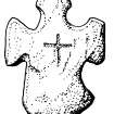
(b) A slab of slate in a good state of preservation lies in the eastern half of St Barr's Church. It is 6 feet 3 ½ inches long, 21 inches broad at the top, tapering to 18 inches some 6 inches from the bottom, where the corners are cut off, making the stone 14 inches in width at the foot. There is a flat moulding with a bead inside round the edge. The ornamentation consists of a blunt pointed claymore with depressed quillons terminating in lozenges and a round pommel with a blunt spike on the top. On either side of and below the sword is an interlaced foliaceous design. The upper part of the slab bears a panel filled in with an interlaced foliaceous cross of eight rays springing from an interlaced centre. (Fjg. 147.)If this slab is not attended to shortly the ornamentation will scale off, as the roots ofweeds are working their way into the stone.(c) A third slab on a grave in the churchyard measures 6 feet 1 inch in length, 18 ½ inches wide at the top and 17 inches at the foot. Part of the ornamentation has weathered off. This consists of an interlaced foliaceous design with a lymphad or galley near the top and a deer with a smaller animal behind it at the foot. (Fig. 148.)
(d) There is another slab, but as it is of sandstone it is badly weathered and is fast deteriorating further. Round the edge is an inscription in Latin letters. The base of a stepped cross and part of the shaft can be distinguished in the centre, with a rude skull carved on either side of the cross near the top. On the sinister side of the shaft is a row of rosettes, and the handle of a sword is clearly seen between these and the inscription.
Between 1915 and 1924 the slabs Nos. 2 and 4 have disappeared from view, whether removed or entirely overgrown. There are local tales of stones having been taken away from here without any authority.
HISTORICAL NOTE. Dean Monro specifies "ane paroche kirke, namit Killbare." Martin mentions the church and a chapel beside it. His account runs thus: "The church in this island is called Kilbarr, i.e. St Barr's Church. There is a little chapel by it, in which Macneil and those descended of his family are usually interred. The natives have St Barr's wooden image standing on the altar, covered with linen in form of a shirt; all their greatest asseverations are by this saint. I came very early in the morning with an intention to see this image, but was disappointed; for the natives prevented me by carrying it away, lest I might take occasion to ridicule their superstition, as some Protestants had done formerly; and when I was gone it was again exposed on the altar. They have several traditions concerning this great saint. There is a chapel (about half a mile on the south side of the hill near St Barr's Church) where I had occasion to get an account of a tradition concerning this saint, which was thus: 'The inhabitants having begun to build the church, which they dedicated to him, they laid this wooden image within it, but it was invisibly transported (as they say) to the place where the church now stands, and found there every morning.' This miraculous conveyance is the reason they give for desisting to work where they first began. . . . All the inhabitants observe the anniversary of St Barr, being the 27th of September; it is performed riding on horseback, and the solemnity is concluded by three turns round St Barr's Church. This brings into my mind a story which was told me concerning a foreign priest and the entertainment he met with after his arrival there some years ago, as follows:-This priest happened to land here upon the very day, and at the particular hour of this solemnity, which was the more acceptable to the inhabitants, who then desired him to preach a commemoration sermon to the honour of their patron St Barr, according to the ancient custom of the place. At this the priest was surprised, he never having heard of St Barr before that day; and therefore knowing nothing of his virtues, could say nothing concerning him; but told them that if a sermon to the honour of St Paul or St Peter could please them, they might have it instantly. This answer of his was so disagreeable to them that they plainly told him he could be no true priest, if he had not heard of St Barr, for the Pope himself had heard of him; but this would not persuade the priest, so that they parted much dissatisfied with one another. They have likewise a general cavalcade on St Michael's Day, in Kilbar village, and do then also take a turn round their church Every family, as soon as the solemnity is ended, is accustomed to bake St Michael's cake, as above described; and all strangers, together with those of the family, must eat the bread that night" (1). The Statistical Account (1794) says: "In Kilbar are two churches, built by the monks, belonging to Icolumkill; another at Borve, dedicated to St Michael” (2).
RCAHMS 1928, visited 8 August 1924.
OS map: Barra lxiii.
(1) A Description of the Western Islands of Scotland, by Martin, pp. 92 and 99
(2) vol. xiii., p. 335.
External Reference (25 June 1948)
EXTERNAL REFERENCE:
National Library
"Country Life" - June 25th, 1948, p. 1276 - photograph & article.
Field Visit (24 May 1965)
There are the extant remains of three buildings in the burial ground of Cille-Bharra, which is now enclosed and still in use. No trace of a fourth (B) could be found.
St Barr's Church (A - NF 0551 0738) measures 11.6m by 4.0m, within walls 0.7m thick, and survives to a maximum height of 2.2m. Chapel 'C' (NF 0553 0738) measures 8.0m by 3.0m within walls 0.6m thick, and survives to roof height, 2.6m, in the E and W gables. Chapel 'D' (NF 0552 0737) measures 4.4m by 2.0m internally, within walls 0.6m thick, and survives to a height of 2.3m in the W gable.
All these buildings are bonded with shell and lime mortar. No name is known locally for any of the chapels, nor could the find-spot of the Runic stone be located.
According to MacKenzie (C Mackenzie 1936) there was a ruined priory at Cille Bharra c.1697.
Visited by OS (N K B) 24 May 1965.
Publication Account (1985)
On the eastern slope of Ben Eoligany are the remains of a medieval church dedicated to St Barr (Cille Bharra) and two chapels, a group similar to that at Howmore, South Uist (NF 758364). Only parts of the side walls of the church still stand; the doorway is on the north side and three windows survive, two at the east end providing light for the altar. On the inside the windows have a pointed arch formed by two lintels set diagonally, while on the outside there is a round-headed arch.
One chapel is largely ruinous, and the west gable stands only to a height of about 2m. The other is well preserved and has recently been re-roofed to provide a shelter for several carved slabs which were in the cemetery. This chapel, or perhaps burial-aisle, is probably later in date than the two other buildings; the entrance was in the west gable, but there is a secondary entrance in the south wall, and there are narrow slit windows in the side walls and east gable.
There are several slabs of interest, including the only West Highland graveslabs on Barra: two of these are decorated with a claymore and foliaceous designs; another is badly weathered, but a galley and a deer can still be seen. An unusual stone found in 1865 is now in NMAS; on the front there is an interlace-filled cross with side panels of scrolls and key pattern. The back has a runic inscription, which reads 'after Thorgerth,Steinars daughter, this cross was raised' and dates to the 10th or early 11 th century.
Information from ‘Exploring Scotland’s Heritage: Argyll and the Western Isles’, (1985).
External Reference (16 February 2001)
Scheduled as Cille Bharra, church, two chapels and seven grave markers.
Information from Historic Scotland, scheduling document dated 16 February 2001.
Reference (2001)
The medieval parish church was at Cille Bharra in the N peninsula, on the NE slope of Ben Eoligarry and 600m from the E coast. The dedication was to St Barr, traditionally identified with St Finbarr of Cork but described in the Aberdeen Breviary as born in Caithness.(i) The burial-ground, which in 1878 was represented as an unenclosed oval area,(ii) contains a ruined church of late medieval date, and two smaller chapels which were probably burial-aisles of post-medieval origin.(iii) The larger of these, to the NE of the church, was re-roofed about 1980 to house three late medieval graveslabs of the Iona school and an inscribed slab of about 1600.(iv) The burial-ground contains three cross-marked stones, and a cross-slab inscribed in Norse runes, found there in 1865, was acquired by the National Museum of Antiquities of Scotland in 1880.(v)
(1) Earthfast gravemarker of gneiss, 0.43m in visible height by 0.31m and 0.16m thick. The surface is now whitewashed, with dark paint in the grooves. On one face there is a sunken Latin cross, 0.26m high by 0.15m in span, executed with a deep U-section groove. The base is triangular and the other terminals appear to be barred.
(2) Cruciform stone of diorite, broken at the foot. It measures 0.55m in height by 0.43m in span and 75mm thick. The shaft tapers from 0.27m to 0.22m below the tightly rounded lower armpits. The upper armpits are more semicircular in outline, and the top arm and right side-arm are tapered whereas the left arm is wedge-shaped. At the centre there is incised a Latin cross, 0.15m high and 0.12m across the arms which curve slightly upwards.
(3) Cruciform stone of diorite, 0.66m by 0.29m across the arms and 85mm in maximum thickness. It is a cruder version of no.2, with a shaft which tapers from 0.3m to 0.15m, a straight-sided top arm 0.13m wide, and short wedge-shaped side-arms. The lines of the tightly rounded armpits are continued as shallow grooves on the surface, in one case for 70mm. On one face (a) there is an incised central cross, 0.17m high and 0.19m across the arms, which are set at mid-height. The corresponding cross on face (b) measures 0.16m by 0.15m.
(4) (NMS X.IB 102). Cross-slab of dark grey local garnet metapelite, broken obliquely at the head and flaked at the foot of face (a). It measures 1.36m in height and increases in width from 0.25m at the foot to a maximum of 0.39m below the head; the thickness varies from 45mm to 80mm. Face (a) is filled by a cross in low relief, incomplete at head and foot but over 0.85m in height and 0.38m across the arms. It is defined by a bead-moulding which encloses sunken circular armpits about 30mm in diameter, and the shaft tapers slightly downwards whereas the arms are straight-sided. The cross is filled with flat interlace, comprising a four-strand plait in the shaft and less regular interlace in the cross-head and arms. The sides of the shaft are flanked by continuous square key-pattern, linked to the uncarved area at the foot of the shaft, and then by simple S-scrolls below the cross-head. There are fragmentary remains of similar scrolls flanking the top arm.
Face (b) is filled with an inscription in Old Norse runes, incised in three lines which read down from the top of the slab. The letters in the first line are about 0.16m high, while those in the second line, which is enclosed by two irregular incised lines, vary from 65mm to 100mm. Only a few characters remain at the beginning of the third line, which is heavily worn. Although the surface on which the runes are cut appears to have been lightly dressed, many of them are damaged and the readings by Stephens and Olsen involve many doubtful assumptions. A reading has been made by Professor R I Page.(vi)
]*ir thur(:)kirthu:s(t)i*ar
]*r(.)is(:)kurs(:)s**.ristr
]*(.)**
This probably contains the female name Thorgerth and, less certainly, the male name Steinar, with a commemorative formula referring to the erection of the cross.
Although comparisons have been made with Manx cross-slabs,(vii) the form of the ring-less cross is closer to those on slabs at Govan, and the S-scrolls flanking it may be matched in Argyll, at Soroby and Kilbride. The inscription filling one face of the slab can be compared with Scandinavian examples rather than Manx ones.(viii) A date in the second half of the tenth century is probable.
Footnotes:
(i) A Macquarrie 1984, 7-8, 29-30. A wooden figure of St Barr was preserved at Cille Bharra in the 17th century (M Martin 1934, 158).
(ii) OS 6-inch map, Inverness-shire (Hebrides), sheet 63 (1878/81).
(iii) RCAHMS 1928, No. 436; Macquarrie, op.cit., 23, 28, 33. T S Muir (1885) describes the demolition of a fourth building.
(iv) RCAHMS 1928, No. 436 (a-d) and figs.146-8. These slabs are of 14th-15th century date.
(v) G Stephens 1881, 33-4. The slab was identified by Alexander Carmichael, who recorded a tradition that it was brought from Iona (G Stephens 1884, 3 (1884), 315).
(vi) The Commissioners are indebted to Professors Page and M Barnes for access to material from their forthcoming Corpus of runic inscriptions (item no. SC8).
(vii) Liestol 1984, 228-9.
(viii) S B F Jansson 1987, pp.30, 33, 124.
G Stephens 1881, 33-6; J Anderson 1881, 227-9; NMAS 1892, 266; Allen and Anderson 1903, 3, 114-15; RCAHMS 1928, No.436 and figs.174, 177; Olsen, M, in H Shetelig, 6, 123-5, 174-7; J Close-Brooks and R B K Stevenson 1982, 43; Liestol 1984, 228-9; A Macquarrie 1984, 11-12, 17: H McGregor and J Cooper 1984, unpaginated; B E Crawford 1987, 175, 177.
I Fisher 2001, 106-8.
Standing Building Recording (2002)
NF 705 073 Desk-based assessment and building recording survey of St Barr's church and the South Chapel were undertaken in April 2002 in advance of a proposed conservation programme. Topographic survey of the graveyard was also undertaken. The site of a possible chancel screen was identified in St Barr's church; a previously unrecorded aumbry was identified in the S wall of South Chapel. The current condition of the buildings was recorded.
Archive to be deposited in the NMRS.
Sponsor: Benjamin Tindall Architects.
C Lowe 2002
Desk Based Assessment
NF70NW 3 7051 0738.
(NF 7051 0738) Cille-Bharra (NR)
OS 6" map, Inverness-shire, 2nd ed., (1904)
Cille-bharra: the remains of a church and two chapels, with walls up to 8ft high, in an unenclosed burial ground, are recorded by the RCAHMS (A, C and D), but MacCulloch (1824), refers to four buildings within an enclosure bearing traces of an external ditch. The building at A has been identified as St Barr's Church: a St Mary's Church is also noted but not identified. (RCAHMS 1928) Muir, who visited the site in 1886, thought the fourth chapel (B) (not mentioned by the RCAHMS) had been the parish church until about 1835. Martin, c.1700, refers to "St Barr's Church", with 'a little chappel by it ...'
A Runic stone found in the churchyard is now in the NMAS (IB 102) dated after AD 900.
Information from OS.
J MacCulloch 1824; T S Muir 1885; J R Allen and J Anderson 1903; RCAHMS 1928; A O Curle, M Olsen and H Shetelig 1954.

