
St Kilda, Dun, Na Sgarain


Wall (Post Medieval)
Site Name St Kilda, Dun, Na Sgarain
Classification Wall (Post Medieval)
Canmore ID 9657
Site Number NF19NW 11
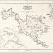
NGR NF 10883 97181
Datum OSGB36 - NGR
Permalink http://canmore.org.uk/site/9657


- Council Western Isles
- Parish Harris
- Former Region Western Isles Islands Area
- Former District Western Isles
- Former County Inverness-shire
NF19NW 11 1089 9717.
(NF 10899717) Castle (NR)
OS 6"map annotated by J Mathieson (1928)
Macaulay (K Macaulay 1764) describes a ruined fort here called 'Dun-Fir-Bholg', built of large, nearly square, quarried stones of a kind not seen above ground on the island. The standard of construction was superior to that of the St Kildan masons of that time.
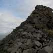
Sands (J Sands 1878) found no trace of a castle in 1876, and was of the opinion that there never had been one. Nor could he find any tradition of such a building. There is, however, a wall built of loose stones
c 400ft from the SE end of the island, broad at the base with parapets inside. Its use is problematical, whether for defensive purposes or for separation of sheep. It looked quite modern to Mathieson (J Mathieson 1764), and cuts off an area containing nothing except two small caves, with no signs of habitation.
K Macaulay 1764; J Sands 1878; J Mathieson 1928.
The site is a prominent spur of rock outcrop with a considerable quantity of loose rock scattered over it. Access to the site was not possible at time of visit, but the apparent wall described above, was examined through binoculars and at a distance from boat, and seems to agree with description. As the site does not appear to have possibly served as a defensive work (the cut-off area is to uneven) it can only be reasoned that the wall was built as a hefting-dyke, ie. to keep sheep away from the precipitous headland (as in three other cases on Hirta); but Mathieson's conclusions are generally agreed with. A closer examination is necessary to arrive at positive conclusion.
Visited by OS (J L D) 11 August 1967.
Note (1928)
Mr Sands refers to an ancient building “on the face of the hill called Sgal overlooking the bay…It had been covered with stones, but was found again last summer (1875). I went and threw out the rubbish. It is built with comparatively small stones…It contains two croopan” (i.e. wall beds). He also notes what Martin, in his Late Voyage to St Kilda (1698), called Tigh na Bana-ghaisgeach, ‘House of the Female Warrior’. “It is circular in form, about 9 feet in diameter, and built of flat stones, which converge as they ascend, until the space becomes so narrow that a single stone covers it. This house is covered outside with earth and turf…There were three croopan or beds in the wall”. One of these had already been destroyed, and subsequently a large quantity of stones were taken away. This place was a beehive shieling of the type described on [RCAHMS 1928] p. xli, as its local name, Airidh mhor ("big shieling"), indicated. A piece of wall on the island, called The Dun, is described by Mr Sands on pp. 189-90. Cf. also Proc. Soc. Ant. Scot., X., pp. 702-11. Dr Ross, architect, Inverness, from personal inspection, spoke of it in 1884 in these terms: “A rude wall across the promontory, near the extreme end, is pointed out as the remains of a fortification” (Trans. Inverness Scient. Socy. and Field Club, Vol. III., p. 80). There is an illustration of a bit of the wall in St Kilda, by Norman Heathcote (1900), p. 20. Mr Sands could discover no stone circle on the island of Boreray, as claimed by the Rev. K. Macaulay in his account (1764), “and the St Kildans seem never to have heard of it” (Ibid., XII., p. 189). On Tigh an Stallair on Boreray, of which nothing now remains, see Proc. Soc. Ant. Scot., VII., pp.173-4, and XII., p. 189.
Desk Based Assessment (3 February 1966)
(NF 10899717) Castle (NR)
OS 6"map annotated by J Mathieson (1928)
Macaulay (K Macaulay 1764) describes a ruined fort here called 'Dun-Fir-Bholg', built of large, nearly square, quarried stones of a kind not seen above ground on the island. The standard of construction was superior to that of the St Kildan masons of that time.
Sands (J Sands 1878) found no trace of a castle in 1876, and was of the opinion that there never had been one. Nor could he find any tradition of such a building. There is, however, a wall built of loose stones
c 400ft from the SE end of the island, broad at the base with parapets inside. Its use is problematical, whether for defensive purposes or for separation of sheep. It looked quite modern to Mathieson (J Mathieson 1764), and cuts off an area containing nothing except two small caves, with no signs of habitation.
Information from OS (BRS) 3 February 1966
K Macaulay 1764; J Sands 1878; J Mathieson 1928.
Field Visit (11 August 1967)
The site is a prominent spur of rock outcrop with a considerable quantity of loose rock scattered over it. Access to the site was not possible at time of visit, but the apparent wall described above, was examined through binoculars and at a distance from boat, and seems to agree with description. As the site does not appear to have possibly served as a defensive work (the cut-off area is to uneven) it can only be reasoned that the wall was built as a hefting-dyke, ie. to keep sheep away from the precipitous headland (as in three other cases on Hirta); but Mathieson's conclusions are generally agreed with. A closer examination is necessary to arrive at positive conclusion.
Visited by OS (J L D) 11 August 1967.
Photographic Record (1985)
Field Visit (2 September 2009)
Two stretches of rubble wall lie to either side of a rocky knoll cutting off the SE end of Dun (NF 10880 897175 to 10885 897185 and NF 10889 897196 to 10893 897203). The wall is aligned from NNE to SSW and is over 1m thick and up to 3m high.
(Dun 10)
Visited by RCAHMS (SPH) 2 September 2009

