
Burray, Bu Of Burray


Farmhouse (Period Unassigned), Farmstead (Period Unassigned), Midden (Period Unassigned)
Site Name Burray, Bu Of Burray
Classification Farmhouse (Period Unassigned), Farmstead (Period Unassigned), Midden (Period Unassigned)
Alternative Name(s) Bow Farmhouse And Steading
Canmore ID 9570
Site Number ND49NE 10
NGR ND 48514 97055
Datum OSGB36 - NGR
Permalink http://canmore.org.uk/site/9570


- Council Orkney Islands
- Parish South Ronaldsay
- Former Region Orkney Islands Area
- Former District Orkney
- Former County Orkney
ND49NE 10 48514 97055
The farm house of Bow takes the place of an older building, the remains of which, mainly the W wall of a range which may have been 16ft 6in wide, still survives at the S end for a length of 41ft. In this wall are three windows of a 17th century date and lying close at hand is a stone lintel bearing a monogram of the initials W.B.S. for William Stewart of Mains, brother of the first Earl of Galloway, and his wife Barbara. A fragment built into the wall of an outhouse bears the initials B.S. and high up on the inside of a gable of the steading is a cartouche displaying a coat of arms and below the date 1649. Other fragments of similar architecture are built into the walls of the steading.
RCAHMS 1946, visited 1930
As described by RCAHMS at ND 4850 9703. Of no particular importance.
Visited by OS (IMT) 14 May 1973.
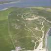
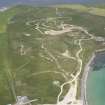
ND 485 970 An archaeological evaluation was conducted in January 2006 at the Bu of Burray as part of the conditions for a planning application for sand extraction. The evaluation comprised a desk-based assessment, walkover survey and an intrusive evaluation of 10% of the proposed extraction area. The work was required because the Bu of Burray and the dune links around it are potentially historically and archaeologically sensitive. The Bu of Burray is a B-listed farmhouse (ND49NE 10) built c 1800 on the site of a 17th-century mansion. The Bu of Burray was one of the principal bordland properties of the Earls of Orkney, indicating the potential for a high-status Norse site in the area. Past work has identified an area of prehistoric settlement (DES 1988, 29) with finds of great significance (PSAS 123, 319-36), and human remains were recovered on the N edge of the development area in October 2005 (DES 2005), associated with walls that appeared to be Norse or earlier in date.
The intrusive evaluation revealed a concentration of walls and deposits in the N part of the development area that are likely to have been associated with the remains found in 2005. It is proposed that this area will be avoided by the development. In the SE part of the site, a worn flagstone paving and part of a wall was revealed at the top of a dune. Down the side of the dune, midden-derived deposits were revealed that contained some vitreous slag, burnt bone and two sherds of grass-tempered pottery that are probably Norse in date. It is proposed that this area should also be avoided by the development.
In the middle of the area, the remains of a large walled peat stack was revealed, possibly the fuel store for the 17th-century mansion. The remains of a farm building were revealed in the NW part of the development site, associated with 18th- to 19th-century pottery and glass.
Copies of the report lodged with the Orkney SMR and NMRS.
Archive deposited in the Orkney SMR.
Sponsor: Mr. William Dass, Valhalla, Bu of Burray, Orkney.
Judith Robertson and Paul Sharman, 2006.
Archaeological Evaluation (January 2006)
ND 485 970 An archaeological evaluation was conducted in January 2006 at the Bu of Burray as part of the conditions for a planning application for sand extraction. The evaluation comprised a desk-based assessment, walkover survey and an intrusive evaluation of 10% of the proposed extraction area. The work was required because the Bu of Burray and the dune links around it are potentially historically and archaeologically sensitive. The Bu of Burray is a B-listed farmhouse (ND49NE 10) built c 1800 on the site of a 17th-century mansion. The Bu of Burray was one of the principal bordland properties of the Earls of Orkney, indicating the potential for a high-status Norse site in the area. Past work has identified an area of prehistoric settlement (DES 1988, 29) with finds of great significance (PSAS 123, 319-36), and human remains were recovered on the N edge of the development area in October 2005 (DES 2005), associated with walls that appeared to be Norse or earlier in date.
The intrusive evaluation revealed a concentration of walls and deposits in the N part of the development area that are likely to have been associated with the remains found in 2005. It is proposed that this area will be avoided by the development. In the SE part of the site, a worn flagstone paving and part of a wall was revealed at the top of a dune. Down the side of the dune, midden-derived deposits were revealed that contained some vitreous slag, burnt bone and two sherds of grass-tempered pottery that are probably Norse in date. It is proposed that this area should also be avoided by the development.
In the middle of the area, the remains of a large walled peat stack was revealed, possibly the fuel store for the 17th-century mansion. The remains of a farm building were revealed in the NW part of the development site, associated with 18th- to 19th-century pottery and glass.
Copies of the report lodged with the Orkney SMR and NMRS.
Archive deposited in the Orkney SMR.
Sponsor: Mr. William Dass, Valhalla, Bu of Burray, Orkney.
J Robertson and P Sharman 2006

