
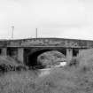
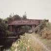
Union Canal, Bridge No. 56


Bridge (Period Unassigned), Canal (Period Unassigned), Railway Siding (19th Century) - (20th Century)
Site Name Union Canal, Bridge No. 56
Classification Bridge (Period Unassigned), Canal (Period Unassigned), Railway Siding (19th Century) - (20th Century)
Alternative Name(s) Reddingmuirhead Road Bridge
Canmore ID 95518
Site Number NS97NW 61.01
NGR NS 9154 7812
Datum OSGB36 - NGR
Permalink http://canmore.org.uk/site/95518


- Council Falkirk
- Parish Grangemouth
- Former Region Central
- Former District Falkirk
- Former County Stirlingshire
NS97NW 61.01 NS 9154 7812.
[This bridge carries Redingmuirhead Road over the Union Canal (built 1818-22, designer Hugh Baird), No.54, a typical bridge is described on NS97NW 61.02, q. v.]
(Undated) information in NMRS.
This bridge is shown on the 1st edition of the OS 6-inch map (Stirlingshire 1864, sheet XXX) carrying a track or minor road between a sawmill to the N and a coal pit to the S. On the 2nd edition of the OS 6-inch map (Stirlingshire 1899, sheet XXXne) the minor road runs between the sawmill and a smithy lying to the S of the canal. On the current edition of the OS 1:10000 map (1990) and on the OS Basic Scale digital map (2000) the road is marked as Station Road.
Information from RCAHMS (MD) 19 April 2001.

