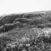
|
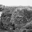
Photographs and Off-line Digital Images |
O 2479 |
Papers of Dr Raymond G Lamb, archaeologist, Keith, Moray, Scotland |
R. Lamb |
1972 |
Item Level |
|
|
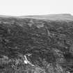
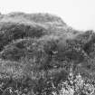
Photographs and Off-line Digital Images |
O 2480 |
Papers of Dr Raymond G Lamb, archaeologist, Keith, Moray, Scotland |
R. Lamb |
1972 |
Item Level |
|
|
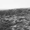
Photographs and Off-line Digital Images |
O 2481 |
Papers of Dr Raymond G Lamb, archaeologist, Keith, Moray, Scotland |
R. Lamb |
1972 |
Item Level |
|
|
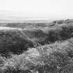
Photographs and Off-line Digital Images |
O 2482 |
Papers of Dr Raymond G Lamb, archaeologist, Keith, Moray, Scotland |
R. Lamb |
1972 |
Item Level |
|
|
Photographs and Off-line Digital Images |
O 2483 |
Papers of Dr Raymond G Lamb, archaeologist, Keith, Moray, Scotland |
R. Lamb |
1972 |
Item Level |
|
|
Photographs and Off-line Digital Images |
O 2484 |
Papers of Dr Raymond G Lamb, archaeologist, Keith, Moray, Scotland |
R. Lamb |
1972 |
Item Level |
|
|
Photographs and Off-line Digital Images |
O 2810 |
Papers of Dr Raymond G Lamb, archaeologist, Keith, Moray, Scotland |
R. Lamb |
1970 |
Item Level |
|
|
Photographs and Off-line Digital Images |
O 2808 |
Papers of Dr Raymond G Lamb, archaeologist, Keith, Moray, Scotland |
R. Lamb |
1970 |
Item Level |
|
|
Photographs and Off-line Digital Images |
O 289 |
Papers of Dr Raymond G Lamb, archaeologist, Keith, Moray, Scotland |
R. Lamb |
1970 |
Item Level |
|
|
Prints and Drawings |
ORD 198/1 |
Papers of Dr Raymond G Lamb, archaeologist, Keith, Moray, Scotland |
Plan BAR fig 18 ink Lamb |
1972 |
Item Level |
|
|
Manuscripts |
MS 1031/4 |
EASE Archaeology (Environment and Archaeology Services Edinburgh) |
Report on a Coastal Zone Assessment Survey of Orkney: Burray, Flotta, Graemsay, Hoy and South Ronaldsay. |
8/1997 |
Item Level |
|
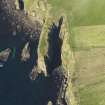 |
On-line Digital Images |
DP 060111 |
RCAHMS Aerial Photography Digital |
Oblique aerial view centred on the Brough of Windwick promontory fort, taken from the NE. |
13/5/2009 |
Item Level |
|
 |
On-line Digital Images |
SC 1923592 |
Papers of Dr Raymond G Lamb, archaeologist, Keith, Moray, Scotland |
R. Lamb |
1972 |
Item Level |
|
 |
On-line Digital Images |
SC 1923593 |
Papers of Dr Raymond G Lamb, archaeologist, Keith, Moray, Scotland |
R. Lamb |
1972 |
Item Level |
|
 |
On-line Digital Images |
SC 1923594 |
Papers of Dr Raymond G Lamb, archaeologist, Keith, Moray, Scotland |
R. Lamb |
1972 |
Item Level |
|
 |
On-line Digital Images |
SC 1923595 |
Papers of Dr Raymond G Lamb, archaeologist, Keith, Moray, Scotland |
R. Lamb |
1972 |
Item Level |
|
 |
On-line Digital Images |
SC 1923596 |
Papers of Dr Raymond G Lamb, archaeologist, Keith, Moray, Scotland |
R. Lamb |
1972 |
Item Level |
|
 |
On-line Digital Images |
SC 1923597 |
Papers of Dr Raymond G Lamb, archaeologist, Keith, Moray, Scotland |
R. Lamb |
1972 |
Item Level |
|
 |
On-line Digital Images |
SC 1923636 |
Papers of Dr Raymond G Lamb, archaeologist, Keith, Moray, Scotland |
R. Lamb |
1970 |
Item Level |
|
 |
On-line Digital Images |
SC 1923637 |
Papers of Dr Raymond G Lamb, archaeologist, Keith, Moray, Scotland |
R. Lamb |
1970 |
Item Level |
|
|
Photographs and Off-line Digital Images |
O 2809 |
Papers of Dr Raymond G Lamb, archaeologist, Keith, Moray, Scotland |
R. Lamb |
1970 |
Item Level |
|
 |
On-line Digital Images |
SC 2007867 |
Papers of Dr Raymond G Lamb, archaeologist, Keith, Moray, Scotland |
R. Lamb |
1970 |
Item Level |
|
 |
On-line Digital Images |
SC 2355334 |
Records of the Ordnance Survey, Southampton, Hampshire, England |
South Ronaldsay, Brough Of Windwick, ND48NE 11, Ordnance Survey index card, page number 1, Recto |
1958 |
Item Level |
|
 |
On-line Digital Images |
SC 2355335 |
Records of the Ordnance Survey, Southampton, Hampshire, England |
South Ronaldsay, Brough Of Windwick, ND48NE 11, Ordnance Survey index card, page number 2, Verso |
1958 |
Item Level |
|


