
South Ronaldsay, Brough Of Windwick


Promontory Fort (Period Unassigned)
Site Name South Ronaldsay, Brough Of Windwick
Classification Promontory Fort (Period Unassigned)
Canmore ID 9518
Site Number ND48NE 11
NGR ND 4586 8724
Datum OSGB36 - NGR
Permalink http://canmore.org.uk/site/9518


- Council Orkney Islands
- Parish South Ronaldsay
- Former Region Orkney Islands Area
- Former District Orkney
- Former County Orkney
ND48NE 11 4586 8724
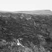
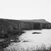
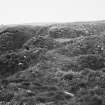
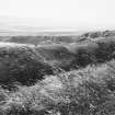
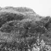
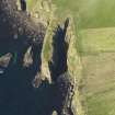
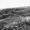
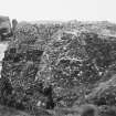
ND 4586 8724. 'The Brough' (OS 6" map, 1902) promontory, running NE-SW, has been enclosed on the landward side by a bank and ditch isolating an area c.60.0m x 14.0m. Erosion on the S shows that the bank (6.0m wide x 0.5m high) is composed of earth on a foundation of horizontally laid slabs. The ditch is 3.5m deep and its inner face has been revetted with dry stone walling.
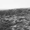
Outside the bank and ditch are three hollows which are probably modern. Along the SE edge of the internal area are traces of dry-stone walling, which may be the remains of an enclosure wall around the promontory edge. Possibly a fort.
Surveyed at 1:2500 scale.
Visited by OS (IMT) 2 May 1973
Promontory fort.
R G Lamb 1980
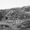
Lamb describes this promontory fort as having 2 banks crossing the isthmus at the inner end with a series of banks and ditches outside. OS (IMT) describes 1 bank with a ditch some 10m distant.
Another interpretation is thus: an inner bank without ditch or apparent entrance. A second low bank 10m from it with a ditch immediately in front but considerably eroded on either side of a narrow rocky spine utilised as the approach. The N scarp of this ditch exposes drystone walling (OS (IMT)) and may have a counterscarp bank on its S side. The following 3 hollows (ditches with intervening banks according to Lamb) appear to be the result of erosion and landslip rather than forming part of the original defences, as there are no traces of ditches corresponding on the N side of the spine as would be expected (plan amended).
Visited by OS (JLD) 15 May 1981
ND 458 872 The Brough: promontory fort, prehistoric.
Sponsors: Historic Scotland, Orkney Archaeological Trust.
G Wilson and H Moore 1997.
Desk Based Assessment (August 1997)
This site was not inspected due to its dangerous location, surrounded on all sides by high vertical cliffs. Previous investigations record that the promontory (aligned NE-SW) is enclosed on the landward side by a bank and ditch; the area enclosed measures 60m by 14m. The bank is 6m wide and 0.5m high. In a coastal exposure, the bank was seen to be constructed from soil built over horizontally-coursed slabs. The ditch, 3.5m deep, has a revetted drystone wall against its inner face. Fragments of drystone walling to the SE were thought to be the remains of an enclosure wall around the edge of the promontory.
Moore and Wilson, 1997
Coastal Zone Assessment Survey
Note (13 February 2015 - 31 May 2016)
What are probably the remains of a fort are situated on a precipitous promontory below Stella Maris on the E coast of South Ronaldsay, though the composition of its defences is unclear. The OS surveyor who noted the fort in 1973 identified a single rampart and ditch, and suggested that three hollows in the S margin of the promontory outside this line were probably modern. The latter, however, are identified by Raymond Lamb as the butt ends of no less than four ditches with intermediate ramparts on the S side of a central entrance causeway, together with another two on the N side. The interior, which measures some 60m in length from ENE to WSW by 14m transversely, is featureless, though there are traces of drystone masonry along its SE margin.
Information from An Atlas of Hillforts of Great Britain and Ireland – 31 May 2016. Atlas of Hillforts SC2814
Orkney Smr Note
A narrow headland projecting from the cliffs. The defensive system is two banks crossing the isthmus at the inner end with a series of banks and ditches outside. Entrance path is central; on S side of it the outer system comprises 4 scooped out ditches with 3 intervening banks, on N side 2 ditches with 1 rampart between. The ramparts are partly built of turf and stand up to 2.5m above ditch bottoms. Site overgrown and no structures are visible within the fort. Lamb 1980 p50 and 77
Information from Orkney SMR [n.d.]

