
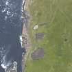
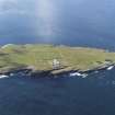
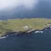
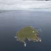
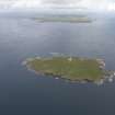
Muckle Skerry


Chambered Cairn(S) (Neolithic)
Site Name Muckle Skerry
Classification Chambered Cairn(S) (Neolithic)
Alternative Name(s) Pentland Skerries; Pentland Firth
Canmore ID 9512
Site Number ND47NE 8
NGR ND 4615 7835
NGR Description ND 4615 7835 and ND 4617 7837
Datum OSGB36 - NGR
Permalink http://canmore.org.uk/site/9512


- Council Orkney Islands
- Parish South Ronaldsay
- Former Region Orkney Islands Area
- Former District Orkney
- Former County Orkney
ND47NE 8 4615 7835 and 4617 7837.
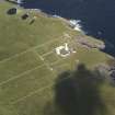
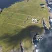
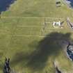
Stone foundations and traces of kitchen midden immediately N of the central pool to the W of the lighthouse on Muckle Skerry (information from A Black, lighthouse keeper).
RCAHMS 1946
Black is undoubtedly referring to two adjacent structures ('A' and 'B'), at ND 4615 7835 and ND 4617 7837 respectively.
'A', possible an Orkney-Cromarty stalled cairn, consists of a peat-covered stony mound about 15.0m NE-SW by 10.5m NW-SE and 0.8m high with several thin slabs on edge protruding through the top, the highest 0.7m.
'B', five metres to the NE and similar to 'A' but considerably eroded. There are so many fallen slabs within this cairn that it is difficult to tell which of the protruding stones are in situ.
No midden material visible in either cairn.
Surveyed at 1/10,000.
Visited by OS (ISS) 8 May 1973
Orkney-Cromarty stalled type chambered cairn.
J L Davidson and A Henshall 1989

