
Burraland


Broch (Iron Age), Promontory Fort (Prehistoric)(Possible), Settlement (Iron Age)(Possible)
Site Name Burraland
Classification Broch (Iron Age), Promontory Fort (Prehistoric)(Possible), Settlement (Iron Age)(Possible)
Canmore ID 948
Site Number HU42SW 1
NGR HU 44687 23199
Datum OSGB36 - NGR
Permalink http://canmore.org.uk/site/948


- Council Shetland Islands
- Parish Dunrossness
- Former Region Shetland Islands Area
- Former District Shetland
- Former County Shetland
HU42SW 1 4468 2319
(HU 4468 2319) Brough of Burraland (OE)
OS 6" map, Shetland, 2nd ed., (1903).
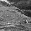
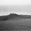
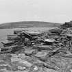
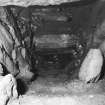
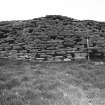
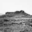
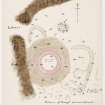
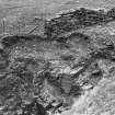
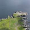
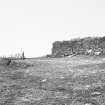
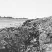
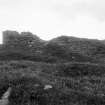
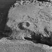
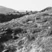
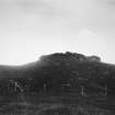
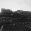
A broch, which, although delapidated, still stands to a maximum height of 12', and occupies a position of great natural strength.
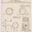
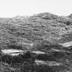
Within the wall there is clear evidence of a gallery extending almost completely round the circumference at about 10' above ground level. At this height the overall diameter is at least 55' and the wall thickness up to 10'.
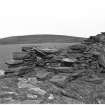
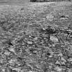
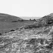
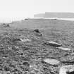
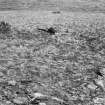
Outbuildings are grouped round the broch, particularly on the south, but these are now so ruinous that their general lay-out is very largely obscured.
RCAHMS 1946, visited 1930.
Generally as described by RCAHMS. The entrance, though not obvious, is in the SW quadrant. An unusual broch in the ratio of wall thickness to internal diameter.
Surveyed at 1/2500.
Visited by OS (RL), 13 May 1968.
Field Visit (3 September 1930)
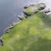
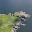
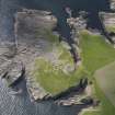
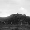
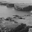
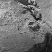
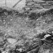
Broch of Burraland. On the W. shore of the Sound of Mousa, at the foot of the Ward of Burraland and almost directly opposite to the Broch of Mousa, is another broch much broken down and dilapidated, though still standing to a height of about 12 ft. in places (Figs. 481, 482 and 483 [courtesy of J D Rattar]). It is situated in a position of great natural strength at the inner end of a high rocky promontory, which is appropriately named Hoga on account of its covering of rich grass (Jakobsen 1936, 50). Round it, and particularly on the S., are grouped a number of "outbuildings," but these are now so ruinous that their general lay-out is very largely obscured. There is little or no batter on the outer face of the broch wall except on the W. side, where it here and there shows as much as 10 in. in a height of roughly 9 ft. Within the wall there is clear evidence of a gallery extending almost completely round the circumference at about 10 ft. above ground-level. At this height the over-all diameter is at least 55 ft., and the wall-thickness up to 10 ft. No cells or openings are visible, and Hibbert, when he mentions ‘many chambers’ (1822, 255-6), is clearly referring to the passage just described.
RCAHMS 1946, visited 3 September 1930.
OS 6" map, Shetland, 2nd ed., (1903).
Measured Survey (1930)
The broch at Burraland was surveyed by RCAHMS c.1930. The plan was redrawn in ink and published at a reduced scale (RCAHMS 1946 Fig. 485).
Aerial Photography (October 1973)
Oblique aerial photographs of Burraland broch, Shetland, photographed by John Dewar in 1973.
Publication Account (2002)
HU42 1 BURRALAND
HU/447232 (visited 29/6/87)
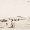
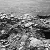
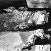
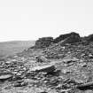
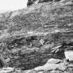
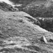
Broch on the inner end of a high rocky promontory in Dunrossness; it stands on the shore opposite Mousa and in a position of considerable natural strength (Ills. 4.58-62). Traces of many outbuildings are visible on the flat ground round about. The broch is badly dilapidated though the walls were reported as standing 12 ft. high in places [2]; the visible outer face rose to about 8 ft. in 1987. A mural gallery is visible most of the way round on the wallhead but there is no trace of a scarcement on the inside face (Ill. 4.65). The outer wall face seems to be nearly vertical instead of having the usual broch slope except on the west side where it slopes inwards 25cm (10 ins.) in 2.7m (9 ft.).
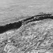
Structural analysis: a visit in 1987 revealed a number of features not hitherto commented on. The main entrance, completely lintelled over, is just visible above the surrounding rubble on the west side (Ill. 4.66), and the lintels appear to slope upwards towards the interior (Ill. 4.67). The outer parts of the sides of the passage have somehow converged and the outer end looks like an irregular hole; this doubtless explains why the entrance seems not to have been identified before.
The entrance gives a valuable clue as to the surviving height of the structure. There must be about 5 ft. of debris hiding the base of the wall here and the outermost lintel is some 2.0m below the wallhead above; this covers the lintels of the wallhead gallery here, which is therefore the first floor or Level 2 gallery.
Moreover it can be seen that the wallhead at about 12 o'clock opposite is considerably higher (Ill. 4.65), and here too the sides of a wallhead gallery can be seen. This therefore must be the second floor or Level 3 gallery, into which the voids at 11 o'clock and 2 o'clock must lead.
Thus Burraland is a well preserved structure, surrounded by a huge pile of debris, which has part of its Level 3 (second upper) gallery in position; it may well stand up to 14 ft. above the ground in places. The unusual thin-ness of the wall and the absence of the scarcement on the inner face are thus explain by the relatively great height of at which measurements have to be taken.
Dimensions: these are unreliable for the reason just explained; at the wallhead the diameter is 'at least' 55 ft. and the wall thickness at the same height is up to 10 ft.. It ground level the wall must be much more massive.
Sources: 1. OS card HU 42 SW 1: 2. RCAHMS 1946, vol. 3, no. 1143, 24 and figs. 485 (plan) and 481-3 (photographs): 3. Hibbert 1822, 255-6.
E W MacKie 2002
Note (3 March 2016 - 1 June 2016)
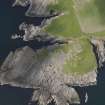
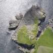
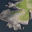
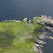
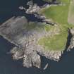
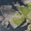
The W headland at the mouth of the S end of the Sound of Mousa is best known for its broch, standing opposite the rather better preserved tower on the island of Mousa, but the headland itself is defended by two walls cutting across the neck that connects it at the NW corner to the mainland. The outer of these, now no more than 0.5m high, is surmounted by a modern arrangement of drystone walls designed to control the access of stock onto the promontory and also forming a narrow pen, and is positioned where the precipitous geos to N and S are no more than 28m apart. Behind it a second wall reduced largely to a grass-grown bank cuts across the neck, and the coastal erosion survey carried out in 1998, suggests there may be yet another parallel bank behind this (see SCAPE Burraland: 6571). The area cut off on the headland is extensive, measuring 250m from in overall length from NNW to SSE by up to 110m in breadth (2ha), but over half of this is now bare storm-washed rock dipping down southwards to the sea. Nevertheless, an area of at least 0.9ha has formerly been grass-grown, though the storm beach is actively advancing into this area from the SSE and the occupiable area may well have been in excess of 1ha. The broch, with its galleried walls still over 2.5m in height and an entrance on the W, stands on the W side of this area, adjacent to the top of the southern geo separating the headland from the mainland. Around it, however, are extensive remains of a surrounding settlement, with evidence of numerous circular, oval and sub-rectangular stone structures detectable in the general spread of rubble beneath the turf. While these structures probably relate to contemporary or subsequent occupation around the broch, there is no particular reason to assume that either the broch or its surrounding settlement are associated with the defences across the neck.
Information from An Atlas of Hillforts of Great Britain and Ireland – 01 June 2016. Atlas of Hillforts SC4188

