|
Photographs and Off-line Digital Images |
C 80677 CS |
Records of the Royal Commission on the Ancient and Historical Monuments of Scotland (RCAHMS), Edinbu |
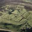
Haywood, miners' village and rows. The remains of the village visible only as footings. |
1/12/1994 |
Item Level |
|
|
Photographs and Off-line Digital Images |
B 99661 CS |
Records of the Royal Commission on the Ancient and Historical Monuments of Scotland (RCAHMS), Edinbu |
Haywood, the footings of the miners village |
1/4/1993 |
Item Level |
|
|
Photographs and Off-line Digital Images |
B 99660 CS |
Records of the Royal Commission on the Ancient and Historical Monuments of Scotland (RCAHMS), Edinbu |
Haywood Colliery, Pit No.10 and miners' rows |
1/5/1993 |
Item Level |
|
|
Photographs and Off-line Digital Images |
B 99795 CS |
Records of the Royal Commission on the Ancient and Historical Monuments of Scotland (RCAHMS), Edinbu |
Haywood, miners' village, footings of rows of cottages. |
1/4/1993 |
Item Level |
|
|
Photographs and Off-line Digital Images |
B 99796 CS |
Records of the Royal Commission on the Ancient and Historical Monuments of Scotland (RCAHMS), Edinbu |
Haywood, miners' village, footings of rows of cottages. |
1/9/1993 |
Item Level |
|
|
Photographs and Off-line Digital Images |
C 80734 CS |
Records of the Royal Commission on the Ancient and Historical Monuments of Scotland (RCAHMS), Edinbu |
Haywood miners' village, general view of the remains. |
20/8/1994 |
Item Level |
|
|
Photographs and Off-line Digital Images |
B 97389 CS |
RCAHMS Aerial Photography |
Oblique aerial view of the foundations of Haywood village. |
8/2/1995 |
Item Level |
|
 |
On-line Digital Images |
SC 354306 |
RCAHMS Aerial Photography |
Oblique aerial view of the foundations of Haywood village. |
8/2/1995 |
Item Level |
|
|
Photographs and Off-line Digital Images |
C 41144 |
RCAHMS Aerial Photography |
Haywood and Droveloan, oblique aerial view, taken from the W, showing Haywood village with the remains of miners' rows, and a war memorial, in the bottom right-hand corner of the photograph, a cottage and the two bings of a coal mine adjacent to the dismantled railway in the centre, and an area of rig at Droveloan cottage in the top half. |
2/2/1995 |
Item Level |
|
|
Photographs and Off-line Digital Images |
C 41145 |
RCAHMS Aerial Photography |
Haywood, oblique aerial view, taken from the SW, showing Haywood village with the remains of miners' rows and a farmstead in the bottom left-hand corner of the photograph, and a cottage and the two bings of a coal mine adjacent to the dismantled railway in the top right-hand corner. |
2/2/1995 |
Item Level |
|
|
Photographs and Off-line Digital Images |
C 41147 |
RCAHMS Aerial Photography |
Haywood, Droveloan and Greenbank, oblique aerial view, taken from the ESE, showing Haywood village with the remains of miners' rows and a farmstead in the centre of the photograph, a cottage and the two bings of a coal mine adjacent to the dismantled railway, and Droveloan cottage, in the bottom right-hand corner, and an area of rig at Greenbank in the centre right. |
2/2/1995 |
Item Level |
|
|
Photographs and Off-line Digital Images |
C 41148 |
RCAHMS Aerial Photography |
Haywood, Droveloan and Greenbank, oblique aerial view, taken from the E, showing Haywood village with the remains of miners' rows and a farmstead in the centre of the photograph, a cottage and the two bings of a coal mine adjacent to the dismantled railway in the bottom centre, and areas of rig beside Droveloan cottage in the bottom left-hand corner, and Greenbank in the top left-hand corner. |
2/2/1995 |
Item Level |
|
|
Photographs and Off-line Digital Images |
C 41149 |
RCAHMS Aerial Photography |
Haywood, Droveloan and Greenbank, oblique aerial view, taken from the NE, showing Haywood village with the remains of miners' rows and a farmstead, and adjacent rig at Greenbank, in the top centre of the photograph, a cottage and the two bings of a coal mine adjacent to the dismantled railway in the bottom centre, and an area of rig beside Droveloan cottage at the bottom left edge. |
2/2/1995 |
Item Level |
|
|
Photographs and Off-line Digital Images |
C 41150 |
RCAHMS Aerial Photography |
Haywood, Greenbank and Droveloan, oblique aerial view, taken from the NNE, showing Haywood village with the remains of miners' rows and a farmstead, with adjacent rig at Greenbank, in the top half of the photograph, a cottage and the two bings of a coal mine adjacent to the dismantled railway in the bottom centre, and an area of rig beside Droveloan cottage in the centre left. |
2/2/1995 |
Item Level |
|
|
Photographs and Off-line Digital Images |
C 41151 |
RCAHMS Aerial Photography |
Haywood, Droveloan and Greenbank, oblique aerial view, taken from the NNW, showing Haywood village with the remains of miners' rows and a farmstead in the centre of the photograph, the two bings of a coal mine adjacent to the dismantled railway at the left edge, and areas of rig at Droveloan cottage in the top half, and Greenbank in the right centre. |
2/2/1995 |
Item Level |
|
|
Photographs and Off-line Digital Images |
C 41152 |
RCAHMS Aerial Photography |
Haywood, Droveloan and Greenbank, oblique aerial view, taken from the NNW, showing Haywood village with the remains of miners' rows and a farmstead in the centre of the photograph, two bings of a coal mine adjacent to the dismantled railway in the left centre, and areas of rig at Droveloan cottage in the top half, and Greenbank in the right. |
2/2/1995 |
Item Level |
|
|
Photographs and Off-line Digital Images |
B 97385 CS |
RCAHMS Aerial Photography |
Haywood and Droveloan, oblique aerial view, taken from the NNW, showing Haywood village and the remains of miners' rows and a farmstead in the right centre of the photograph, two bings and an adjacent railway in the centre left, and and an area of rig at Droveloan cottage in the top left-hand corner. |
2/2/1995 |
Item Level |
|
|
Photographs and Off-line Digital Images |
B 97386 CS |
RCAHMS Aerial Photography |
Haywood and Droveloan, oblique aerial view, taken from the W, showing Haywood village and the remains of miners' rows and a farmstead in the bottom right-hand corner of the photograph, two bings and an adjacent railway in the centre, and and an area of rig at Droveloan cottage rig in the top right-hand corner. |
2/2/1995 |
Item Level |
|
|
Photographs and Off-line Digital Images |
B 97387 CS |
RCAHMS Aerial Photography |
Haywood, oblique aerial view, taken from the WNW, showing Haywood village and the remains of miners' rows and a farmstead in the right centre of the photograph. |
2/2/1995 |
Item Level |
|
|
Photographs and Off-line Digital Images |
B 97388 CS |
RCAHMS Aerial Photography |
Haywood village and Greenbank, oblique aerial view, taken from the NE, showing the remains of the village and farmstead in the centre of the photograph, and an area of rig at Greenbank in the top left-hand corner. |
8/2/1995 |
Item Level |
|
|
Photographs and Off-line Digital Images |
B 97390 CS |
RCAHMS Aerial Photography |
Haywood village and Greenbank, oblique aerial view, taken from the NNE, showing the remains of the village and farmstead in the centre of the photograph. |
8/2/1995 |
Item Level |
|
|
Photographs and Off-line Digital Images |
B 97391 CS |
RCAHMS Aerial Photography |
Haywood and Greenbank, oblique aerial view, taken from the SSW, showing the remains of the village and farmstead in the centre of the photograph, Haywood Colliery Pit No. 10 in the top- right-hand corner, and an area of rig at Greenbank in the bottom half. |
8/2/1995 |
Item Level |
|
|
Photographs and Off-line Digital Images |
B 97392 CS |
RCAHMS Aerial Photography |
Haywood village and Greenbank, oblique aerial view, taken from the SSW, showing the remains of the village and farmstead in the centre of the photograph, and an area of rig at Greenbank in the bottom half. |
8/2/1995 |
Item Level |
|
|
Photographs and Off-line Digital Images |
B 97393 CS |
RCAHMS Aerial Photography |
Haywood village and Greenbank, oblique aerial view, taken from the SSW, showing the remains of the village and farmstead in the centre of the photograph, and an area of rig at Greenbank in the bottom half. |
8/2/1995 |
Item Level |
|


