
Burn Of Redstane


Enclosure (Period Unassigned), Settlement (Period Unassigned)
Site Name Burn Of Redstane
Classification Enclosure (Period Unassigned), Settlement (Period Unassigned)
Alternative Name(s) Cunningsburgh; Thief's Hole
Canmore ID 937
Site Number HU42NW 4
NGR HU 4245 2723
Datum OSGB36 - NGR
Permalink http://canmore.org.uk/site/937


- Council Shetland Islands
- Parish Dunrossness
- Former Region Shetland Islands Area
- Former District Shetland
- Former County Shetland
HU42NW 4 4245 2723.
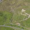
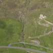
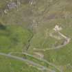
HU 424 275. A Neolithic house lies on a level plateau near the Thief's Hole on the 400' contour and a short distance west of another house (HU42NW 3). It is oval in shape the outside being traceable on the north and south sides as the scarp of a stony bank with large peripheral stones here and there. The structure measures overall 47' from NE to SW and 34' transversely. The ruin has been robbed of its stones for the building of a late oblong enclosure on a parallel axis inside the house. This erection measures 22' by 17 1/2' over walls 3 1/4' thick. The foundations of a boundary dyke at a distance of 73' on the NW and S, but widening elsewhere, enclose a field area around the site.
C S T Calder 1958.
HU 4244 2725. The remains of a house as described by Calder, within a probably contemporary irregularly-shaped enclosure. The oblong building or enclosure within the hut is much later.
Visited by OS (AA) 8 May 1968.
The house site was originally masked by a plantiecrub set in the middle of it. After its removal the house was found to be a large oval 17.5m by 12m internally, with walls of turf and rubble construction where they survived, and a single paved entrance and passage. The house was divided internally by four radial pillars, which projected in from the walls. A branched and capped drain was found within the house as well as a series of central hearths and a stone lined and lidded fire box. C.200 stone tools and ard points were found, a few fragments of Bronze Age (possibly) pottery and c.0.3 of a steatite vessel with a rounded rim. The enclosure dyke and a 'D' shaped structure within it were also sampled for information about their construction and their date. Excavated in advance of a proposed new quarry.
B Smith, S Carter and V Turner 1988.
'Gone, destroyed or buried by quarrying.'
Information from OS field surveyor, August 1993.

