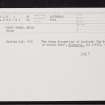
 |
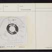
On-line Digital Images |
DP 298934 |
Papers of John Nicolson, antiquarian, Keiss, Caithness, Scotland |
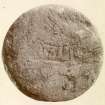
Photograph, Keiss Road Broch, inscribed sandstone disc. |
1894 |
Item Level |
|
 |
On-line Digital Images |
SC 1926335 |
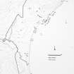
Caithness Coastal Survey |
General survey area plan. |
1982 |
Item Level |
|
 |
On-line Digital Images |
SC 1926339 |
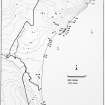
Caithness Coastal Survey |
Wick (North) Map |
1982 |
Item Level |
|
 |
On-line Digital Images |
SC 1926340 |
Caithness Coastal Survey |
Wick (North) Map |
1982 |
Item Level |
|
 |
On-line Digital Images |
SC 2245594 |
|
RCAHMS |
|
Item Level |
|
 |
On-line Digital Images |
SC 2354935 |
Records of the Ordnance Survey, Southampton, Hampshire, England |
Keiss, Kirk Tofts, 'Road' Broch, ND36SW 1, Ordnance Survey index card, page number 1, Recto |
1958 |
Item Level |
|
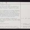 |
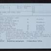
On-line Digital Images |
SC 2354936 |
Records of the Ordnance Survey, Southampton, Hampshire, England |
Keiss, Kirk Tofts, 'Road' Broch, ND36SW 1, Ordnance Survey index card, page number 2, Verso |
1958 |
Item Level |
|
 |
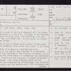
On-line Digital Images |
SC 2354937 |
Records of the Ordnance Survey, Southampton, Hampshire, England |
Keiss, Kirk Tofts, 'Road' Broch, ND36SW 1, Ordnance Survey index card, page number 3, Recto |
1958 |
Item Level |
|
 |
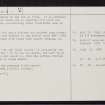
On-line Digital Images |
SC 2354938 |
Records of the Ordnance Survey, Southampton, Hampshire, England |
Keiss, Kirk Tofts, 'Road' Broch, ND36SW 1, Ordnance Survey index card, Recto |
1958 |
Item Level |
|
 |
On-line Digital Images |
SC 2354939 |
Records of the Ordnance Survey, Southampton, Hampshire, England |
Keiss, Kirk Tofts, 'Road' Broch, ND36SW 1, Ordnance Survey index card, Recto |
1958 |
Item Level |
|
 |
On-line Digital Images |
SC 2354940 |
Records of the Ordnance Survey, Southampton, Hampshire, England |
Keiss, Kirk Tofts, 'Road' Broch, ND36SW 1, Ordnance Survey index card, Recto |
1958 |
Item Level |
|


