
Nybster


Broch (Iron Age)(Possible), Roundhouse (Prehistoric)
Site Name Nybster
Classification Broch (Iron Age)(Possible), Roundhouse (Prehistoric)
Alternative Name(s) Mervyn Tower, Wic 091
Canmore ID 9329
Site Number ND36SE 56
NGR ND 3702 6314
Datum OSGB36 - NGR
Permalink http://canmore.org.uk/site/9329


- Council Highland
- Parish Wick
- Former Region Highland
- Former District Caithness
- Former County Caithness
(ND 3702 6314) Broch (NR)
OS 1:10,000 map, (1973)
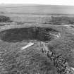
Nybster Broch was excavated by Sir Francis Tress Barry about 1900, revealing neither guard chamber nor mural cells. It has in internal diameter of 23ft and a wall thickness of 14ft. In 1910 the maximum height of the walls was 5ft 3ins.
The broch is defended by a possibly later forework and the whole is fronted by a ditch about 20ft wide which cuts off the promontory on which the broch stands. To seaward of the broch practically the whole promontory is covered by well-built out-buildings, oblong, circular, and irregular in plan.
Finds include a fragment of 2nd century Samian ware, as well as the more usual bone and stone objects.
A Young 1966; RCAHMS 1911, visited 1910.
Nybster Broch is as described and planned above.
Although there is no trace of a ditch cutting off the promontory, there are remains of secondary defensive banks and walls, probably contemporary with the broch forework. A modern monument to Sir Francis Tress Barry has been constructed immediately E of the broch, destroying several outbuildings. Two mounds at the seaward end of the promontory are probably excavation spoil heaps.
Resurveyed at 1:2500.
Visited by OS (R D) 14 September 1965
Classification of Roman material.
A S Robertson 1970.
A site of major signifcance in the study of the development of the broch in that it comprises the ground-galleried block-house of a pre-broch promontory fort, a solid-based broch, and a post-broch settlement. The block-house, which displays broch-like features, including a passage checked for two doors, is probably to be dated not much before the first century BC if not within it.
R G Lamb 1980.
Several sherds of 'broch' pottery were recovered from the upcast from illicit digging within the broch interior. Finds with investigator.
R B Gourlay 1981.
A promontory broch with a ditch. In good condition due to recent renovation.
C E Batey 1981.
Nybster Broch is generally as described and planned by the previous authorities. The excavations were not backfilled and most of the walling is exposted, albeit heavily overgrown. The previous field investigator noted 'secondary defensive banks and walls' immediately W of the forework. These have been completely levelled, but they were almost certainly fairly modern, perhaps spoil heaps, as the RCAHMS did not plan them, and they formed no logical pattern with the broch and its outer defences.
Revised at 1:2500.
Visited by OS (N K B) 22 July 1982.
ND 349 615; ND 370 631 As part of a wider study of Iron Age Caithness, the brochs and settlement complexes at Keiss Road, Wick (ND36SW 1), and Nybster, Wick (ND36SE 56) were surveyed in September 2004. The sites were previously investigated in the late 19th century by Sir Francis Tress Barry.
Sponsors: Highland Council, Caithness and Sutherland Enterprise, Caithness Archaeological Trust, AOC Archaeology Group, University of Nottingham, NMS.
J Barber, A Heald and J Henderson 2004
ND 3702 6314 As part of a wider study of Iron Age Caithness, four weeks of excavation of the broch and outbuilding complex at Nybster (ND36SE 56) took place in July 2005. The site was first excavated by Sir Francis Tress Barry in 1896. He uncovered a number of structural types including a 'broch', numerous cellular buildings and a sub-rectilinear building. Finds included 2nd-century Roman pottery.
Recent work on other sites excavated by Barry - particularly Tofts, Everley - has suggested that he may have left untouched archaeology on some of the Caithness sites and that re-investigation was a worthwhile exercise. With this in mind, trial excavations were undertaken at Nybster, following on from a survey season in 2004. Trenches were confined to the roundhouse wall and interior, two of the cellular outbuildings, and the rectilinear outbuilding.
Investigations of the roundhouse wall failed to uncover any inter-mural architectural features consistent with a broch. Inside the roundhouse a hearth, various internal partitions and tanks were uncovered, together with an associated floor layer. Numerous sherds of pottery, stone objects and bone tools were recovered.
Results from investigations of the two cellular outbuildings were mixed. The first outbuilding (which Barry had excavated fully) contained little meaningful surviving archaeology, although there were suggestions of earlier buildings within the complex. The second cellular building (which Barry only partly excavated) was more rewarding. Here, a floor layer with associated hearth and paving was uncovered, together with a notable pottery assemblage. Finds also include a range of bone objects (awls, etc.) and a bronze spiral finger ring.
Excavations of the rectilinear building suggested that the area was an amalgam of various structures, of which only a part was uncovered this year.
Sponsors: HS A, NMS, AOC Archaeology Group, University of Nottingham, Caithness Archaeological Trust.
J Barber, A Heald and J Henderson
Project (1980 - 1982)
Field Visit (1981)
A promontory broch with a ditch. In good condition due to recent renovation.
C E Batey 1981.
Publication Account (1995)
The broch here is only a low circular wall, but the interest lies in the associated structures found in the excavations by Sir Francis Tress Barry of Keiss Castle at the end of the last century. Unfortunately these structures have since decayed and are overgrown with long grass In summer. Nevertheless, some of the plan can be made out. The broch is built on a high rocky headland between two inlets, defended by a stout rampart faced with stone walls and a large curved ditch, only partly excavated. The entrance through the rampart has checks for two wooden doors, and there are the remains of stairs inside leading from ground level to the wall top. (Stone slabs bridging some of the holes on the site are modern, put there to assist visitors.) The entrance to the broch is round the far side. This was a solid-based broch, the entrance to the stair and any galleries being higher in the wall and now lost. There are a few partition slabs and a stone tank set in the broch floor.
All the rest of the headland is covered with the remains of buildings which seem mostly to be a contemporary settlement, in contrast to Forse Wag (no. 94) and Yarrows (no. 105) where the outbuildings are clearly later. These are now rather a jumble of ruins, with a large mound among them which is the excavator's spoil dump.
On the cliff near the broch is a strange monument known as Mervyn's Tower, built of rough stones and adorned with a number of grotesque heads. This was erected to Tress Barry by John Nicolson, the local farmer and sculptor who helped with his excavations. There are more sculptures in the garden of Nicolson's house, between the carpark and the museum. Back at the carpark is a picnic place, and a path down to the tiny harbour. More information about the broch and other local sites, with an excellent video 'Caves, Cairns and Castles', can be found in the Northlands Viking Centre in Auckengill.
Information from ‘Exploring Scotland’s Heritage: The Highlands’, (1995).
Publication Account (2007)
ND36 9 NYBSTER ('Brough Head') ND/3702 6314
Probable solid-based broch in Wick, Caithness, standing in a similar situation to Skirza Head (ND36 10, below) and Ness (ND36 8) – that is on a sheer-sided cliff promontory approachable only from one direction and which is defended by a massive curved outer wall. The site was excavated by Sir F Tress Barry in 1895-96 and the limited information gained was described by Anderson [2] who provides the only information about the work apart from a few photographs taken of the excavations. There are copies of all the Tress Barry photo-graphs in the Nicholson institute in Caithness and in the National Monuments Record of Scotland in Edinburgh. (visited in 1963, 1971 and 2005).
Nybster broch underwent further explorations in the summer of 2005 by a team from the National Museums of Scotland [16]. The discoveries made then will doubtless cause some of the ideas set out below to be modified.
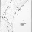
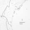
Description
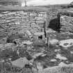
The promontory on which the site stands is about 45.8m (150ft) long and 41.2m (135ft) across at its widest part; it narrows to about 21.4m (70ft) at the seaward end. The main entrance faces just north of north-east, towards the sea, and is 4.27m (14ft) long; it is consistently 92cm (3ft) wide for the first 3.05m (10ft) at which point is set the door-frame. A pivot stone was found in position behind one of the door-checks. One check can be seen in a contemporary photograph and it gives the impression of being of built masonry rather than of a projecting slab. The pivot stone for the door was still in position in 1910, presumably behind the left check. No guard cell was found, and neither were any intra-mural features located during the original excavations; thus Nybster may be a simple ring of solid masonry and it stands nowhere higher than 1.53m (5ft).
However at about 10 o'clock there are signs of a possible raised doorway in the inner wallface, now built up; this was noticed both by the Commission [3] and by the author in 1963 but there are now no straight edges in the masonry and no firm conclusions can be drawn. On the general photograph which shows the interior after excavation this 'gap' should be at the left end of the circle but nothing seems to have been spotted at the time. Blocks may have been pulled out of the wall later.
It is quite possible that any intra-mural features which existed in this building were raised well above the floor, as at many other sites, so that no signs of these are preserved in the bottom 1.53m (5ft) of the inner face (Level 1). Nevertheless it is not impossible that Nybster was never more than a simple, massive-walled dun or roundhouse which was never very high; without evidence even of an intra-mural stairway its classification as a broch must remain tentative only. This site provides the well-known ambiguous answer to the question of whether the stump of a broch could ever have been a tall tower – "absence of evidence is not evidence of absence." It is striking that there is no second entrance here despite the fact that the broch doorway faces away from the outer defensive wall.
Two floor tanks or hearths were found on the north side of the central court and a drain ran out through the entrance passage. There are several radial slabs still visible set upright in the central court, which may be the remains of secondary structures; some of these continue the right side of the entrance into the interior. There is a small pit or well with a covering slab in the floor opposite the entrance.
According to Anderson the outer defences consist of a curved ditch and a massive wall just within this; the 'ditch' was said to be nearly 6.1m (20ft) wide and to run along “the segment of a circle” from one ravine to the other. No causeway is mentioned. However Swanson points out that there are no signs of a ditch apart from the trench dug by Tress Barry to expose the outer face of the outer wall [9], so Anderson may have mixed up his notes on Nybster with those on another site.
The wall is a massive curved barrier 3.05m (10ft) thick, increasing to about 4.58m (15ft) at the centre where the solitary entrance passage is situated. This wall is only about 1.89m (6ft) from the broch at its nearest point. The entrance is 4.5m long and 1.07m (3ft 6in) wide at the outer end; at 1.37m (4ft 6in) from the outside is the first door-frame built of slabs on edge set into the passage walls; after this the passage widens to 1.22m (4ft). A second door-frame is 3.66m (12ft) from the exterior and the plan suggests that there is an upright slab forming a sill stone at each door.
The thicker central part of this outer wall is relatively short (about 7.6m or 25 ft, including the passage) and at each end, on the inside face, is a short flight of steps, leading up towards the passage, which presumably gave access to the wallhead. The closeness of these flights of steps to the passage suggests that the outer wall was never very high; perhaps there was a parapet fronting the flat wall walk. The outer wall has evidently been modified more than once [9].
A number of round and nearly round chambers, connected by various walls, was found outside the broch on three sides. Again one tends to assume from the data from better excavated sites that these belong to a secondary phase of occupation (those abutting the broch on the seaward side surely do) but there is no way of being sure that this was the case at Nybster. The state of these 'outbuildings' in 1984 was recorded by Swanson [9].
Excavations in 2005
Re-excavation of the site began in 2005, by Andy Heald on behalf of the National Museums of Scotland [16]. Towards the end of July the work had already yielded some interesting results, including a bronze spiral finger-ring of classic middle Iron Age type from occu-pation deposits in one of the ‘outbuildings’ on the north-east side, confirming that the brochs in the north-east tip of Caithness belong to the Atlantic Iron Age tradition.
The broch itself is being re-examined, both in the central court and on the wallhead. An important discovery in 2005 was an occupation layer that extended under the wall, suggesting that the broch was built on an already inhabited site. This may support the idea that the promontory wall was the original defensive feature and that the broch was added later. Other internal features uncovered include a large rectangular enclosure of uncertain purpose – defined by large stone slabs on edge – and a water tank apparently sunk into the primary floor.
Trenches across the broch wall appear to confirm that it lacks any intra-mural features apart from the entrance. The core of packed sandstone slabs and rubble is preserved at the base, and looks suitable broch-like, but this is covered by shattered small rubble and soil; this gives the impression that the stump of the broch had been partly further destroyed and then evened off again with small rubble to provide the level, turfed wallhead seen in the photographs of the original excavation. It is curious that most of the the inner wallface stands higher than the surviving original wall core.
One interesting feature was found on the wallhead in the form of a small area of large, carefully laid flat slabs at about 9 o’clock. These are about 1.5m above the interior floor and may be the only direct evidence for Nybster having once been a hollow-walled tower. The slabs look like the neat floor of a raised doorway into the wall (the sides of which have completely vanished), which perhaps once led out on to the scarcement and on to the raised wooden floor which rested on it. The evidence is striking but is perhaps not yet quite positive enough to classify the site as a ‘broch’ rather than as a ‘probable broch’.
Early finds [2, 142: 7]
Bone objects included 7 awls or borers from 95-172mm in length, 3 long-handled combs, 2 of them decorated and 2 (including the plain one) with a fishtail handle, a flat almost rectangular piece (with slightly convex sides) 95mm long, perforated with 3 holes and having a flat, disc-shaped protrusion on one face, a small strip 54mm long with rounded ends and a carefully bored hole at each end and 1 small bead 13mm in diam.
Stone implements included half of a small cup or lamp, a sandstone whorl, a rough sandstone disc with a depression in the middle of one face, a thin, well-shaped disc of slaty stone, 95mm in diam. and smoothed on both faces, a sandstone disc 95mm in diam. and with an incomplete perforation 19mm wide in the centre, 1 broken whetstone 54mm long, an oval sandstone vessel 292mm long, 191mm wide and 83mm deep and a sandstone vessel 215mm by 184mm and 92mm deep. In the NMS (GA 698) there is also a complete handled cup (the handle mostly broken off) 112-114mm in diam. and 48mm deep which seems not to be one of those mentioned above; it has an incised groove running round it just below the rim.
Pottery included 1 sherd of a Roman Samian decorated bowl of form Dr. 37 [6, Table II].
Objects of fired clay included 2 small cups or crucibles of reddish clay and a mould fragment with a tapering, square-sided hollow.
Animals bones and food refuse included the skull of an ox and antlers of red deer and a sample of carbonised oats.
Finds in 2005
A major discovery was a complete bronze spiral finger-ring in the occupation deposits of a chamber north-east of the broch.
Dimensions: (1) wall thickness 4.27m (14ft), internal diameter 7.02m (23ft) and overall diameter therefore 15.56m (51ft) [3]; (2) from the author's measurements – overall diameter 15.71m (51ft 6in), internal diameter (avg.) 6.25m (20ft 6in), therefore wall thickness c. 4.73m (15ft 6in). The average wall proportion is thus 60%. A careful survey of the central court in 1971 showed that it had been built close to an exact circle with a radius of 3.21 + 0.06 m, that is with a diameter of 6.42m (21.05ft).
Sources: 1. NMRS site no. ND 36 SE 4: 2. Anderson 1901, 139-42: 3. RCAHMS 1911b, 159-60, no. 518, and fig. 42: 4. Young 1962, 184: 5. Discovery and Excavation in Scotland 1981, 18: 6. Robertson 1970. 205: 7. Proc Soc Antiq Scot 43 (1908-09), 14-15 (finds): 8. Lamb 1980b, 20-1: 9. Swanson (ms) 1985, 571-76 and plan: 10. Batey (ms) 1981, no. 91: 11. R Gourlay in Discovery and Excavation Scotland 1981, 18: 12. Close-Brooks 1995, 148-9: 13. Hartley 1972, 54, no. 2: 14. Heald and Jackson 2001, 129-47: 15. A. Heald in Discovery and Excavation in Scotland, 2005
E W MacKie 2007
Excavation (2011)
ND 3702 6314 A community excavation was carried out at Nybster Broch, over two phases in summer 2011. The excavations focused on the enclosing rampart and the adjacent deposits, and latterly on the cellular roundhouses to the E end of the Nybster promontory.
It was discovered that the enclosing rampart had gone through at least two phases of construction and modification, with the original, slighter rampart heavily reinforced and enhanced by a second phase of building. During this second phase, the area around the entrance to the site was modified and a cell constructed within the thickness of the rampart wall. Finds within this cell included pottery, a saddle quern and a fragment of a pin mould. After the second phase, when the rampart had become ruinous, several stone cist-like structures were dug into the rubble. These features could not be confirmed as graves, although they resemble cist burials encountered by antiquarian excavations on other Caithness brochs. Finds from the fills included a stone pendant, a copper alloy strip and a crucible fragment.
Excavation to the E of the promontory investigated three cellular roundhouse structures. The largest of these contained at least four phases of hearth construction, associated with several superimposed occupation deposits and flagstone flooring. In several places, deposits undisturbed by Tress Barry’s excavations were encountered, and during the excavation of these a Roman melon bead was recovered. Other artefacts from these structures included ceramics, a complete bone pin and a bone knife handle.
Archive: RCAHMS (intended)
Funder: Heritage Lottery Fund, Highland Leader and Highland Council
AOC Archaeology Group, 2011
Note (16 February 2015 - 16 November 2016)
The broch at Nybster stands on a precipitous promontory which is also defended by a stout wall with a ditch about 6m in breadth drawn in a gentle arc across its landward side. The broch and the external buildings around its foot were explored in 1895-6 by Sir Francis Tress Barry and reported by Joseph Anderson (1901, 139-42, fig 20), and have since been re-excavated in 2005 (Barber, Heald and Henderson 2005) and 2011 (AOC Archaeology Group 2011). The broch measures 7m in diameter within a wall 4.3m in thickness and has an entrance on the NE. The excavations in 2011 showed that the outer wall was constructed in at least two phases, which saw an earlier wall of relatively slight build subsequently modified, particularly around the entrance in its central sector, where it was increased to 4.5m in thickness to incorporate a mural chamber and provided with flights of steps on either side; the entrance passage has door checks. After the wall had fallen into disrepair, several cist-like structures were inserted into the rubble, though neither produced evidence of a burial. The interior, which is occupied by the broch and a multi-period complex of smaller external buildings, measures about 50m from E to W by about 33m transversely (0.15ha). Finds from the earlier excavations include seven bone awls and three bone combs, several stone discs and vessels, a sherd of Samian of 2nd century AD date, two possible crucibles and a mould fragment (Anderson 1901, 142; Proc Soc Antiq Scot 43 (1908-9), 14-15), while the more recent work has also recovered pottery, bone tools, a spiral finger ring and a Roman melon bead. Although the relationship between the broch and the outer defences have not been established, the presence of both saddle querns and rotary quernstones indicates that there was a relatively early occupation on this promontory.
Information from An Atlas of Hillforts of Great Britain and Ireland – 16 November 2016. Atlas of Hillforts SC2820

