
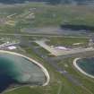
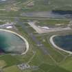
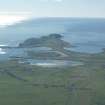
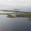
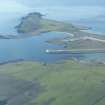
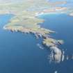
Sumburgh Airport


Airfield (20th Century), Airport (20th Century)
Site Name Sumburgh Airport
Classification Airfield (20th Century), Airport (20th Century)
Alternative Name(s) Sumburgh Airfield
Canmore ID 93088
Site Number HU31SE 34
NGR HU 3952 1060
NGR Description Centred HU 3952 1060
Datum OSGB36 - NGR
Permalink http://canmore.org.uk/site/93088


- Council Shetland Islands
- Parish Dunrossness
- Former Region Shetland Islands Area
- Former District Shetland
- Former County Shetland
HU31SE 34.00 centred 3952 1060
HU31SE 34.01 HU 3912 1106 Pillboxes
HU31SE 34.02 centred HU 3919 1039 Military Camp; Air-raid shelters
HU31SE 34.03 centred HU 3910 1060 Military Camp
HU31SE 34.04 centred HU 3895 1113 Military Camp
HU31SE 34.05 centred HU 3875 1125 Military Camp
HU31SE 34.06 HU 3920 1038 Operations Block
HU31SE 34.07 HU 39285 10605 Control Tower
HU31SE 34.08 centred HU 3908 1113 Military Camp
HU31SE 34.09 HU c. 38837 10810 and HU c. 40265 10992 Underwater survey area (Proposed runway extensions, 2005).
Extends onto map sheets HU30NE, and HU41SW.
For Bomb Store see HU41SW 30.
For aviation fuel tanks see HU40NW 6
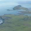
For discoveries of settlement, Viking grave, Viking brooch, broch and ard point within and around the area of the airfield, see HU31SE 1, HU31SE 18, HU31SE 20, HU31SE 21, HU31SE 24 respectively.
For associated radar station (HU 3887 1180), see HU31SE 42.
For military camp (centred HU 3910 1021), see HU31SE 98.
For (military) oil storage tanks centred around HU 4077 0935, see HU40NW 6.
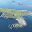
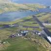
Established in 1933, the RAF took over in 1939 to use it as a fighter station. Not until 1941 were three runways available. At the end of the war it proved a good airfield for post-war Shetland.
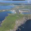
With the oil boom a large capital expenditure programme resulted and the wartime control tower is still in use, albeit modernised. The decontamination centre and squash court still survive.
D J Smith 1983; B Quarrie (ed) 1987.
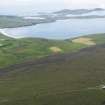
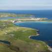
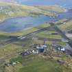
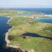
Many brick, concrete and wood World War Two buildings are extant around the airport.
J Guy 1995; NMRS MS 810/4, 72-6
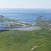
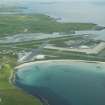
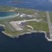
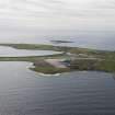
Sumburgh Airfield is visible on RAF WW II vertical air photographs (WL 10, 1.130-1.134 and 2.118-2.121, flown 4 July 1942), which clearly show the mid-wartime layout of the airbase.
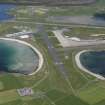
Visible are the three runways, two of which have been partially camouflaged and three aircraft hangars, possibly of the Bellman type. The control tower (HU31SE 34.06) is situated in the NW quadrant behind two of the aircraft hangars.
The bomb store, also visible on this series of air photographs (centred HU 4022 1054), was completely removed during the upgrading to airport during 1975.
The airfield is notable for the related large accommodation camps situated in the surrounding area. Almost all the camps are visible on the wartime photographs and complete coverage of the area is seen on a postwar series of vertical air photographs (106G/UK 97, 3025-3029 and 4027-4033, flown 18 May 1946), all of which clearly show their extent. The location of many of the camps can still be found by the concrete hut bases.
All the aircraft hangars seen on the wartime and postwar photographs have been removed, one may now be situated at HU 39460 10376, and this is visible on air photogrpahs taken in 1989 (All Scotland Survey [Jasair], 27 89 004-005, flown 4-6 July 1989).
The airfield has been extensively modernised with a new terminal building and the one runway being extended to accommodate modern aircraft. The control tower has also been heavily modernised.
Information from RCAHMS (DE), December 2005

