
Rushy Geo


Standing Stone(S) (Prehistoric)
Site Name Rushy Geo
Classification Standing Stone(S) (Prehistoric)
Alternative Name(s) Can 051
Canmore ID 9269
Site Number ND36NE 18
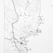
NGR ND 3939 6842
Datum OSGB36 - NGR
Permalink http://canmore.org.uk/site/9269


- Council Highland
- Parish Canisbay
- Former Region Highland
- Former District Caithness
- Former County Caithness
ND36NE 18 3939 6842
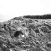
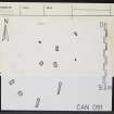
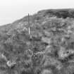
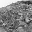
(Area ND 394 684) 'Above the cliffs on the south side of the geo which flanks the promontory on which the broch (ND36NE 2) stands, and at the landward end, is a group of stones - some square in section, some oblong - extending over an area of about 25ft by 16ft. These appear to be the remains of four rows roughly set in alignment some 3ft to 4ft apart. The stones vary in breadth from 1ft to 2ft, projecting about the same extent above ground, and are from 2ft 5ins to 4ft apart. Their object is not apparent.'
RCAHMS 1911, visited 1910.
At ND 3939 6842 are nine stones as described.
Visited by OS (R D) 9 September 1965.
'Landward of the defences there is a curious group of upstanding stones apparently forming 4 rows; object not apparent; very dubiosly may be an example of chevaux-de-frise'
Information from R G Lamb, 1980
Standing stones. Extending over an area of 6 x 5.50m, eight small standing stones of average height 0.30m. No obvious pattern. On the S side of the geo adjacent to Skirza broch. Elevation c.33m. ND 3943 6840.
Dr C E Batey, Caithness Coastal Survey 1980
(ND 3939 6841) Stones (NAT)
OS 25" map, (1969)
The nine upright stones are as described above. The elderly resident of the adjacent farm related local tradition that the stones mark the graves of shipwrecked mariners who were murdered by an old lady when they reached the cliff top. All were killed except the cabin boy who was spared. They may mark the graves of ship-wrecked sailors; they are not the remains of stone rows.
Revised at 1:2500.
Visited by OS (J B) 10 May 1982.
Project (1980 - 1982)
Field Visit (1980)
Standing stones. Extending over an area of 6 x 5.50m, eight small standing stones of average height 0.30m. No obvious pattern. On the S side of the geo adjacent to Skirza broch. Elevation c.33m. ND 3943 6840.
Dr C E Batey, Caithness Coastal Survey 1980

