|
Prints and Drawings |
DC 32185 |
Records of the Royal Commission on the Ancient and Historical Monuments of Scotland (RCAHMS), Edinbu |
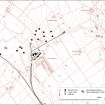
Map showing the mineheads of the Canonbie and Blinkbonny collieries at Rowanburn, together with the evidence of earlier mines identified by fieldwork. Published in Eastern Dumfriesshire: an archaeological landscape. |
1996 |
Item Level |
|
|
Photographs and Off-line Digital Images |
D 88446 CS |
|
Geological sections of Archerbeck coal seams. |
|
Item Level |
|
|
Photographs and Off-line Digital Images |
D 88445 CS |
|
Geological section through the Canonbie coalfield from Rowanburn to Archerbeck. |
|
Item Level |
|
|
Photographs and Off-line Digital Images |
D 88449 CS |
|
Geological section through Canonbie coalfield. |
|
Item Level |
|
|
Photographs and Off-line Digital Images |
D 88450 CS |
|
Geological map of Canonbie coalfield. |
|
Item Level |
|
 |
On-line Digital Images |
SC 1917803 |
Records of the Royal Commission on the Ancient and Historical Monuments of Scotland (RCAHMS), Edinbu |
Map showing the mineheads of the Canonbie and Blinkbonny collieries at Rowanburn, together with the evidence of earlier mines identified by fieldwork. Published in Eastern Dumfriesshire: an archaeological landscape. |
1996 |
Item Level |
|


