
Bentpath, Esk Bridge


Road Bridge (Period Unassigned)
Site Name Bentpath, Esk Bridge
Classification Road Bridge (Period Unassigned)
Alternative Name(s) River Esk; Bentpath Village, Esk Bridge; Bentpath Bridge
Canmore ID 92168
Site Number NY39SW 22
NGR NY 31160 90248
Datum OSGB36 - NGR
Permalink http://canmore.org.uk/site/92168


- Council Dumfries And Galloway
- Parish Westerkirk
- Former Region Dumfries And Galloway
- Former District Annandale And Eskdale
- Former County Dumfries-shire
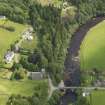
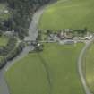
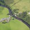
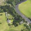
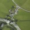
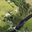
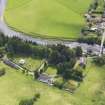
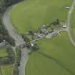
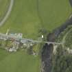
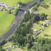
Early 18th century bridge over River Esk, still in use as road bridge, located in historic Bentpath village within wider improved rural landscape of Esk valley.
information from Héléna Gray, (CFA Archaeology Ltd), August 2015
OASIS ID: cfaarcha1-278420
NY39SW 22 31160 90248
Humpbacked two-span bridge built by Andrew Coats and Robert Paisley in 1734-7.
J Gifford 1996.
This bridge carries an unclassified public road over the River Esk in the centre of Bentpath village.
Information from RCAHMS (RJCM), 1 December 1997.
Project (29 May 2014)
An archaeological evaluation was undertaken by CFA Archaeology Ltd, a desk based assessment and walk over survey (May 29th 2014) was conducted
The historic environment record within the Site Boundary is relatively limited, although there is some potential for the proposed development site to contain previously unknown heritage assets from at least the later prehistoric period onwards, given the historic landscape character of the wider area. Taking this into account, the archaeological potential of the proposed development site is considered to be low.
A summary assessment, on a site by site basis, of the predicted effects on the settings of assets within a 10km radius where the blade tip ZTV indicates that there would be theoretical views of one or more turbines
information from Héléna Gray, (CFA Archaeology Ltd), August 2015
OASIS ID: cfaarcha1-278420

