
Dundonald Airfield


Airfield (20th Century)
Site Name Dundonald Airfield
Classification Airfield (20th Century)
Alternative Name(s) Hms Dundonald Ii
Canmore ID 91849
Site Number NS33NE 41
NGR NS 355 352
NGR Description Centred NS 355 352
Datum OSGB36 - NGR
Permalink http://canmore.org.uk/site/91849


- Council South Ayrshire
- Parish Dundonald (Kyle And Carrick)
- Former Region Strathclyde
- Former District Kyle And Carrick
- Former County Ayrshire
NS33NE 41 centred 355 352
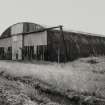
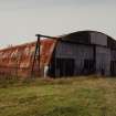
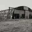
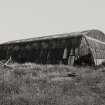
A small grass airfield used for advance training for the Normandy Landings. The autumn of 1943 saw the reconstruction of the main runway at Dundonald. On September 2 1944 the station was placed on a care and maintainance basis. On 1 August 1945 the airfield officially closed although the site was retained by the Army. It is now farmland, though the runways can still be traced in the fields.
D J Smith 1983; B Quarrie 1987
The airfield is visible on vertical air photograph, (OS 78/109/001, flown 1978).
Information from RCAHMS (DE) August 1996.

