|
Manuscripts |
MS 1000/7 |
Records of the German Air Force (Luftwaffe), Second World War Aerial Reconnaissance |
Photocopy of Luftwaffe aerial photograph. |
9/1/1941 |
Item Level |
|
|
Photographs and Off-line Digital Images |
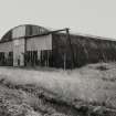
B 56322 |
|
View from NE. |
7/8/1991 |
Item Level |
|
|
Photographs and Off-line Digital Images |
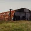
B 56323 |
|
View from SE. |
7/8/1991 |
Item Level |
|
|
Photographs and Off-line Digital Images |
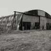
B 56323 CN |
|
View from SE. |
7/8/1991 |
Item Level |
|
|
Photographs and Off-line Digital Images |
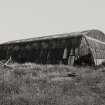
B 56324 |
|
View from NW. |
7/8/1991 |
Item Level |
|
|
Manuscripts |
MS 2043/539 |
Records of the Council for British Archaeology, York, England |
Defence of Britain Project. Council of British Archaeology.
North Ayrshire Region
Details of several sites located in North Ayrshire associated with various Defence activities. |
5/11/97 |
Item Level |
|
|
Manuscripts |
MS 2043/695 |
Records of the Council for British Archaeology, York, England |
Defence of Britain Project. Council of British Archaeology.
South Ayrshire
Detail of disused Airfield located near Dundonald, Ayrshire. |
|
Item Level |
|
|
Manuscripts |
MS 879/102 |
|
British Airfields, past and present. Map showing all British airfields to compliment the Merseyside Avaiation Society publication 'British Isles Airfield Guide'. |
1976 |
Item Level |
|
 |
On-line Digital Images |
SC 2615856 |
|
View from NE. |
7/8/1991 |
Item Level |
|
 |
On-line Digital Images |
SC 2615857 |
|
View from SE. |
7/8/1991 |
Item Level |
|
 |
On-line Digital Images |
SC 2615858 |
|
View from SE. |
7/8/1991 |
Item Level |
|
 |
On-line Digital Images |
SC 2615859 |
|
View from NW. |
7/8/1991 |
Item Level |
|


