
Brough Head


Broch (Iron Age), Settlement(S) (Prehistoric), Wheelhouse (Iron Age), Ard (Period Unassigned), Hammerstone (Period Unassigned), Rotary Quern (Period Unassigned), Unidentified Pottery(S) (Period Unassigned)
Site Name Brough Head
Classification Broch (Iron Age), Settlement(S) (Prehistoric), Wheelhouse (Iron Age), Ard (Period Unassigned), Hammerstone (Period Unassigned), Rotary Quern (Period Unassigned), Unidentified Pottery(S) (Period Unassigned)
Alternative Name(s) Pool Of Virkie; Eastshore
Canmore ID 918
Site Number HU41SW 4
NGR HU 40233 11254
Datum OSGB36 - NGR
Permalink http://canmore.org.uk/site/918


First 100 images shown. See the Collections panel (below) for a link to all digital images.
- Council Shetland Islands
- Parish Dunrossness
- Former Region Shetland Islands Area
- Former District Shetland
- Former County Shetland
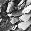
Brough Head, Eastshore, Dunrossness, portable carved stone disc
Measurements: Diam 55mm, D 10mm
Stone type: fine-grained sandstone
Place of discovery: HU 40231125
Present location: Shetland Museum, Lerwick (SM 2010)
Evidence for discovery: stray find from the beach in the central area of the eroding broch.
Present condition: some edge damage.
Description:
One broad face of this disc is carved with a sunken pit, off-centre, and a grid of incised lines forming regular cells. It could be a re-used fragment of gaming board. On the other side are irregular incised lines.
Date: late iron age/early medieval.
References: DES 12 (2011), 172.
Compiled by A Ritchie 2016
HU41SW 4 4023 1125.
(HU 4022 1126) Brough (OE) (Site of)
OS 6" map, Shetland, 2nd ed., (1903).
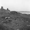
A broch, damaged by the sea and by comparatively modern but disused dwellings. It has an unusually large cluster of outbuildings, the whole complex probably covering about an acre. It has yielded numerous fragments of broch pottery.
RCAHMS 1946, visited 1930.
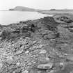
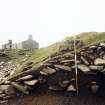
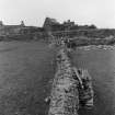
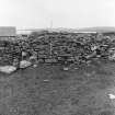
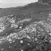
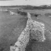
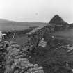
The broch wall has probably been about 15' thick with an internal diameter of about 35', excluding a 5' thick secondary facing. About 20' of inner wall with scarcement shows on the SW quadrant and about 15' of gallery wall on the north side. A great outer wall 30' from the broch still stands to a maximum height of 8'. A kitchen-midden in the shore edge contains animal, bird and fish bones, and shell-fish.
J Stewart 1956.
The remains of a broch generally as described, now mostly destroyed by erosion. The walling is 3.8m thick; the overall diameter can no longer be ascertained. Within the broch on the W side are two radial piers of a wheelhouse, widening from the base, the roof having been supported by the broch scarcement. The outer rampart is as described; the numerous outbuildings are obscured by later buildings.
Re-surveyed at 1/2500.
Visited by OS (NKB) 23rd May 1968.
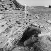
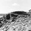
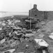
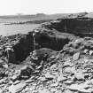
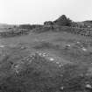
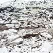
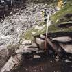
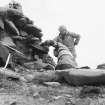
A plane table survey at scale 1:250 was produced of features both ancient and modern present on the Brough Head site. All features were numbered and described in detail, giving where possible the stratigraphical relationships. The south and east sides of the site have been badly affected by coastal erosion with less than half of the broch remaining. A section was drawn across the broch wall where the outer and inner faces survived. A large weathering midden deposit adjacent to the broch was cleaned and drawn. It produced many finds, especially pottery. Finds of pottery were also made in other parts of the site from areas of rabbit and sheep disturbance.
P Strong and A Haggarty 1983
A re-examination of midden and internal broch deposits was undertaken to provide samples for radiocarbon dates and micro-faunal analysis. In the course of this work new evidence for the broch structure was revealed. The excavation also produced a small assemblage of finds including pottery, worked stone, steatite and a fragment of cloth.
R McCullagh 1989b.
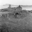
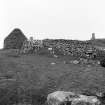
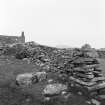
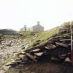
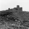
Field Visit (17 July 1930)
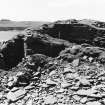
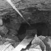
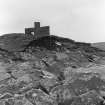
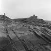
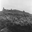
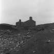
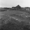
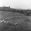
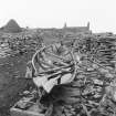
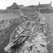
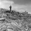
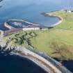
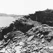
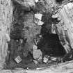
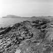
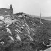
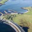
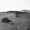
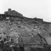
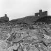
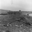
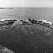
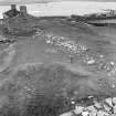
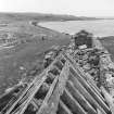
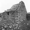
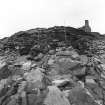
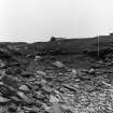
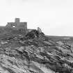
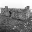
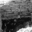
Broch, Brough Head, Eastshore. On a small headland jutting out into the sea a little S.E. of the scattered township of Eastshore, and not far from the entrance to the Pool of Virkie, there are clear traces of a broch, round which there has been an unusually large cluster of ‘out-buildings’. The site is exposed to the full force of the tides, and much damage has been done by the sea eating into the bank. Moreover, not a little confusion has been introduced by the comparatively modern, though now disused, dwellings that have been erected on the site. As a result, what is left, even of the main structure, is in such a ruinous condition that no definite measurements or details can be given. At one place, however, close to the beach, a chamber or gallery is discernible within the thickness of the wall, but owing to dilapidation no entrance to it can be obtained. The area covered by the broch and its ‘outbuildings’ must have been at least an acre in extent. It has yielded numerous fragments of typical broch-pottery. Among the rocks in front are two small creeks, convenient for embarking in or landing from boats, which, when not in use, could have been drawn up on the shore hard by. The broch may have given a name to the Pool, for ‘Virkie’ is derived from a Scandinavian word for a fort.
RCAHMS 1946, visited 17 July 1930 .
OS 6" map, Shetland, 2nd ed., (1903).
Field Visit (23 May 1968)
The remains of a broch generally as described, now mostly destroyed by erosion. The walling is 3.8m thick; the overall diameter can no longer be ascertained. Within the broch on the W side are two radial piers of a wheelhouse, widening from the base, the roof having been supported by the broch scarcement. The outer rampart is as described; the numerous outbuildings are obscured by later buildings.
Re-surveyed at 1/2500.
Visited by OS (NKB) 23rd May 1968.
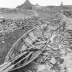
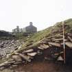
Excavation (1983)
A plane table survey at scale 1:250 was produced of features both ancient and modern present on the Brough Head site. All features were numbered and described in detail, giving where possible the stratigraphical relationships. The south and east sides of the site have been badly affected by coastal erosion with less than half of the broch remaining. A section was drawn across the broch wall where the outer and inner faces survived. A large weathering midden deposit adjacent to the broch was cleaned and drawn. It produced many finds, especially pottery. Finds of pottery were also made in other parts of the site from areas of rabbit and sheep disturbance.
P Strong and A Haggarty 1983
Excavation (1989)
A re-examination of midden and internal broch deposits was undertaken to provide samples for radiocarbon dates and micro-faunal analysis. In the course of this work new evidence for the broch structure was revealed. The excavation also produced a small assemblage of finds including pottery, worked stone, steatite and a fragment of cloth.
R McCullagh 1989b.
Publication Account (2002)
HU41 4 EASTSHORE ('Brough Head')
HU/402113
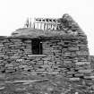
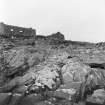
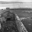
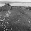
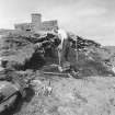
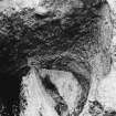
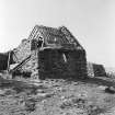
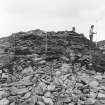
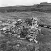
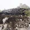
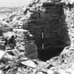
Broch, probably solid-based, in Dunrossness, standing on the edge of a cliff on a small headland and partly destroyed by the sea and surrounded by modern, disused buildings [1, 2] (Ill. 4.59). It was partially excavated in 1989 by digging two trenches across the mound [3] (Ill. 4.53).
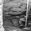
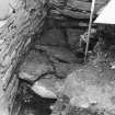
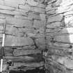
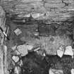
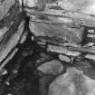
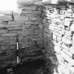
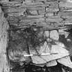
Before this a secondary wall about 5 ft. thick could be seen inside the broch as well as traces of two radial piers on the west side [3]. About 20 ft. of inner wall face, with a scarcement was exposed on the SW side (Ill. 4.59) and traces of about 20 ft. of an intra-mural gallery were observed on the north side close to the beach [1, 2]. The broch could be seen to contain a wheel-house. There is a large cluster of outbuildings and an outer rampart was referred to but not described [1].
A plane table survey of the site was made in 1983 and suggested that a considerable prehistoric settlement lay around the broch, not much smaller than that existing at Jarlshof [5, 449-50 and Ill. 12].
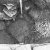
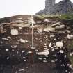
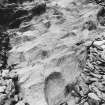
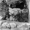
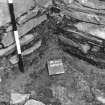
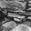
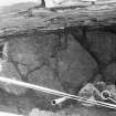
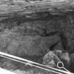
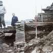
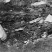
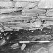
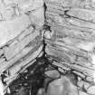
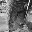
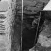
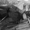
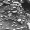
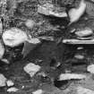
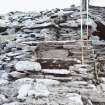
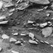
The two 1989 trenches revealed midden deposits of pre-broch date; the broch wall was founded directly on them. This wall had a massive foundation course, or plinth, projecting 55 cm in front of the battered wall face above, and the latter rose to a maximum height of 2.7 m. The lintelled entrance to a probable intra-mural cell was found on the inner wall face on the west side, 95 cm below a massive scarcement of the ledge type which was 1.7m above the foundation level. Traces of curved wall faces were found on the untrenched wallhead which seem likely to belong to a Level II (first storey) intra-mural gallery, confirming the diagnosis of the building as a hollow-walled broch.
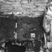
Two radial piers were found to have been added to the inner wall face on the south side; they evidently also rested on the pre-broch midden deposits, with their foundation courses a little below that of the adjacent broch wall. The inner face of each pier had been faced with a stone slab and the inner edge of the bay so defined was edged with a sill formed of stone slabs on edge. The floor of the bay had been lined with a thick layer of yellow clay (which covered the bottom courses of both piers and broch wall) with a paving of small slabs on top of this. Three superimposed occupation deposits, each covered with paving, were found on top of this and most of the Iron Age pottery and finds recovered came from these. Rubble from the dilapidation of the broch was on top of these.
An extensive external midden was found in the second trench, resting on the underlying till. A series of C-14 dates suggested that this began to accumulate early in the 1st millennium AD and continued until the middle or late part of it. The whole range of C-14 dates obtained suggests that the settlement may go back well into the 1st millennium B.C. [5, Table 4 in microfiche].
Finds: the pottery found has been illustrated [5, fig. 00]. Most of the rim sherds indicate simple, plain barrel-shaped vessels, and one small pot has an everted rim. One decorated vessel was found (V6) -- an everted rim jar with a highly polished (presumably black) outer surface, fluting along the inside face of the rim, oblique incised lines on the exterior immediately below the rim, with another row of incised marks just above the base. The black burnishing, the everted rim and the fluting can also be seen on the large sherd from Mousa (Ill. 4.58).
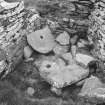
Stone implements include pounders, half of the upper stone of a rotary quern (in the upper levels of the midden) and some sub-rectangular stone plaques.
Cloth: traces of woollen fabric were found in one of the occupation layers inside the broch.
Discussion: the excavators were unable to decide whether the radial piers inside the broch were built upon the top of a pre broch midden which had been eroded down below the foundations of the adjacent main wall, or whether the surface had been deliberately cut down to accommodate the piers. The former would imply a long period of abandonment (but would not explain how 'erosion' could occur inside even the stump of a massive stone tower) whereas the latter would suggest that the secondary occupants had cleared away the debris of the primary broch occupation for their new structure, presumably a wheelhouse. The second view seems much more plausible.
The time of the construction of the broch could not be pinned down closer than about the first centuries BC or AD with the C-14 dates obtained. These do suggest that the broch may have continued in occupation (though doubtless reduced in height) until the middle of the 1st millennium AD.
Dimensions: estimated overall diameter after excavations, 19.4m; wall thickness c. 4.4 m; the wall proportion would thus be about just over 45% (though the exposed segment of outer face is not circumferential to the inner [5, illus. 14]).
Sources: 1. OS card HU 41 SW 4: 2. RCAHMS 1946, vol. 3, no. 1148: 3. Discovery and Excavation, Scotland, 1956, 27-8. 4. Ibid, 1989, 68: 5. Carter, McCullagh and MacSween 1996, 447-64 and microfiche.
E W MacKie 2002
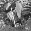
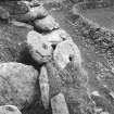
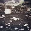
Artefact Recovery (2017)
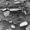
HU 4015 1125 The items listed below were found eroding from the internal area of the broch, which is itself falling into the sea, during a visit in 2017. A complete ard, a double ended hammerstone, and six pottery sherds including two rim sherds were recovered and handed in to Lerwick Museum. Also lying in situ was a complete upper stone of a rotary quern, this was left on site but the museum was notified of its imminent danger of falling into the sea.
Sandra Kelly - North Clyde Archaeological Society
(Source: DES, Volume 18)

