
Machrihanish Airfield


Airfield (20th Century)
Site Name Machrihanish Airfield
Classification Airfield (20th Century)
Alternative Name(s) Rnas Strabane; Rnas Machrihanish; Hms Landrail; Raf Machrihanish; Campbeltown Airport
Canmore ID 91750
Site Number NR62SE 28
NGR NR 66231 22306
NGR Description Centred NR 66231 22306
Datum OSGB36 - NGR
Permalink http://canmore.org.uk/site/91750


- Council Argyll And Bute
- Parish Campbeltown
- Former Region Strathclyde
- Former District Argyll And Bute
- Former County Argyll
NR62SE 28.00 centred 66231 22306
NR62SE 28.01 NR 66208 22647 Control Tower (New)
NR62SE 28.02 NR 66365 22856 Control Tower (Old)
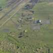
NR62SE 28.03 Centred NR 66373 22778 Buildings; Aircraft Hangar; Huts
NR62SE 28.04 Centred NR 66462 23343 Buildings; Office; Gymnasium; Huts; Houses
NR62SE 28.05 Centred NR 66384 23601 Buildings; Houses; Huts; Squash Court; Hospital
NR62SE 28.06 Centred NR 66499 23720 Houses
NR62SE 28.07 Centred NR 66579 23438 Houses
NR62SE 28.08 Centred NR 65576 23313 Bomb Store (Conventional)
NR62SE 28.09 Centred NR 65742 23536 Bomb Store (Nuclear)
NR62SE 28.10 NR 66563 22592 Firing Range
NR62SE 28.11 NR 68363 23344 and NR 68406 23346 Garage (MT sheds)
NR62SE 28.12 Centred NR 65922 21634 Aircraft Hangar; Buildings
For (Parkfergus) logboat found on the S side of the airfield, see NR62SE 3.
For wind farm construction yard (centred NR 66232 23016) within the area of the airfield, see NR62SE 35.
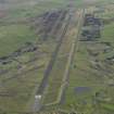
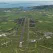
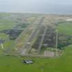
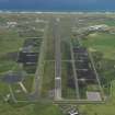
Unusual in that it had three separate periods of existence, it began life in August 1918 as a sub-station of the airship base at Luce Bay. Closing in late 1918, it was rebuilt at the beginning of the WWII, becoming HMS Landrail during 1941. Early in 1945, it became disused but was maintained until December 1951 when it recommissioned for training. Abandoned a second time in 1953, the airfield underwent major reconstruction for NATO in 1960/62, also becoming a US Navy weapons facility and Master Diversion Airfield. The four runways were replaced by a 10,000ft strip. BEA/BA services were flown to Islay and Glasgow until taken over by Loganair in 1977.
D J Smith 1983
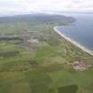
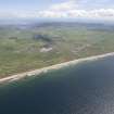
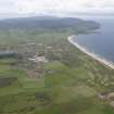
This World War II airfield is situated to the N of the Macrihanish water and W of Aros Moss. At the time of visit the airfield was still is use by the military. Wartime structures are extant around the airfield with many in use as farm buildings and transport depots. (The airfield has since been closed by the Ministry of Defence and now lies unused)
J Guy 2001; NMRS 810/11, Part 1, 38-41
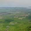
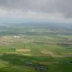
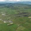
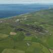
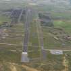
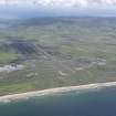
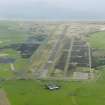
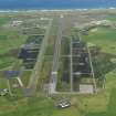
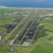
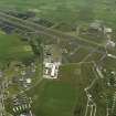
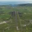
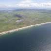
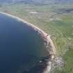
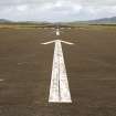
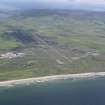
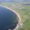
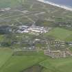
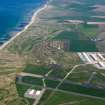
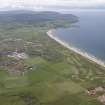
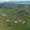
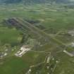
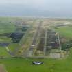
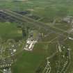
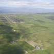
RAF Machrihanish airfield, now Campeltown Airfield is situated immediately E of the Links of Machrihanish and W of the main A 83 road from Campbeltown to Tarbert. The site occupies an area of about 410.8 hectares with a main runway of about 3,079m. The military base is situated on the N side with the more recent civilian airport at the E end of the main runway.
The airfield is now up for sale following the handing back to the Ministry of Defence (MoD) in 1995 by the United States Navy who had used the base as part of the NATO committment.
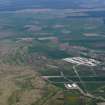
Most of buildings within the former base date from the post war period, most notably the decade following the major reconstruction and development between 1960-1970 to allow Vulcan bombers and other large aircraft to use the facilities. The US Navy established a weapons facility on the site, particularly for nuclear mines. Accommodation and training facitlities were added, the resultant completed buildings being found at the SW and N ends of the airfield. Several US special units were based at the site. A Gaydon aircraft hangar and parachute drying tower with operations building were added to the SW area.
Following the handing back to the MoD the base was redesignated as MoD Machrihanish and was used by the Britiah Army for training purposes.
Little survives of the World War Two period, only one or two buildings were noted along with part of the old bomb store and information passed to RCAHMS by Defence Estates would suggest that many of the existing older structures date to the late 1940's and early 1950's rather than 1939-45 period, despite being of WW II design types. The gymnasium , squash court and several of the huts would fall into this category. No wartime aircraft hangars survive on the site.
Entry to the former military area is still restricted.
Visited by RCAHMS (DE, JM), 22-24th September 2009

